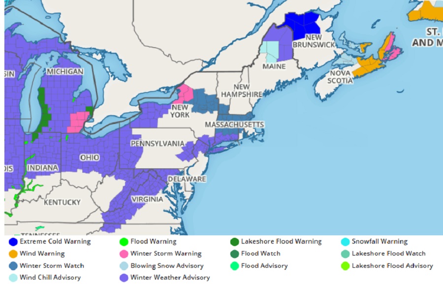
The National Weather Service has started issuing advisories in the northeast ahead of a wintry weather event that’ll bring a mixed bag of precipitation to the northeast. Winter Weather Advisories are now up for portions of Virginia, Maryland, Pennsylvania, New Jersey, Connecticut, and New York. With heavier amounts of snow expected, Winter Storm Warnings have been issued for portions of Michigan and New York.
Breezy northwest winds earlier today set the stage for a winter storm, providing cold air to start the storm. With the cold air in place, temperatures are forecast to be below normal for the first time in over a week for much of the Mid Atlantic and Northeast. The center of the area of high pressure responsible for today’s fair conditions is expected to pass across southern Quebec tonight. As the high moves out, there will be an increase in high clouds from the west tonight, out ahead of the next weather system.
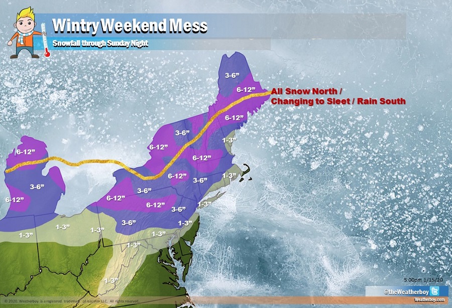
Most wintry precipitation will arrive in the northeast on Saturday. A surface ridge will be straddling the east coast Saturday morning as a progressive mid-level ridge moves through the northeast. Upstream, a fairly potent trough will be migrating through the central U.S., as a related surface low begins to lift into the Midwest. Warm advection will begin in earnest Saturday morning in advance of the trough, with clouds quickly thickening and lowering. However, residual dry air will exist in the low levels of the atmosphere. As moisture hits this dry air, temperatures will cool and the air will dry somewhat; however, once it becomes saturated, snow will eventually fall. However, warm advection will be significant as this weather system moves through, which will transition snow to rain from south to north. Before snow completely changes to rain, there could also be a prolonged period of sleet, especially in eastern Pennsylvania and central New Jersey. While some light snow is expected around the I-95 corridor from New York south towards Washington, DC, it should eventually change to rain, washing away any evidence of the earlier snowfall. Further to the north and west, the change-over will occur later, allowing for more snow to fall. And across northern interior New England, the precipitation should remain as all snow with milder air from the south unable to penetrate the cold air there.
After this winter storm exits, a strong, broad, and cold surface high pressure system will become established in the eastern half of the U.S. It is likely that this high will be strong enough to keep it cold and dry for the northeast for most of the week, excluding some lake effect snows that could fall. Another weather system will approach towards the end of the week, but it will also arrive with milder air, killing odds of a significant I-95 winter storm any time soon.
