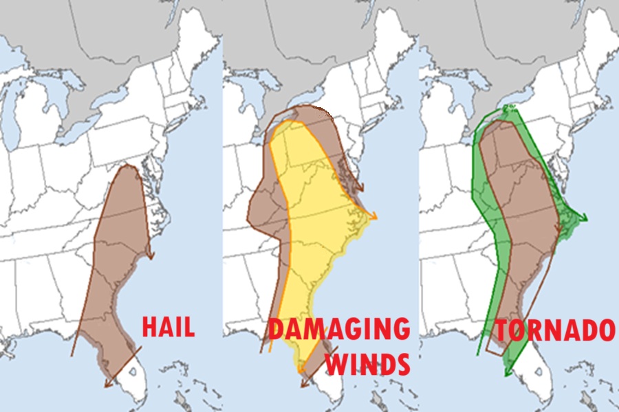
After a deadly night of tornadoes that killed at least 34 people across the United States, tornadic storms will head east to the East Coast and forecasters are warning of one more day of violent weather today. The National Weather Service’s Storm Prediction Center (SPC) warns that sporadic damaging wind swaths and a few tornadoes will be the primary threats this morning through dusk across a broad portion of the East, with severe weather wrapping up later today …but not before a large area is exposed to a variety of weather hazards.
The SPC says there are risks of destructive wind gusts, large, damaging hail, and potentially lethal tornadoes across a significant part of the U.S. East. According to the SPC, there are more than 316,000 square miles at risk from dangerous severe thunderstorms today, impacting populated areas containing upwards of 58.6 million people.
Our hearts go out to all of those impacted by this week’s severe weather event. 💔 https://t.co/gc7rJHKEhh
— the Weatherboy (@theWeatherboy) March 16, 2025
The National Weather Service says that a seasonally strong upper trough, though bimodal in nature, will shift into the Ohio Valley and Southeast by the end of the day. Ahead of the main trough, a lead mid-level speed max will evolve across eastern Ohio and western Pennsylvania; this meteorological feature will be partly responsible for sustaining a surface low that should track from southeast lower Michigan into Ontario, Canada by early afternoon. Additionally, a low-level jet is forecast to increase markedly across western Pennsylvania early today which will aid moistening the atmosphere ahead of the short wave.
Early today, an elongated corridor of convection and precipitation will extend from the Florida Panhandle northeast into Ohio. Warm advection will likely maintain this activity which will be ongoing this morning. The latest computer forecast model guidance suggests a secondary band of convection will develop along and ahead of the front by mid-late morning, and an upward evolving, strongly forced line of storms, and a few embedded supercells, will surge east into western Pennsylvania.
According to the SPC, damaging winds seem plausible with this convection, and profiles also favor some risk for a few brief tornadoes.
Meanwhile, mid-level heights will fall across the southeastern U.S. early today as low-latitude jet core shifts east along the Gulf Coast into Georgia. This will ensure the primary synoptic front progresses steadily east through the period. By this afternoon, the wind shift should extend from the southern Appalachians into the eastern Florida Panhandle. Scattered strong to severe convection, with some risk for supercells, will be possible ahead of the surging boundary area. Forecast soundings exhibit conditions that support the risk of a few tornadoes. Steep mid-level lapse rates also suggest that the more robust updrafts should generate hail.
Overall, severe threat will shift east/southeast through the period before drawing to a close tonight at the coast.
While severe weather will be likely across a broad area, one area now believed to escape the worst of the weather will be Delaware, New Jersey, and points north and east. There, stable air has entered the region, creating a situation that is creating more fog than severe storms. In fact, Dense Fog Advisories are up for portions of northeastern Pennsylvania, the Jersey coast, and the Long Island sound, with words of caution being shared with adjacent areas over land by the National Weather Service. With this stable air mass here, severe weather is less likely to enter this part of the eastern U.S..
