At the 2022 National Tropical Weather Conference in South Padre Island, Texas today, the nation’s leading hurricane forecasters shared their seasonal outlook for the upcoming Atlantic Hurricane Season and the forecast doesn’t look good: the season is forecast to feature an above number of tropical storms and hurricanes, above normal major hurricanes, above normal days with a tropical storm or hurricane, and above normal accumulated cyclone energy. In addition to those statistics, experts say there’s higher than normal chances that a storm will landfall along the U.S. East Coast, the Gulf Coast, and across the Florida Peninsula.
“So far, the 2022 hurricane season is exhibiting characteristics similar to 1996, 2000, 2001, 2008, 2012 and 2021. “Our analog seasons generally exhibited near- to somewhat above-normal Atlantic hurricane activity,” said Phil Klotzbach, research scientist in the Department of Atmospheric Science at Colorado State University (CSU) and lead author of the report.
This is the 39th year that the CSU hurricane research team has issued an Atlantic basin seasonal hurricane forecast. The Tropical Meteorology Project team also includes Michael Bell, professor in the CSU Department of Atmospheric Science. Bill Gray, who originated the seasonal forecasts, launched the report in 1984 and continued to author them until his death in 2016.
The seasonal outlook was unveiled at the National Tropical Weather Conference in Texas where the nation’s leading tropical meteorology experts, broadcast meteorologists, and disaster preparedness officials and experts gather ahead of the Atlantic Hurricane Season which runs from June through November. Weatherboy is an official sponsor of both the National Tropical Weather Conference and the CSU Tropical Weather Project report. Weatherboy joins EVEX, the Insurance Information Institute, and Ironshore to support the CSU research.
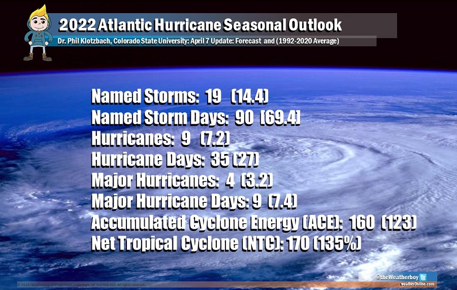
Based on the outlook released today, the 2022 Atlantic Hurricane Season will have activity above the 1991–2020 average. We estimate that 2022 will have 9 hurricanes (average is 7.2), 19 named storms (average is 14.4), 90 named storm days (average is 69.4), 35 hurricane days (average is 27.0), 4 major (Category 3-4-5) hurricanes (average is 3.2) and 9 major hurricane days (average is 7.4). The probability of U.S. major hurricane landfall is estimated to be about 135 percent of the long-period average. The CSU team will re-examine data throughout the year, adjusting forecast numbers on June 2, July 7, and August 7.

The research report, found in its entirety here, also includes landfalling probability metrics by region. According to today’s report, there’s a 71% for the entire U.S. coastline (average for the last century is 52%), 47% for the U.S. East Coast including the Florida peninsula (average for the last century is 31%), 46% for the Gulf Coast from the Florida panhandle westward to Brownsville (average for the last century is 30%), and 60% for the Caribbean (average for the last century is 42%).
Regardless of the outlook, forecasters warn that even just one storm can be dangerous. The CSU forecast team say today’s report is intended to provide a best estimate of activity in the Atlantic during the upcoming season and is not an exact measure. Even so, the researchers caution coastal residents to take proper precautions. “It takes only one storm near you to make this an active season,” Bell said.
