The National Hurricane Center is keeping a close eye on the Atlantic Hurricane Basin where a new system is likely to form; with a east coast hurricane threat possible in about 7-10 days, people should be on alert as the peak of the hurricane season nears.
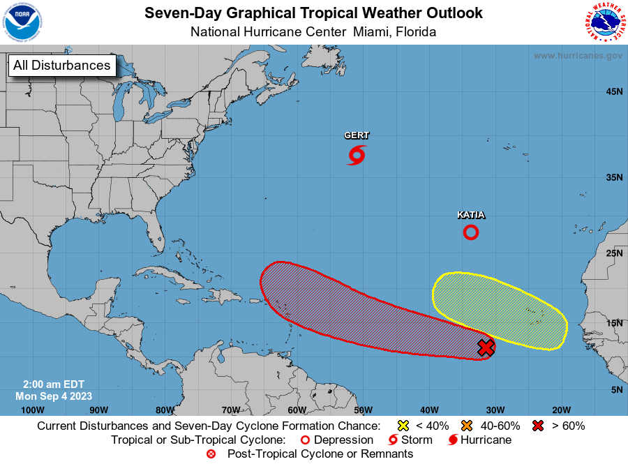
The National Hurricane Center is also issuing advisories on Tropical Storm Gert, located over the central subtropical Atlantic, and on recently downgraded Tropical Depression Katia, located over the eastern subtropical Atlantic. Neither are a threat to any land mass at this time.
However, a system developing in the Atlantic now may not be as benign. Showers and thunderstorms continue to show signs of organization in association with a tropical wave located several hundred miles southwest of the Cabo Verde Islands. According to the National Hurricane Center, environmental conditions are forecast to be conducive for further development, and this system is expected to become a tropical depression in two or three days. Additional strengthening is likely late this week while the system moves westward to west-northwestward at 15 to 20 mph over the central and western portions of the tropical Atlantic. Right now, the National Hurricane Center believes there’s a 60% chance of tropical cyclone formation over the next 48 hours; those odds increase to 90% over the next 7 days.
Computer forecast guidance suggests this system will develop into a robust hurricane over time. Guidance also suggests impacts along the U.S. East Coast possible in about 7-10 days, although it is far too soon to say where, if anywhere, the storm will make landfall. As is the case throughout hurricane season, people living from Florida to Maine are advised by the National Weather Service to make sure they have a Hurricane Action Plan in order.
There is a second system in the far Atlantic that the National Hurricane Center is monitoring too. A tropical wave is forecast to move off the African coast in a couple of days. Environmental conditions could support some slow development starting midweek while the wave moves to the west-northwest at about 15 mph over the far eastern tropical Atlantic. Right now, there’s only a 30% chance that this system will develop into a tropical cyclone over the next 7 days.
