The latest Tropical Outlook from the National Hurricane Center in Miami shows a few areas of concern in the Atlantic, but no immediate threat to the U.S. is expected from tropical cyclones in the coming 5 days. The same is true in Hawaii where the Central Pacific Hurricane Center expects no tropical cyclones over the next 5 days.
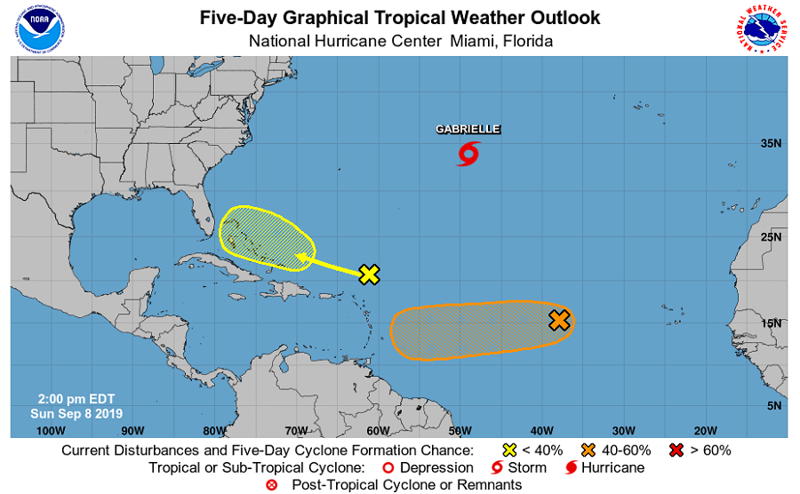
While the Canadian east coast continues to deal with impacts associated with Post Tropical Cyclone Dorian, the rest of the waters around the U.S. coastline are free of tropical cyclones for now. While that should remain the case for the next five days, the National Hurricane Center is tracking Tropical Storm Gabrielle over the central Atlantic Ocean and two other areas that could develop over time.
The first area of concern is in the central Atlantic well south of Gabrielle. A broad area of low pressure and an associated tropical wave are producing showers and thunderstorms several hundred miles west of the Cabo Verde Islands. According to the National Hurricane Center, some slow development of this system is possible during the next several days while the low moves westward across the central tropical Atlantic Ocean. At this time, the National Hurricane Center believes there’s only a 20% chance that a tropical cyclone will form here over the next 2 days; however, those odds increase to 40% over the next 5 days.
The next area of concern is closer to the United States but less likely to develop. A large area of disorganized showers and thunderstorms located a few hundred miles north and northeast of the northern Leeward Islands is associated with a trough of low pressure. According to the National Hurricane Center, strong upper-level winds are expected to prevent the development of this system during the next few days while it moves west-northwestward to the north of the Leeward Islands and Puerto Rico. By mid week, environmental conditions could become more conducive for development when the disturbance reaches the southwestern Atlantic Ocean. At that point, it’ll need to be closely monitored. For now, there’s only a 20% chance that a tropical cyclone will form here over the next 5 days.
The 2019 Hurricane Season for both the Atlantic and Central Pacific run through to the end of November.
