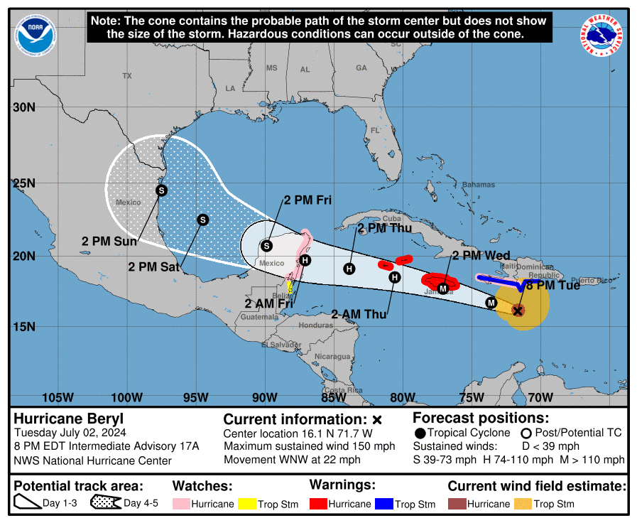
Major Hurricane Beryl, which has featured winds at/around category 5 status on the Saffir-Simpson wind scale over the last 24 hours, is about to punish Jamaica with an epic storm surge, destructive winds, and very heavy rains. Landfall on the island is forecast to occur tomorrow over Jamaica before the powerful storm rakes the Cayman Islands Wednesday night and Thursday.
As of the latest advisory from the National Hurricane Center (NHC), Beryl was located about 360 miles east-southeast of Kingston, Jamaica. Maximum sustained winds are down to 150 mph, making it a powerful high-end category 4 hurricane. The storm is moving west-northwest at 22 mph while the minimum central pressure is at 943 mb or 27.85″.
Numerous watches and warnings are up, with new ones just issued. The government of Mexico has issued a Hurricane Watch for the east coast of the Yucatan Peninsula from Chetumal to Cabo Catoche. The government of Belize has issued a Tropical Storm Watch from south of Chetumal to Belize City.
A Hurricane Warning is in effect for Jamaica, Grand Cayman, Little Cayman, and Cayman Brac. A Hurricane Watch is in effect for the south coast of Haiti from the border with the Dominican Republic to Anse d’Hainault and the east coast of the Yucatan Peninsula from Chetumal to Cabo Catoche. A Tropical Storm Warning is in effect for the south coast of Dominican Republic from Punta Palenque westward to the border with Haiti and the south coast of Haiti from the border with the Dominican Republic to Anse d’Hainault. Lastly, a Tropical Storm Watch is in effect for the coast of Belize from south of Chetumal to Belize City.
A Hurricane Warning means that hurricane conditions are expected somewhere within the warning area. Preparations to protect life and property should be rushed to completion.
A Tropical Storm Warning means that tropical storm conditions are expected somewhere within the warning area within 36 hours.
A Hurricane Watch means that hurricane conditions are possible within the watch area. A watch is typically issued 48 hours before the anticipated first occurrence of tropical-storm-force winds, conditions that make outside preparations difficult or dangerous.
A Tropical Storm Watch means that tropical storm conditions are possible within the watch area, generally within 48 hours.

While Beryl is moving west-northwest now, and this general motion should continue through Wednesday, it should turn more toward the west Wednesday night or Thursday. On the forecast track, the center of Beryl will move rapidly across the central Caribbean Sea tonight and is forecast to pass near or over Jamaica on Wednesday. The center is expected to pass near or over the Cayman Islands Wednesday night or early Thursday and approach the Yucatan Peninsula of Mexico Thursday night.
Maximum sustained winds are near 150 mph with higher gusts. Weakening is forecast during the next day or two. However, Beryl is forecast to be at or near major hurricane
intensity while it passes near Jamaica on Wednesday and the Cayman Islands on Wednesday night. Additional weakening is expected thereafter, though Beryl is forecast to remain a hurricane in the northwestern Caribbean.
The National Hurricane Center has 4 key messages they wish to get out now about this storm:
- Devastating hurricane-force winds, life-threatening storm surge, and damaging waves are expected in portions of Jamaica and the Cayman Islands Wednesday and Wednesday night. Residents in these areas should listen to local government and emergency management officials for preparedness and/or evacuation orders.
- Heavy rainfall and life-threatening flash flooding are likely over much of Jamaica and southern Hispaniola through late Wednesday.
- Beryl is forecast to remain a hurricane when it approaches the Yucatan Peninsula and Belize late Thursday where additional watches will likely be required later today or tonight.
- There remains uncertainty in the track and intensity forecast of Beryl over the western Gulf of Mexico this weekend. Interests in the southwestern and western Gulf of Mexico should monitor the progress of Beryl.