A powerful blizzard continues to blast the northeast with heavy snow, damaging winds, and rising coastal tides leading to flooding at the shore.
The storm has moved further west than originally expected, pushing the snow/sleet/rain line further inland as a result. The storm continues to evolve and wobble; areas that saw snow change to sleet this morning will see a change-over back to snow. Areas that saw plain rain and freezing rain in portions of central and western New Jersey will change back to sleet and perhaps snow. Rain falling over far southern New Jersey, central and southern Delaware, and eastern Maryland will remain as rain with little to no accumulation expected.
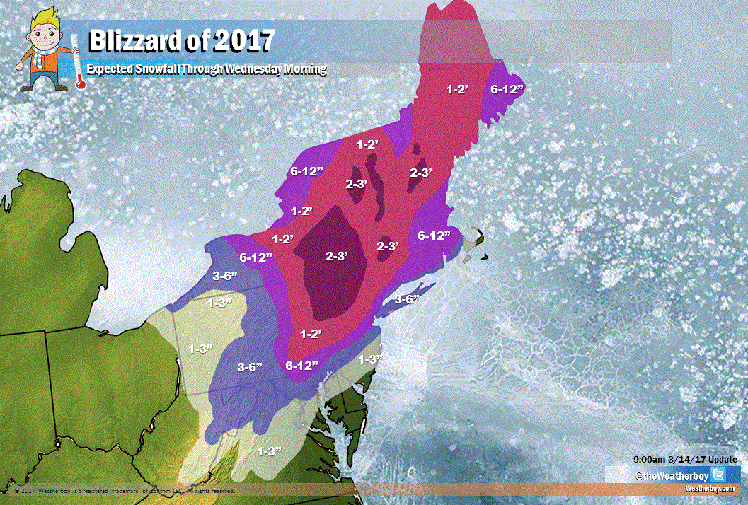
While the snow/sleet/rain line moved inland, it also brought more moisture in for this storm to play with. As a result, even more snow is expected than before over northeastern Pennsylvania, northwestern New Jersey, parts of eastern upstate New York, and some higher mountain areas of Massachusetts, Vermont, and New Hampshire.
Beyond the heavy snow, strong, potentially damaging winds are increasing in intensity and coverage. These winds will be especially problematic over New Jersey, Long Island, Connecticut, Massachussets, Rhode Island, and Maine. Power outages continue to grow and many may be without power over a prolonged period of time. Strong winds combined with heavy precipitation could topple trees, wires, or both, leading to numerous long-lasting problems in the region.
Flood threats continue at the shore: with the high tide cycle here, there is considerable storm surge flooding underway at the Jersey Shore and more of the same can be expected at the next high tide cycle for New England. Remember, never drive through flood waters: turn around, don’t drown.
