An earthquake with a preliminary magnitude of 8.2 struck the Philippines a short time ago and the National Weather Service Pacific Tsunami Warning Center in Honolulu, Hawaii has issued a Tsunami Advisory for some Americans potentially in harm’s way. USGS has re-evaluated the earthquake and reduced the magnitude to 7.8 but says there’s significant impact to property and life near the epicenter. There are no reports from the Philippines confirming loss of life, injuries, or property damage yet, but USGS says a “significant area” has been affected by liquefaction with an “extensive population exposed.”
“Actions to protect human life and property will vary within tsunami advisory areas,” says the Tsunami Warning Center. “If you are in a tsunami advisory area, move out of the water, off the beach, and away from harbors, marinas, breakwaters, bays and inlets. Be alert to and follow instructions from your local emergency officials because they may have more detailed or specific information for your location.”

After shocks are possible too. The Tsunami Warning Center adds, “If you feel a strong earthquake or extended ground rolling take immediate protective actions such as moving inland and/or uphill preferably by foot.”
They have also provided advice for those on the water: “Boat operators, where time and conditions permit, move your boat out to sea to a depth of at least 180 feet. If at sea avoid entering shallow water, harbors, marinas, bays, and inlets to avoid floating and submerged debris and strong currents.”
Officials are urging that people not go to the shore to observe the tsunami. People shouldn’t return to the coast until local emergency officials indicate it is safe to do so.
Those in the Tsunami Advisory area are warned that waves and currents can drown or injure people who are in the water. Currents at beaches and in harbors, marinas, bays, and inlets may be especially dangerous. Some impacts may continue for many hours to days after arrival of the first wave. The first wave may not be the largest so later waves may be larger. Each wave may last 5 to 45 minutes as a wave encroaches and recedes.
Coasts facing all directions are threatened because the waves can wrap around islands and headlands and into bays.
Strong shaking or rolling of the ground indicates an earthquake has occurred and a tsunami may be imminent. A rapidly receding or receded shoreline, unusual waves and sounds, and strong currents are signs of a tsunami.
The tsunami may appear as water moving rapidly out to sea, a gentle rising tide like flood with no breaking wave, as a series of breaking waves, or a frothy wall of water.
Tsunamis are giant waves caused by earthquakes or volcanic eruptions under the sea. Out in the depths of the ocean, tsunami waves do not dramatically increase in height. But as the waves travel towards land, they build up to higher and higher heights as the depth of the ocean decreases. The speed of tsunami waves depends on ocean depth rather than the distance from the source of the wave. Tsunami waves may travel as fast as jet planes over deep waters, only slowing down when reaching shallow waters. While tsunamis are often referred to as tidal waves, this name is discouraged by oceanographers because tides have little to do with these giant waves.
A tsunami is a series of waves not simply a single event. The time between wave crests can vary from 5 minutes to an hour. The hazard may persist for many hours or longer after the initial wave. Impacts can vary significantly from one section of coast to the next due to local bathymetry and the shape and elevation of the shoreline. Impacts can also vary depending upon the state of the tide at the time of the maximum tsunami waves.
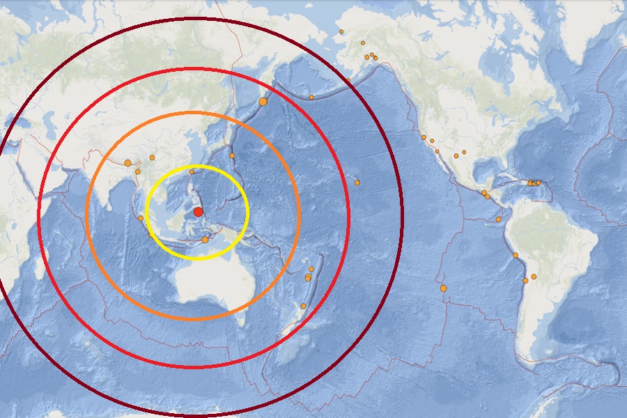
According to USGS, at 23:37 UTC, the magnitude 7.8 earthquake struck 24 km west-southwest of Burias in the Philippines. The earthquake had a depth of 35 km, with the epicenter located under water not far from the coast in the Celebes Sea.
“Based on all available data, there is a threat to Guam, Rota, Tinian, and Saipan of sea level fluctuations and strong ocean currents that could be hazardous along beaches, in harbors and in coastal waters. The earliest estimated time that hazardous sea level fluctuations and strong ocean currents may begin in Guam, Rota, Tinian or Saipan is 12:45 pm CHST on Monday, June 8,” warns the National Weather Service Pacific Tsunami Warning Center (PTWC) which has placed those areas under a Tsunami Advisory.
While a threat exists to Guam and nearby areas, the PTWC adds, “There is no tsunami danger for the U.S. West Coast, British Columbia, or Alaska.”
The PTWC initially said it was too soon to determine whether there is a threat to Hawaii. They wrote in a bullet sent to Emergency Management in the State of Hawaii, “A tsunami threat exists for parts of the Pacific located closer to the earthquake. But it is still too early to determine whether there is a possible tsunami threat to Hawaii. If there is a tsunami threat to Hawaii, the earliest estimated time the hazard might begin is 11:57 pm (tonight.)” But they have since issued an update saying, “Based on all available data, there is no tsunami threat to Hawaii.”
The PTWC believes tsunami waves reaching 3-9 feet above the tide level are possible along some coasts of the Philippines. Tsunami waves reaching 0.3 to 1 meter above the tide level is possible for some coasts of Indonesia and Malaysia. Tsunami waves are forecast to be less than 0.3 meters above tide level for the coasts of Chuuk, Guam, Japan, Kosrae, Marshall Islands, Nauru, Northern Marians, Palau, Papua New Guinea, Pohnpei, Solomon Islands, Taiwan, Vanuatu, Wake Island, and Yap.
