Blizzard conditions with heavy snow accumulating upwards of 1-3 feet could be possible next weekend across the northeast from New Jersey and Pennsylvania north and east into New England, if the latest computer forecast model run from the American GFS is correct. Above and beyond a storm system that will impact portions of the Mid Atlantic this weekend into Monday, which has prompted the National Weather Service to issue Watches and Warnings, eyes are already looking ahead to next weekend where a coastal storm could take shape.

Before then, though, people in the eastern United States need to deal with snow and ice from a storm system moving through now. The storm is taking shape now near the Texas Panhandle and Oklahoma. Below average temperatures already in place across a broad swath of the Central Plains to Midwest will be met with increasing ascent ahead of a potent mid-level low to track from Kansas tonight, to Virginia/North Carolina on Monday. At the surface, as the low tracks essentially due east toward the East Coast over the next 48 hours, mixed precipitation over portions of Kansas and southern Nebraska will changeover to all snow during the day on Sunday as winds increase from the north. The combination of blowing snow and wind gusts to 40 mph will result in significantly reduced visibility and blizzard conditions at times from Kansas into portions of the lower Missouri River Valley.
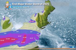
Snow, heavy at times, along with sleet and freezing rain will push east on Sunday and Sunday night through the Ohio Valley into the Mid-Atlantic region. Freezing rain and bands of heavy snow will result in severe travel delays along the storm’s track. Snowfall of 6″ to over 12″ is expected to the north of I-70 from near Salina to St. Louis. A swath of heavy snow exceeding 15″ from northeastern Kansas into north-central Missouri would be the heaviest snowfall in a decade. A stripe of 6-12″ is expected to impact locations between I-70 and I-64 across the Ohio Valley with mixed precipitation along the southern edges. An elongated path of freezing rain accumulations in excess of 0.25″ is likely from southeastern Missouri into central Kentucky with potential for 0.50″ which would result in widespread tree damage and long-lasting power outages. Moderate to locally heavy snow is expected to reach the northern Mid-Atlantic region Sunday night with a wintry mix expanding from the central Appalachians to central/eastern Virginia.
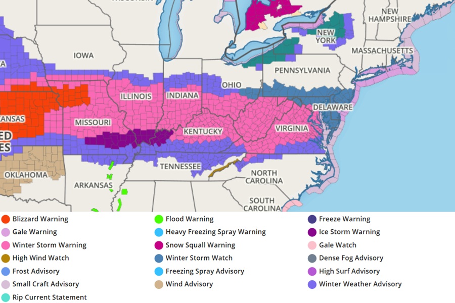
Due to this storm, the National Weather Service has issued Blizzard Warnings for portions for Kansas and Missouri, Winter Storm Warnings from Kansas to Maryland, and Winter Storm Watches from Ohio to New Jersey. An Ice Storm Warning is also up for portions of southern Missouri, Illinois, Indiana, and western Kentucky where significant accumulations of ice are possible.
This initial snowstorm will drop only light snow in the New York City metro area, but significant snow as you head south towards Washington DC where 6-12″ of snow is possible. Because this storm system is heading due east out to sea, it won’t have the opportunity to intensify and curve up along the New England coast. Because of that, little to no snow is expected north and east of New York City, with the exception being some lake-enhanced snows down-wind of Lake Erie and the highest elevations of northern New York, New Hampshire, and Vermont.
But with another system forming later in the week, the areas not getting any snow with this first storm could be hit hard with very significant snow that could be measured in feet rather than inches.
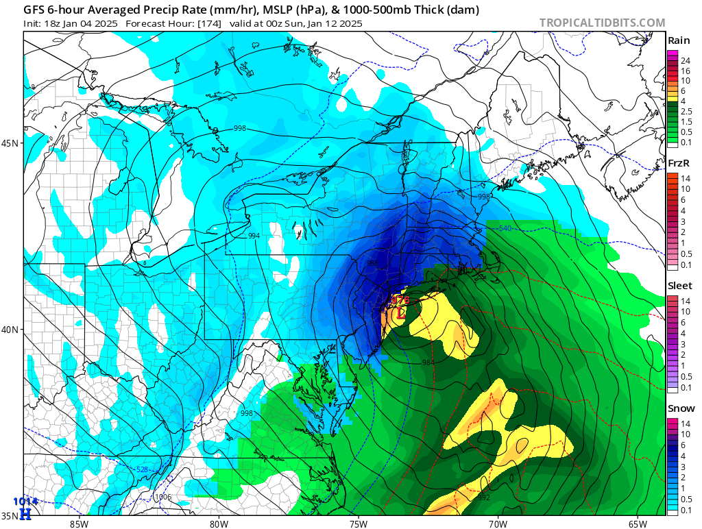
A leading computer forecast model, the American GFS, used by meteorologists to aid with their weather forecasting is suggesting the possibility of a hefty coastal snowstorm next weekend. It shows an area of low pressure rapidly intensifying off of the east coast; with plenty of cold air to work with, it drops snow as far south as Virginia and the North Carolina mountains. If this model run were to verify, southern New Jersey would see about 6″ of snow but central and northern New Jersey and adjacent eastern Pennsylvania could see a foot or more. Across portions of Connecticut, Massachussetts, and southern Vermont and New Hampshire, more than 2 feet could be possible if this forecast model were to verify.
The GFS and ECMWF are among many computer models meteorologists use to assist in weather forecasting. While meteorologists have many tools at their disposal to create weather forecasts, two primary global forecast models they do use are the ECMWF from Europe and the GFS from the United States. While the models share a lot of the same initial data, they differ with how they digest that data and compute possible outcomes. One is better than the other in some scenarios, while the opposite is true in others. No model is “right” all the time. Beyond the ECMWF and GFS models, there are numerous other models from other countries, other academic institutions, and private industry that are also considered when making a forecast.
The latest ECMWF model agrees with the GFS that there will be a significant east coast storm, but it has the storm track a little more north than the GFS with intensification happening later in its path. If that were to verify, there would be less snow for the New York City metro area and points south, but very heavy snow could fall across much of New England.
It is still too soon to say with certainty how this next storm will evolve. People need to deal with the first storm moving through this weekend and the early part of the week; but they also need to be aware there is a threat of an even larger storm arriving at the end of the week into the new weekend.
