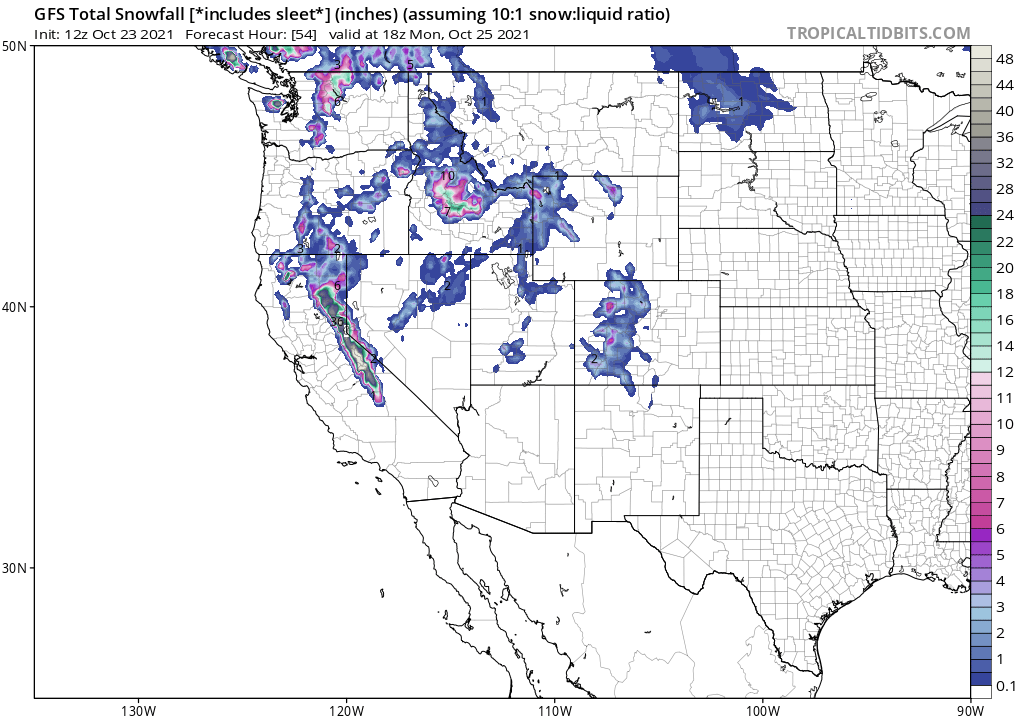
An “atmospheric river” phenomena is forecast to bring an incredible amount of moisture to the Northwest in the coming days, bringing heavy rain and snow to the region. With an area of low pressure expected to rapidly intensify and deepen, it’ll take on characteristics of a “bomb cyclone” later tomorrow into early Monday. By Tuesday, several inches of rain are expected to fall over lower elevations while more than 4 feet of snow will fall over the mountainous terrain.
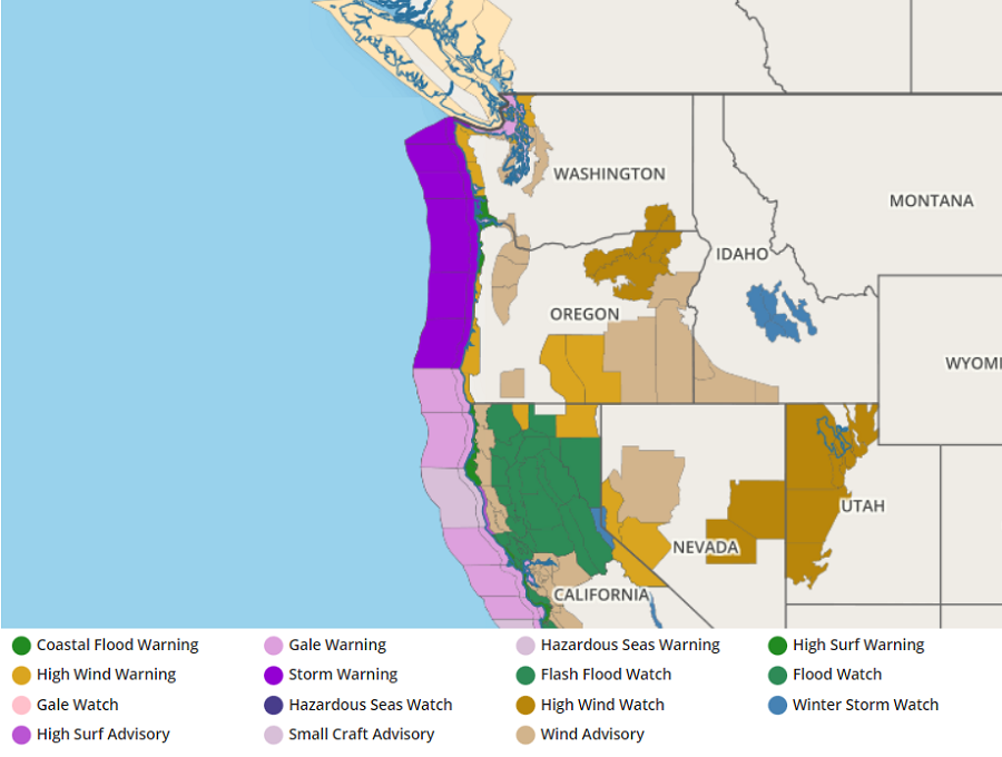
A bomb cyclone is a meteorological term for a storm system that undergoes a period of rapid intensification. A process called bombogenesis can occur when a mid-latitude cyclone intensifies rapidly over a 24-hour period, dropping at least 24 millibars of atmospheric pressure. For a more typical non-bomb cyclone, an area of low pressure could fall 10-15 mb in the same period. Generally the more the pressure drops, the more severe the storm; these systems moving on-shore can bring damaging winds, heavy precipitation, and the threat of coastal flooding and surge.
An atmospheric river refers to a narrow stream of concentrated moisture in the atmosphere. The most common atmospheric river event is nick-named “Pineapple Express”; in this type of situation, a robust stream of moisture near the Hawaiian islands flows north and east into western North America, dropping copious amounts of rain and snow as it interacts with the terrain there. These long, narrow atmospheric rivers help transport moisture from the tropics, in water vapor form, to areas far from the tropics. The liquid equivalent of these moisture plumes could be comparable to the water flowing through the mouth of the Mississippi River, according to NOAA.
On Sunday, the associated front tied to this bomb cyclone will move into the West Coast, advancing inland to the Northern High Plains to the Great Basin/Southern California by Monday evening. Moisture will stream into Central/Northern California overnight Saturday, turning into a powerful stream of moisture on Sunday. On Monday, the moisture stream will move southward along the coast while weakening. As the moisture stream increases, the National Weather Service’s Weather Prediction Center has issued a High Risk of excessive rainfall over parts of the Sierra Nevada Mountains on Sunday into Monday morning. With the High Risk, significant, and potentially life threatening flash flooding is expected.
On Monday, the excessive rainfall threat lessens to a “Slight Risk” category over parts of the Sierra Nevada Mountains with a Marginal Risk over other parts of the Sierra Nevada Mountains and parts of the Southern California Coast from Monday into Monday night. Heavy snow will develop over the higher elevations of the Sierra Nevada Mountains on Monday as the front moves pass by. Furthermore, on Monday, spotty snow will develop over parts of the Cascades and the Northern Intermountain Region Rockies.
On average, 30-50% of annual precipitation on the U.S. West Coast occurs from a few atmospheric river events. In addition to replenishing water supplies, they can also create problems associated with heavy precipitation: flooding, rock/mud slides, and avalanche dangers.
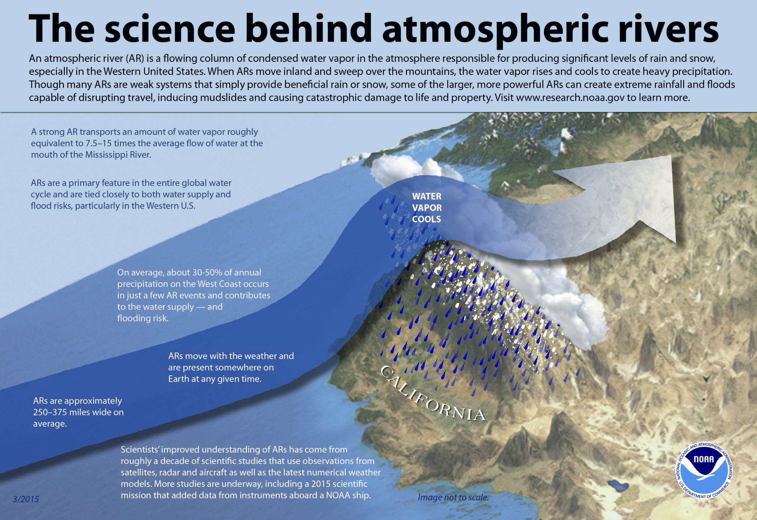
As the stream of water vapor hits the mountain ranges over the U.S. west coast, the air rises, cools, and condenses the moisture out of it. This condensed moisture falls out of the sky as heavy rain, heavy snow, or both.