After a much needed break from a very wet weather pattern, it looks like the Mid Atlantic will be dealing with another stretch of cloudy, rainy days. Worse, it appears the rain returns in time for the weekend. With weekends of the Summer of 2018 running out, another wet weekend forecast will make many sad or angry.
Driving the sadness and anger is a stubborn wather pattern that has generally kept the west hot and dry while it’s kept the east wet and muggy. Global weather forecast models, such as the American GFS, don’t expect much to change with the general weather pattern for the next two weeks. While not every day will be a rainy one, more days than not will feature shower and storm activity.
Friday will be a good summer weather day for outdoor activity in portions of the Mid Atlantic before things make a turn for the wet. With warm sunshine and readings into the 90’s well up the east coast, Friday will be the last fair weather day before wet weather returns. While there may be very scattered showers and storms in the afternoon heating on Friday, a better chance of rain will exist over the weekend and into the new week.
As a cold front approaches the Mid Atlantic on Friday, the flow aloft will becomes more parallel to it, slowing it down. Beyond slowing down, the front is likely going to stall out near the East Coast. A potent vorticity impulse is forecast to move across the region Friday night into Saturday. This is expected to lead to a period of enhanced chances for showers and thunderstorms. With moisture building, moderate to heavy rain is possible with any showers or thunderstorms that form. There is not a significant amount of instability, but there is enough to keep thunderstorms in the forecast. With a lack of atmospheric steering currents, where storms and showers pop-up could do so repeatedly there through a process called “training.” With thunderstorms and rain showers soaking the area over and over and over again, flood problems could be an issue.
By Saturday night and Sunday, the trough near the Great Lakes develops into more of a cutoff low to our west. With the cutoff low there, the front near or offshore of the east coast is not forecast to make much progress over the weekend into Monday, while additional areas of low pressure develop and move along the boundary. Multiple short wave/vorticity impulses will round the cutoff low and move across the region, which will continue to deal with persistent showers and storms. By Tuesday, the trough and cut-off low will begin to leave the region. A surface low will develop as the upper low departs, bringing another chance of showers on Tuesday before a break in the wet weather pattern returns on Wednesday.
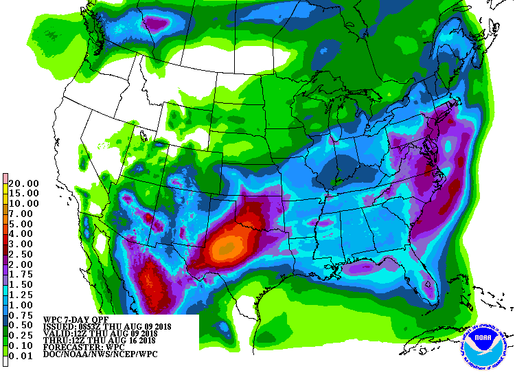
Before then, though, the National Weather Service Weather Prediction Center is calling for more soaking rainfall amounts. 2″ or more is possible from eastern South Carolina north into the New York City metro area and southern New England. Many locations here continue to recover from very heavy rains that fell in July.
The National Weather Service reminds everyone to “turn around, don’t drown; never drive through flood waters.” For additional flood safety information, visit our Flood Information Center here.
Want a cute rain jacket for kids to wear in this wet weather patten? It’s available for sale here.