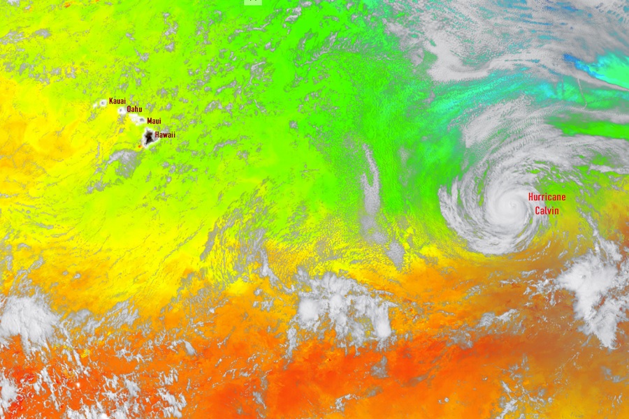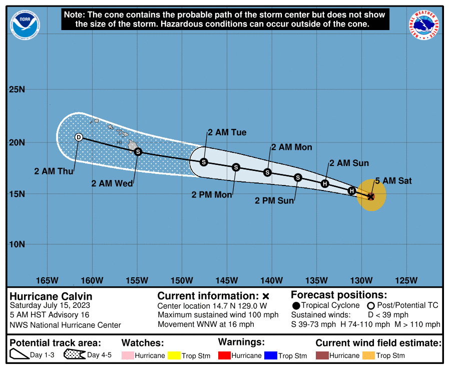
Hurricane Calvin continues to inch closer to Hawaii and is likely to strike it as early as Tuesday night, albeit in a weakened state. There are no watches in effect for Hawaii at this time, but that could change by Sunday night or Monday morning ahead of Calvin’s arrival on the Big Island of Hawaii. It is still too early to know the exact place Calvin will strike and what specific problems it’ll create for Hawaii; however, officials are urging people to become aware and prepared for the storm.
Hurricane Calvin moved over very warm water yesterday while in an environment of low atmospheric sheer. This lead to a period of rapid intensification where it became a Major Hurricane with winds sustained at least 120 mph. Now the storm is moving over cooler water and will continue to move over water that is colder yet. Because heat from warm waters is the primary energy source for these storms, Calvin will continue a weakening trend as it approaches Hawaii. In addition to colder sea surface temperatures, Calvin will also enter an area of increasing atmospheric sheer which will begin to tear at its structure. This too will help weaken it before arriving in Hawaii.
The National Hurricane Center is forecasting that Calvin will strike the east coast of Hawaii as a tropical storm. While not nearly as catastrophic as a landfalling hurricane, tropical storms in Hawaii can be more severe than those along the U.S. East and Gulf Coasts due to the terrain. Hawaii Island’s dramatic volcanic peaks which soar to nearly 14,000 feet are unlike anything on the U.S. Mainland coast; they will help wring out copious amounts of rainfall out of a very moist airmass from the storm; they will also help shape and direct wind flow, especially in downslope areas, with potentially damaging wind gusts.
While Calvin will likely bring beneficial rains to Hawaii, especially on the windward, eastern side of the islands, Calvin may create warming, drying, downslope winds, especially on Hawaii Island’s west coast, which in turn could increase fire weather conditions there. This occurred in previous tropical cyclone impacts in Maui in which wildfires burned on the western side of the island in dry conditions while the eastern side was soaked with flooding rains.

Even a storm below hurricane strength as a tropical storm can bring significant damage to Hawaii. In August of 2014, Tropical Storm Iselle hit the Big Island of Hawaii in the island’s southern Ka’u district. Meteorologically, the storm rapidly fell apart, quickly becoming only a remnant area of low pressure the day after landfall. Nevertheless, Iselle brought significant damage to Hawaii. While hurricane strength gusts were recorded at Mauna Kea on the Big Island, the entire state except for Niihau experienced tropical storm force wind gusts of over 39 mph. Strong winds knocked down large trees and powerlines and unroofed homes around Hilo. Parts of the Big Island saw more than a foot of rain which produced considerable flooding and flood damage. 6-10′ swells pounded the eastern shores of the Hawaiian Islands. More than 1,000 coffee trees, over 2,000 macadamia nut trees, and more than 60% of the state’s papaya crop were badly damaged or destroyed. Over 250 property owners reported damage to their homes with 11 totally destroyed and 28 with major damage. The overall damage toll was pegged at about $325 million, making it one of the most costly natural disasters to strike Hawaii after 1992’s Hurricane Iniki and 1982’s Hurricane Iwa. Iselle was responsible for one death: a 19 year old woman was swept away by flood waters while hiking around in a closed state park.
According to the latest advisory from the National Hurricane Center in Miami, Florida, Hurricane Calvin is located roughly 1,750 miles east-southeast of Hilo and 1,820 east-southeast of Kailua-Kona on the Big Island of Hawaii. The storm, now with maximum sustained winds of 100 mph, is moving west-northwest at 16 mph; minimum central pressure is up to 975 mb or 28.80″.
This weekend Calvin is expected to cross over from the Eastern Pacific hurricane basin to the Central Pacific hurricane basin; when that happens, the National Hurricane Center in Miami will transition the forecasting and advisory issuance of this storm to the Central Pacific Hurricane Center located in Honolulu on the Hawaiian island of Oahu.
National Weather Service meteorologist and hurricane specialist Tom Birchard, based at their Honolulu office, provided some thoughts in the latest Forecast Discussion issued by the office. Birchard wrote, “The official forecast track has been fairly consistent in bringing Calvin very close to, or over, the main Hawaiian Islands Tuesday night and Wednesday. Some questions remain as to the intensity, but vertical wind shear is expected to increase as it nears the islands, with Calvin on a gradual weakening trend during its closest point of approach. Like most systems approaching Hawaii from the East, strongest winds are expected to be in the northern semicircle.” Birchard also called out details that need to be ironed out in the coming days. “Considering typical forecast track errors, it remains too soon to be specific as to where and what – if any impacts occur over land, which will be highly dependent on the track,” Birchard wrote. “If the center were to pass north of the islands, most of the strong winds would remain offshore, with a more southerly track potentially putting the islands in a stronger wind field,” Birchard added.
“As a reminder, tropical cyclones can bring the triple threat of strong winds, heavy rainfall and high surf. The forward speed of the tropical cyclone, forecast to be near 18 mph, should preclude widespread flooding impacts for an extended period of time, hence we’ve decided that a Hydrologic Outlook is not warranted, although a Flash Flood Watch may be issued for parts or all of the state early next week.”
Although the storm is expected to continue weakening before reaching the eastern islands, Hawaii’s emergency managers urge members of the public to make plans and take steps to reduce the possible impacts of the storm on our people and property.

“We’re still hopeful that Calvin won’t cause any major problems, but after three quiet hurricane seasons we don’t want people to be complacent about this hazard,” said James Barros, Administrator of the Hawai‘i Emergency Management Agency (HI-EMA).
“Even if it weakens as expected, the storm still poses potential threats from heavy rain, high wind and coastal waves and rip currents,” Barros said. “Don’t be caught unprepared.”
“We all need to shake off the rust from those slow seasons to be sure we’re prepared for a hurricane,” Barros said. “We’re not sure what Calvin will bring, but it’s still a great reminder of what we need to do to get ready.”
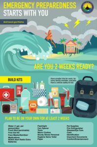
As Calvin inches closer to Hawaii, HI-EMA recommends that people throughout Hawaii take steps to prepare for the storm’s potential arrival. People should sign-up for emergency alerts from their county; each county provides txt and/or email alerts for dangers from tropical cyclones and more. HI-EMA also recommends that people check around their homes and businesses for tree branches that need trimming or other objects that might become damaging projectiles in a high winds. Over the weekend, it is a good idea to secure lanai furniture and other items that could become airborne. Any obstructions in drainage areas should be cleared and in flood prone areas, people should consider getting sandbags ready to channel water away from doing harm. In addition to creating a Hurricane Action Plan, HI-EMA recommends that everyone in Hawaii have at least 14 days of food, water, medicine, and other essentials for themselves and their pets. Ports may become damaged or ships may become detoured, forcing delays of regular supplies and groceries from reaching stores.