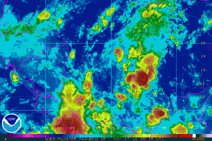
A tropical disturbance east of Central America is struggling to develop into a tropical cyclone. As a result of that struggle, the National Hurricane Center has slightly lowered odds that a system will form here over the next 5 days.
Cloudiness and showers over the southwestern Caribbean Sea are associated with a broad low pressure area. This system has become a little less organized since yesterday. However, environmental conditions are expected to be conducive for slow development during the next several days, and a tropical depression could form over the weekend or early next week while the low moves slowly and erratically.
If this system ever grows further into a Tropical Storm, it would be named Otto.
Where it goes is as tricky to forecast as its future intensity. Forecast models used by meteorologists are split on where this system may travel over time, with some suggesting a drift to the north and east and other suggesting a drift into Central America to the west. Even if the system doesn’t hit Central America, locally heavy rain will continue to fall there from tropical showers in the region.
Visit our Tropical Weather Page here for further information about this system and a review of all tropical cyclones that were near US waters for the 2016 season: https://weatherboy.com/hurricanes-tropical-weather/