An absolute catastrophe continues in the Bahamas with more than 9 hours of fierce category 5 winds blasting away buildings and trees as a storm surge greater than 20′ submerges most islands near the eye of Hurricane Dorian. 3-4 feet or more of rain is falling, adding to the misery there. After stalling overnight over Grand Bahama Island, the storm is ever so slowly lifting away, inching closer to the U.S. coastline.
Evacuations were ordered from many Florida east coast towns yesterday and the same is true today in South Carolina as thousands flee an area that could see significant storm surge and wind-related damage.

Computer forecast guidance suggests the eye will remain off-shore for quite some time, with a possible landfall over the Outer Banks of North Carolina later this week followed by another possible landfall near Nova Scotia at the end of the week. However, a wobble to the left by the storm could bring treacherous high winds and heavy rain on-shore to populated coastal communities. A difference in track by just 10 miles could be catastrophic for some while saving others.
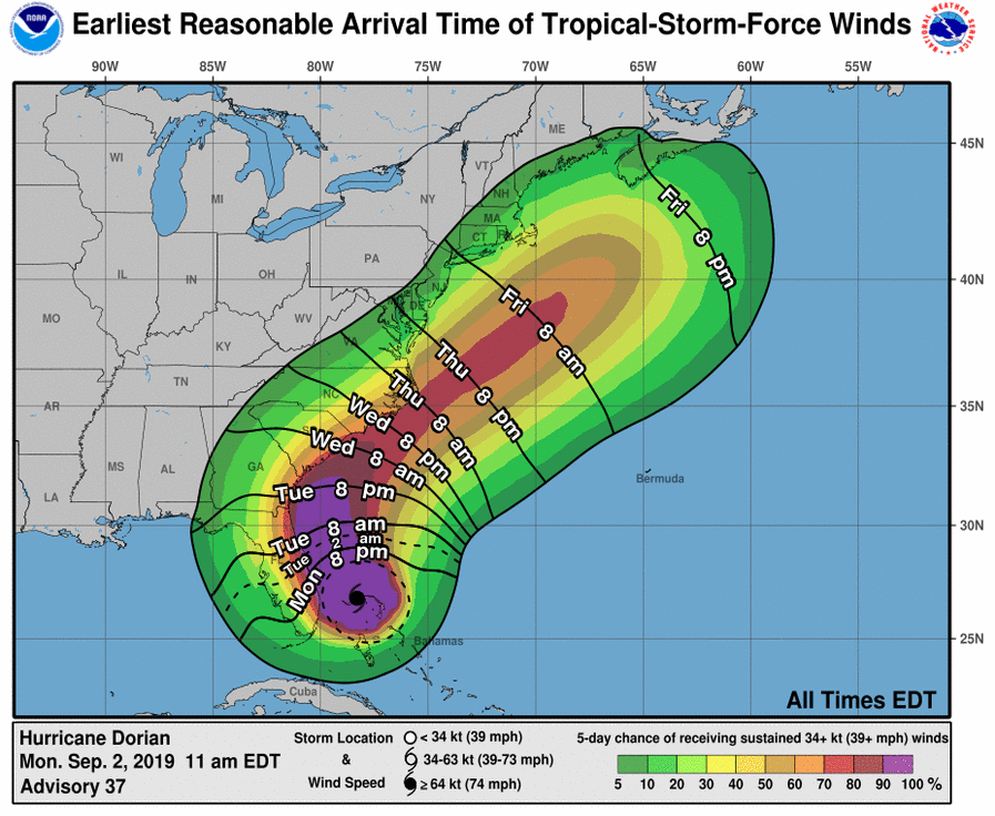
This afternoon, the Miami, Florida-based National Hurricane Center has 4 key messages to share with people around Hurricane Dorian: First, a prolonged period of catastrophic winds and storm surge will continue to affect Grand Bahama Island through today and tonight. Everyone there should remain in shelter and not venture into the eye. Second, life-threatening storm surge and dangerous hurricane-force winds are expected along portions of the Florida east coast and Georgia coast, regardless of the exact track of Dorian’s center. Water levels could begin to rise well in advance of the arrival of strong winds. Residents in these areas should follow advice given by local emergency officials. Third, the risk of life threatening storm surge and hurricane-force winds continues to increase along the coasts of South Carolina and North Carolina. Residents in these areas should follow advice given by local emergency officials. Fourth, heavy rains, capable of producing life-threatening flash floods, are expected over northern portions of the Bahamas and coastal sections of the Southeast and lower Mid-Atlantic regions of the United States into Friday.
Up the coast, the National Hurricane Center encourages people to wrap up storm preparations and be at the site you plan to be for the duration of the storm prior to the arrival of tropical storm force winds. In tropical storm force winds, it becomes dangerous to be outdoors and becomes too difficult to safely drive.
