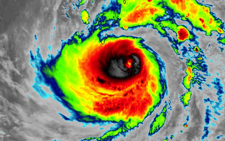
A catastrophic landfall of a Super Typhoon with category 5 hurricane force winds is expected today on Guam, a US territory in the Pacific. In addition to being home to a key military base, Andersen Air Force Base, Guam is home to 170,000 Americans all who are in the path of the most intense tropical cyclone to hit the U.S. since Hurricane Michael hit the Florida panhandle in 2018. Hurricane Ian which brought catastrophic destruction to Fort Meyers, Sanibel and Captiva Islands, and surrounding communities last year was only a Category 4 storm when it made landfall.
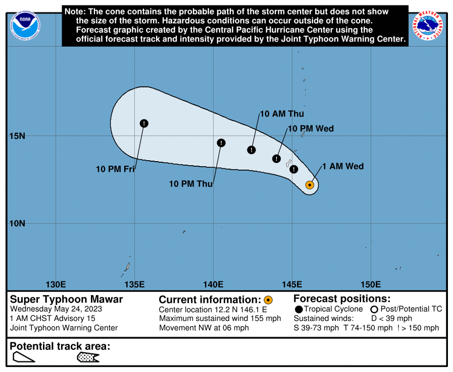
According to the National Weather Service office at Tiyan, Guam, Super Typhoon Mawar was moving northwest at 5 mph towards Guam. Maximum sustained winds are at 155 mph and its intensity is forecast to be about 160 mph as it plows through Guam as a category 5 storm on the Saffir-Simspon hurricane wind scale. Typhoon force winds extend outward from the center up to 40 miles. Tropical storm force winds extend out from the center up to 140 miles. The center of the storm is about 110 miles southeast of Guam.
Absolutely terrifying for Guam.#SuperTyphoonMawar pic.twitter.com/1StwKcJK7z
— the Weatherboy (@theWeatherboy) May 23, 2023
A Typhoon Warning remains in effect for Guam and Rota while both a Tropical Storm Warning and Typhoon Watch are up for Saipan and Tinian.
The National Weather Service says that the triple threat of a significant typhoon is becoming increasingly likely for Guam, and to a lesser extent, Rota, with torrential rains, winds well over 100 mph and significant storm surge. Rains may exceed 15″ with rain rates of 7″ per hour possible within the eyewall. “Widespread impactful flooding is possible, with landslides a distinct possibility for central and southern Guam,” the National Weather Service warns.
“Considerable damage is likely for buildings and homes constructed of light materials. Power poles may fall, even hollow-spun concrete poles. Cars could be overturned. Trees may fall and be severely defoliated. Roads may be impassable due to fallen trees. Power may be out for an extended period of time.” Winds gusting to 170-200 mph are possible.
The National Weather Service says the greatest concern for storm surge would be a passage over or just south of Guam as this places the greatest surge into the vulnerable parts of Inalahan, Malesso and up to Ipan and Pago. The northern eyewall could potentially bring storm surge up to 15 feet above the normal high tide if the ingredients align. Western coastlines could see surge up to 4 feet if the center goes over or just north of Guam. For now, it appears the worst case scenario is the most likely to unfold.