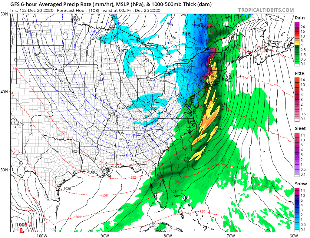
While portions of the northeast continue to dig out of the three and a half feet to four feet of snow that fell only days ago, it appears a new system will be pushing through the eastern U.S. in time for Christmas Eve and Christmas Day. However, unlike the nor’easter responsible for the heavy snow last week, the Christmas event won’t come in coastal storm form.
And while many are hoping for a White Christmas 2020, it appears much of this precipitation will be wet rather than white. With Christmas still days away, though, there are differences among the computer forecast model output that aids meteorologists with their weather forecasting. The Canadian and American forecast models have a fast-moving, strong cold front moving through the East Coast by daybreak Christmas morning, with most precipitation falling during the Christmas Eve overnight hours. The European forecast model, though, isn’t as fast, and brings the cold front across the region later in the day Friday. While it does start east coast precipitation on Christmas Eve, the bulk of it falls on Christmas day.
Ahead of the front, temperatures will rise above freezing, even in areas that have snow cover today. With above freezing temperatures, any precipitation that falls will be in liquid form there. Cold air will rush in behind the frontal passage, helping change rain to snow. However, in addition to being colder air, it is also significantly drier air. Because of the dry air intrusion, there won’t be much precipitation left to work with to generate significant snowfall after frontal passage. Because the airmass is rich with moisture ahead of the front, some of the rain, though, could be heavy at times up to the point of frontal passage. Unlike a heavy snow threat from the last storm, rain could be heavy enough this time around to create flooding problems, especially near the I-95 corridor.
New England could pick up a few inches of snow from this frontal passage. Little to no snow is expected south into the Mid Atlantic, even if rain does change to snow before ending there after frontal passage.
The strong front will also bring strong winds. Strong winds may tamper with outdoor holiday decorations. Winds may also be strong enough to knock down tree branches or wires, resulting in some scattered power outages on Christmas Day, especially in the Mid Atlantic and Northeast.
The weather system will clear out relatively quickly, producing a fair, dry, and cold period for at least the next 24 hours. While this will dry out much of the east, it will help trigger some narrow bands of lake effect snow in portions of the northeast.
