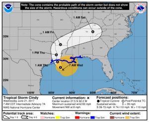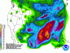
Tropical Storm Cindy is impacting the Gulf Coast, bringing copious amounts of rain with it from the Gulf of Mexico. While the center of circulation of this ill defined tropical cyclone is expected to come on-shore near the Texas/Louisiana border, most of the precipitation associated with it is on the eastern half of the storm. The same is true with its maximum wind field, located in a relatively small pocket on the east side of the storm. As such, the impacts from this storm will be felt far east from where it actually is, bringing flooding problems as far east as Florida.
In the last advisory from the National Hurricane Center, Cindy is moving toward the northwest near 8 mph and this motion is expected to continue today. A turn toward the north-northwest and then toward the north is expected later today and early Thursday. On the forecast track, the center of Cindy will approach the coast of southwest Louisiana and southeast Texas late today or tonight, and move inland over southeastern Texas or southwestern Louisiana on Thursday.
Maximum sustained winds remain near 60 mph with higher gusts. Little change in strength is expected today. Slight weakening is forecast to begin on Thursday. Tropical-storm-force winds extend outward up to 275 miles, mainly north through northeast of the center.
The minimum central pressure recently reported by an Air Force Hurricane Hunter aircraft was 996 mb (29.41 inches of Mercury).
As of the last advisory. a Tropical Storm Warning is in effect for San Luis Pass, Texas to the Alabama/Florida border, all of metro New Orleans, and Lake Pontchartrain. A Tropical Storm Warning means that tropical storm conditions are expected somewhere within the warning area, in this case within the next 12 to 24 hours.
There are numerous hazards associated with Cindy and it’s approaching landfall:

RAINFALL
Cindy is expected to produce total rain accumulations of 6-9 inches with isolated maximum amounts of a foot or more over southeastern Louisiana, southern Mississippi, southern Alabama, and the Florida Panhandle through Thursday. This rainfall could cause life-threatening flash flooding in these areas. Rainfall amounts of 3-5 inches with isolated maximum amounts of 6 inches can be expected farther west across western Louisiana and eastern Texas through Thursday. Rainfall should spread northeastward across Arkansas and into portions of the Tennessee and Ohio Valleys through Friday, with total rain accumulations of 3-5 inches with locally higher amounts possible.
WIND
Tropical storm conditions are affecting portions of the northern Gulf of Mexico coast over the eastern part of the warning area. These conditions should spread westward within the warning area through early Thursday.
STORM SURGE
Inundation of 1 to 3 feet above ground level is expected along the coast in portions of the Tropical Storm Warning area, with isolated areas possibly up to 4 feet.
TORNADOES:
A few tornadoes are possible this morning through tonight from the western Florida Panhandle to southern Louisiana.