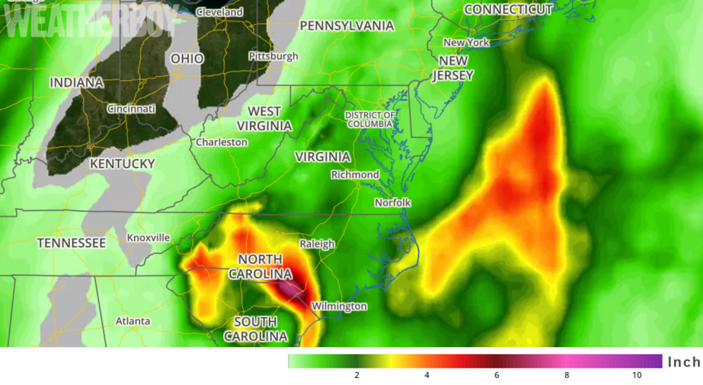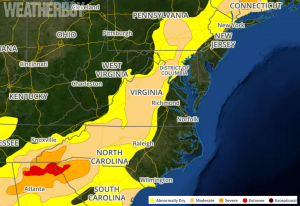
A coastal soaker system will drench portions of the eastern United States this week, with some areas forecast to receive over 6 inches of rain over the next 72 hours. At fault is a complex area of low pressure over the south eastern US that will struggle to exit out of the region anytime soon.
This morning, a strong consolidated upper level low is digging into southeastern Georgia, providing an expansive regime of diffluence and divergence across the Carolinas. This set-up is creating an excellent environment to support broad scale ascent for a large shield of moderate rainfall. It is also creating an environment that favors good evacuation for embedded convective bands. At the surface, a 1004mb low sits northwest of Savannah, Georgia with a warm front stretching up along the North Carolina Outerbanks. Moisture and instability is generally limited to the warm sector behind this front. A line of convection, enhanced by the western edge of the Gulf Stream, extends through eastern South Carolina; a secondary line is also forming between Beaufort, SC to just east of Columbia, SC.
A generally unidirectional cloud-baring flow is near the thunderstorm development region and fanning out further north to the South/North Carolina boarder. This will lead to very heavy precipitation there as showers and storms “train” over the same area repeatedly.

With surface dewpoints in the upper 60s to near 70, continued upstream redevelopment of showers and storms are expected throughout the morning hours today. Fortunately for those in flood prone areas, a variety of atmospheric ingredients will prevent this set-up from taking advantage of a deeper tropical connection that could produce even heavier rainfall amounts. As such, rainfall rates will be heavy at 1.5-2″/hr, but not completely catastrophic. However, given the orientation and persistence of this atmospheric set-up later today, 3-5″ rainfall amounts are possible later today over a 6 hour period from near an area southeast of I-77 and east of I-26, perhaps reaching up into portions of southeastern North Carolina as well. With these heavy showers and storms and hefty rainfall amounts, flash flooding is likely in this region.
Further west, eastern Georgia and western South Carolina will experience a more limited isentropic ascent regime than areas further east. However, given the forecast track of the upper level low moving through the region, some heavy rain shower and thunderstorm cells will be slow to move, particularly later this morning near the Augusta region. While the coverage of showers and storms will be more scattered due to the further limited inflow and instability regime there, flash flooding is possible under those near-stationary cells with amounts of 1.5-3.5″ of rain possible.
Along the North Carolina coast, the greatest uncertainty in heavy rainfall amounts this morning resides along the warm front zone. Strong onshore flow and modest instability from the Gulf Stream environment will be sufficient for convection to fire up. However, with limited focus, thunderstorms that fire here may be weaker and more broken-up reducing flooding concerns in the short-term. However, it is possible with some focused forcing, such as the line currently approaching the Wilmington, NC area, some banded or training convective regimes may form. Should these bands of storms form and repeat themselves over these areas, flooding concerns like those in South Carolina will move north.
Water vapor imagery from weather satellites indicates that the upper low is making very slow progress southeastward into northern Georgia early this morning, with an elongated surface low extending from the South Carolina / Georgia border south-south-east into the Atlantic waters east of Florida. The cutoff upper low is now nearly neutrally tilted and is expected to become slightly negatively tilted today as a jet streak rotates around the upper low. Highly difluent flow will develop just downstream in the Coastal Carolinas and southern Mid-Atlantic. In conjunction with right-rear quadrant jet dynamics from a departing New England jet streak, broad/deep ascent will continue/intensify today along much of the US East Coast. This will foster a gradual intensification of the surface low as it slowly pivots north-northeast along the Southeast Coast.
Strong low-level onshore flow will develop north of the low, with isentropic ascent combining with upslope flow to generate widespread rain and embedded convection along and east of the central/southern Appalachians today. Our region will be on the far northern fringe of
the stronger ascent today, but the upper low will cease its southeastward push today as it acquires the negative tilt. Subsequent to this, the stronger ascent will begin its approach to the DelMarVa area. This will allow for precipitation starting out as light and spotty in the central Mid Atlantic, owing to relatively weak ascent this far north of the low and the relatively dry low levels that will necessitate moistening/saturation for steadier precipitation to develop.
Recent simulations of higher-resolution computer-modeled forecast guidance are bringing in precipitation just a little bit faster as a perturbation ejects northward from the upper low this afternoon. These simulations bring some precipitation as far north as I-195 in New Jersey and I-76 in Pennsylvania as early as 3pm. However, with the low-level air being fairly dry, the better chance for rain in this area will arrive after 6pm.
This slow-moving system will creep up the Mid Atlantic coast this week. The surface low should reach Ocean City, Maryland by midnight Wednesday morning. The rain shield from this low will push north into eastern New England and become heavy at times during the day Wednesday. Between now and then, grey and damp conditions will push up along the east coast as the deluge wraps-up over the Carolinas.
High pressure will make a brief return to the eastern United States on Thursday, giving people a chance to dry out then. However, another frontal system will bring more unsettled conditions to many on Friday and the weekend.