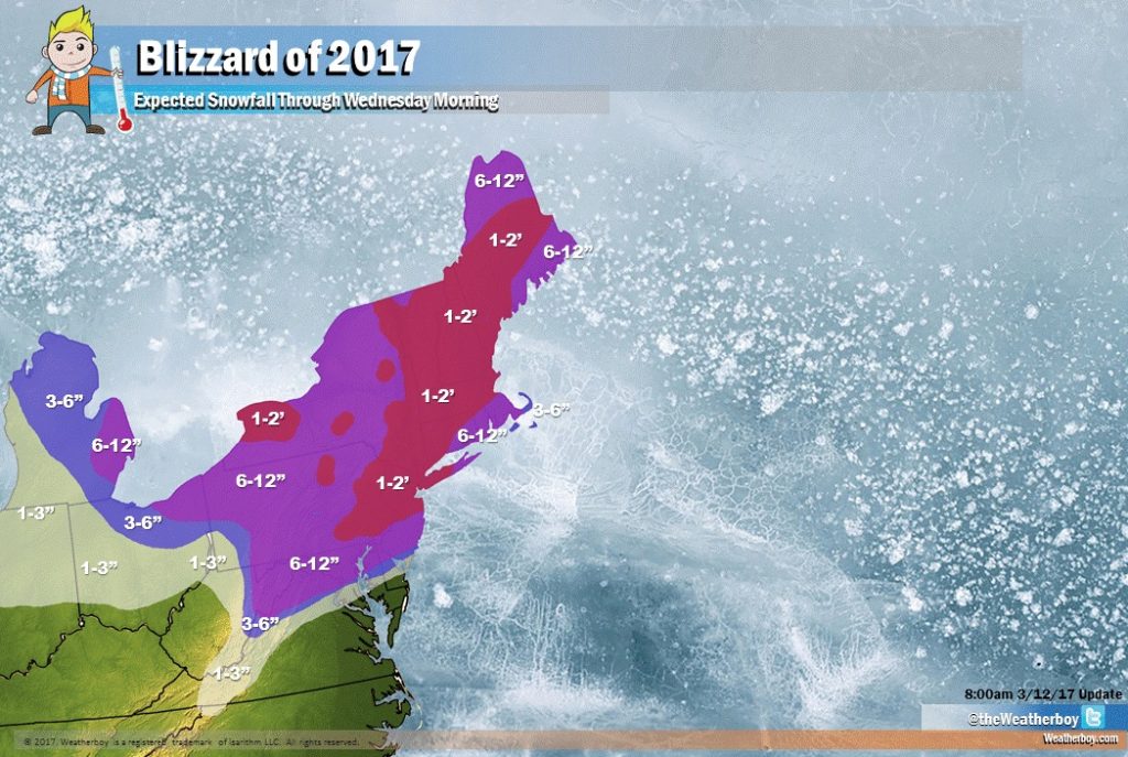
A crippling blizzard will impact the northeast later Monday into Tuesday before wrapping up early Wednesday morning. While heavy snow will fall out of the sky onto many, coastal areas will be impacted by damaging winds, significant high wave action, coastal flooding, and major beach erosion.
High pressure will continue to build into the northeast today, allowing clear skies for much of the region tonight. Some mid-level clouds will begin to move into the northeast late tonight, spilling over from an approaching flat upper ridge. With recent snow covering the terrain over central and northern Pennsylvania and New Jersey, New York, and southeastern New England, along with diminishing winds, temperatures will drop significantly tonight. Expect partly to mostly cloudy skies from New York City and points north and west by tomorrow morning as the flow across the eastern two thirds of the continental US begins to amplify.

Later on Monday, clouds will begin to stream from the south to the north as a developing coastal storm takes shape off the US east coast. Energy arriving from the Pacific Ocean into the Northwestern US this morning will dive into the southern US, eventually phasing with subtropical energy Monday night. This phased energy will track up the coast around digging northern stream energy that’ll take the shape of a developing upper low by the Great Lakes by Tuesday. These systems will eventually phase together as a closed low over the northeastern US Tuesday night into early Wednesday. At the surface, this upper-level scenario will allow for low pressure to develop across the US southeast Monday. This low will intensify as it tracks north towards the Carolina coast Monday evening. It will eventually pass northeast between Montauk Point on Long Island and 40 degrees latitude / 70 degrees longitude known as the “benchmark” area for major northeast storms. By Tuesday evening, this storm will be near Cape Cod as a low pressure system with pressure readings as low as the low 980mbs.
Since last night, computer guidance that meteorologists use to aid in their forecasting has shifted the storm path and structure a bit. These shifts will keep the rain/snow line from moving too far north, while also bringing the heaviest precipitation closest to the coast. The exception to this will be over far eastern Long Island, Block Island, Martha’s Vineyard, Nantucket, and Cape Cod, where mixing with sleet and/or rain will be possible at times as the storm winds up the coast. As such, snowfall accumulations there will be somewhat lower.
In terms of a heavy snowfall, coupled jet structure, approaching mid level shortwave energy, and strong frontogenetic forcing, all interacting with a significant inflow of gulf and sub-tropical moisture, will yield to very heavy snow. In parts of New Jersey and the New York City metro area, there could be some extreme heavy snowfall rates in excess of 2.5″/hour late Monday night through Tuesday afternoon.
Thunder snowstorms will form, leading to isolated bands and cells of extremely heavy snow. As these areas of intense snowfall develop, they will rob nearby areas of moisture. As such, we expect heavy snow pockets to be speckled with areas of lighter amounts around them. Remember: when thunder roars, head indoors! Lightning can kill in any season.
In addition to the shift in storm path and structure is the forward speed of this storm. This storm will be moving along somewhat faster than earlier thought. Because of the speed of the system, it won’t be able to linger around to drop historic amounts of snow. Nevertheless, snowfall will be heavy and crippling for many.

Heavy snow will continue through much of the day Tuesday before wrapping up during the evening hours. A “dry-slot” will be associated with this storm and will aid in shutting off the snowfall. A dry-slot is zone of dry air which wraps east or northeastwards into the southern and eastern parts of a synoptic scale or mesoscale low pressure system and is responsible for creating the comma-like shape of a mature storm on satellite imagery. We will be tracking this development which will also have a negative impact on snowfall amounts. While the dry-slot will lead to diminished snowfall amounts, the area just north of it, nick-named the “comma-head”, will see some of the heaviest snowfall rates and amounts.
While the storm exits the northeast later Tuesday and early Wednesday, snow shower activity will persist for many on the day on Wednesday as winds howl from the northwest. These snow showers may leave additional light accumulations throughout the northeast then.
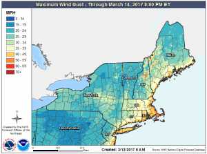
While northwest winds will howl on Wednesday, they will really roar on Tuesday as the storm system takes shape along the east coast. Wind gusts may approach 30mph as far inland as the Delaware/Maryland border and eastern Pennsylvania near Philadelphia. 40mph wind gusts are likely along and east of the Garden State Parkway in New Jersey and across all of Long Island. 40mph+ wind gusts will also be felt across much of Connecticut, Massachusetts, Rhode Island, eastern New Hampshire, and coastal Maine. Across southeastern New England, especially from south of Boston to Block Island, some wind gusts may exceed 50mph.
These winds will topple tree limbs and utility wires, possibly leading to long-duration power outages. There could also be minor structural damage, especially on exposed coastal areas. Everyone, coast and well inland, should secure any outdoor objects that may blow around in gusty winds during the storm. It is these winds that will also create blizzard conditions.
While most people associate a large snow storm with the word “blizzard”, that is meteorologically incorrect. Blizzards are defined by their winds and visibility; it is even possible to have a blizzard without any fresh snow falling. To meet blizzard criteria, bad weather conditions need to persist for more than 3 hours: namely, winds need to be at 35mph or more and visibility due to either fresh falling snow or blowing fallen snow needs to be reduced down to a quarter mile or less.
You don’t need to have blizzard conditions to have dangerous snow storm conditions. Blowing snow is wind-driven snow that reduces visibility. Blowing snow may be falling snow or it could be snow on the ground that is picked up by the wind. Snow flurries are typically defined as light snow falling for short duration with little to no accumulation while snow showers are known for snowfall at varying intensity for brief periods of time with light accumulations. Snow squalls, however, are severe, brief, intense snow showers accompanied by strong, gusty winds, and while short-lived, snow squalls can produce quick and significant accumulations. In and after snow storms, snow squalls can threaten a region with additional hazards.
The heavy snow and strongest winds should begin to wind down from southwest to northeast late Tuesday into early Wednesday as the low pressure pulls east of New England. But with snow showers and gusty northwest winds lingering into Wednesday as the phased upper low moves through, visibility may drop again from time to time in blowing snow.
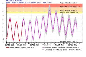
In addition to a damaging wind threat, there is also the threat of significant coastal flooding, especially along the Jersey Shore, the south shore of Long Island, and southeastern New England. Some flooding could be moderate, especially at times of high tide on Tuesday. If you are in a low lying coastal area prone to coastal flooding, take appropriate steps now to protect life and property. As the storm pulls away, there is also a risk of blow-out tides, especially in the back bays of the Jersey Shore.
High and rough surf will also batter beaches leading to significant beach erosion.
Eventually high pressure will build back into the northeast later Wednesday, with fair and dry weather arriving for Thursday.