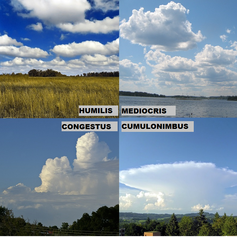
“Puffy white cotton balls in the sky” is one way to describe cumulus clouds.
 The term actually comes from the Latin word for heap or pile which is Cumulo. No matter how you describe it the physics remains the same. These clouds form due to convection or vertical motion in the atmosphere. Typically this occurs during the day due to sunshine heating the air near the surface but can occur at night provided there is another process that initiates the vertical motion given the lack of sunshine. The true classification of clouds does not stop at just cumulus, that would be too easy, there are sub classifications to different types of cumulus clouds. You don’t have to memorize the names of these sub classes (or worse yet, the Latin meaning) but knowing which clouds you are seeing and why can give you an idea of the state of the atmosphere and where it could be headed.
Cumulus humilis (upper left, humilis = humble) are the tamest of the cumulus clouds. These form with a little heating but in a stable atmosphere they will not continue to grow upward. This is the true puffy white cotton ball clouds and if you see these it is likely mid-afternoon. They will be gone around sunset and will not produce any rain.
Cumulus mediocris (upper right, mediocris = moderate) are cumulus clouds which show some vertical development. There is a hint that the atmosphere could be destabilizing a bit and may produce rain, but at this stage it will remain dry.
Cumulus congestus (lower left) are clouds with considerable vertical development. These are easy to point out as they begin to tower into the sky and initially have what looks like a very crisp outline. This is a point where you need to become more weather aware since what is causing those clouds to tower is the atmosphere becoming more and more unstable. You may begin to notice some rainfall falling out of distant clouds or be caught in a shower yourself, but at this point the showers will be brief and probably not all that heavy. One thing to look for is the clouds getting higher and higher as the day goes on since that would indicate the atmosphere is getting more and more unstable which could lead to the Cumulonimbus cloud.
Cumulonimbus (lower right) are mature thunderstorms and form when the atmosphere is very unstable. The air will rise until it bumps the stratosphere where it can no longer rise so it spreads out into the anvil cloud. These clouds will contain very heavy rain, lightning, and the possibility of severe weather. They can for alone, in groups, or develop into a line along a cold front. Given certain situations these cumulonimbus clouds will develop into super cell storms and pose a threat for tornadoes and large hail. Other times the storms simply rain themselves out leaving only high thin clouds behind.
So look up next time your out on a warm summer day. See how the clouds are developing and changing. By observing how the clouds are changing you may be able to predict a future shower or thunderstorm.