The National Weather Service is warning there could be damaging winds along with some light snow and snow squalls on Thursday across portions of New Jersey, Pennsylvania, and Delaware. Due to this threat, there are widespread Wind Advisories in effect not just for these 3 states, but for the area stretching from South Dakota to West Virginia and from New York State into southern New England. However, the winds with the most destructive threat will be over eastern Pennsylvania, Delaware, and New Jersey.
High pressure that was centered over the Appalachians early this morning is sliding off to the south and east as low pressure moves into the Great Lakes region. This strengthening low will track to our north tonight and Thursday, pushing a strong cold front across the Mid Atlantic early Thursday. It is this frontal passage that’ll create most of the problems in this region on Thursday. Cold and dry high pressure will build into the Ohio Valley Friday through Saturday before weakening into the Mid Atlantic through Sunday.
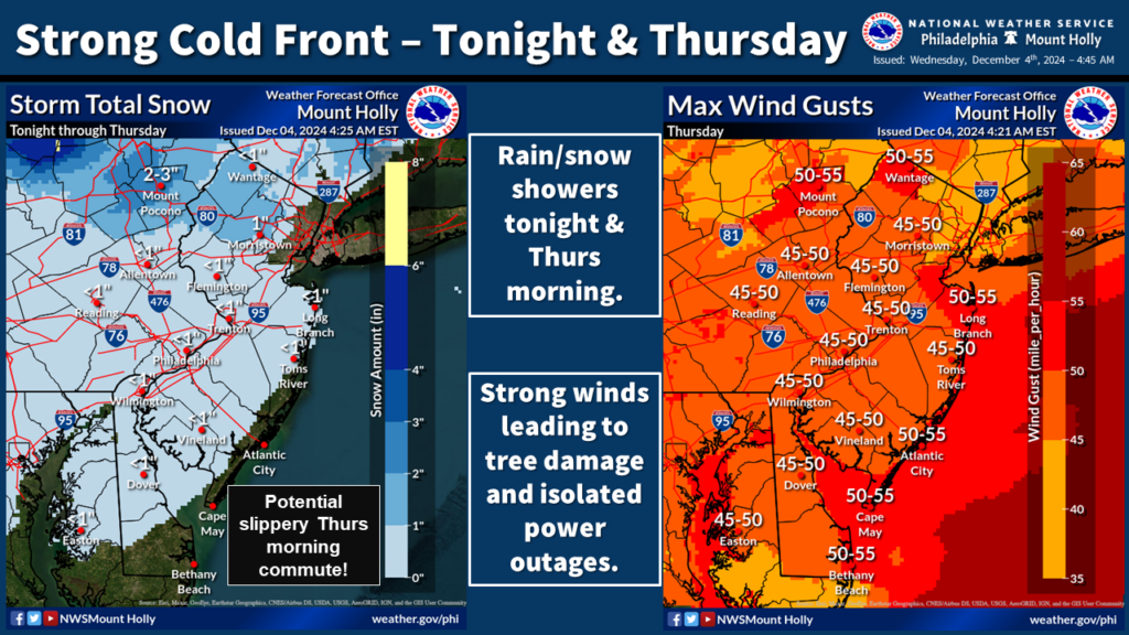
As the Arctic cold front moves through, snow showers and squalls will break out, especially during the morning rush in portions of northern and western New Jersey, eastern Pennsylvania, and the northern half of Delaware. Mainly a dusting of snow is expected, although an inch or two may fall over portions of northern New Jersey and the Poconos of Pennsylvania. Nevertheless, even a dusting of snow could make the morning drive time a slippery one and the National Weather Service urges people to drive with caution.
Beyond the snow shower activity, the big news will be the wind. Winds will gust over 45 mph throughout all of New Jersey, Delaware, and eastern Pennsylvania, with gusts of 50-60 mph possible too. Winds at these speeds can cause damage, taking down tree limbs and wires. People in these areas are asked to secure their outdoor decorations, other outdoor objects such as garbage cans and toys, and prepare for the possibility of power outages.
