Dangerous snow squalls are likely across portions of Pennsylvania, New Jersey, and New York today, including the metro Philadelphia and New York City areas, creating extremely dangerous driving conditions for the areas they strike. Snow squalls could produce sudden, brief, low or no visibility heavy snow bursts, the flash freezing of untreated roadways, and strong wind gusts of 40-50+ mph. Squalls may also make it into western and central Connecticut later in the afternoon too.
The National Weather Service expects snow squalls in this area beginning around mid morning and lasting through the early afternoon hours. A reinforcing arctic cold front is to blame; it is forecast to sweep through the northeast and will be supported by a robust mid level trough and a powerful jet streak aloft, providing ample baroclinic forcing.
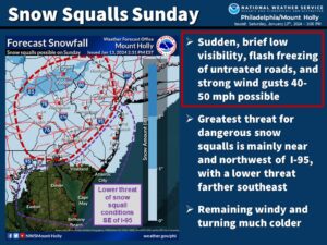
Blowing snow, reduced visibilities, and the potential for a flash freeze are all possible along a line of heavy snow showers along the cold front. Timing for this will begin a few hours after sunrise for eastern Pennsylvania before moving towards the I- 95 corridor by late morning/early afternoon and New York City and western Long Island by 12 noon to 1 pm.
For extreme southern New Jersey and the southern Delmarva, there could be a rain/snow mix by the time the line arrives in the afternoon, but reduced visibilities are still a concern even there.
Temperatures may warm slightly during the morning hours but are expected to tank at the onset of heavy snowfall and behind the arctic front.
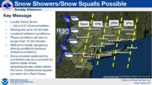
While overall snow accumulations will generally be around an inch or less, snow squalls cause dangerous travel conditions.
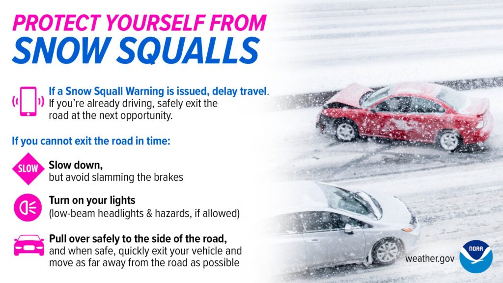
“During a snow squall, the last place you want to be is on the road,” the National Weather Service warns. “The rapid onset of heavy snowfall and strong winds will cause a sudden drop in visibilities, making travel impossible. The heavy snowfall along with an abrupt drop in temperatures could lead to a flash freeze, turning roadways into ice,” they add. “Delay travel if a snow squall warning is issued. If you are caught on the road when a snow squall occurs, use extreme caution, slow down, turn on your hazards, pull over safely to the side of the road, and when safe, quickly exit your vehicle and move as far from the road as possible.”
