• Skip to primary navigation
  • Skip to main content
  • Skip to primary sidebar

Weatherboy

Weatherboy Weather News, Maps, RADAR, Satellite, and Forecasts.

  • Local
  • Earth Science News
  • RADAR
  • Current Warnings
  • Satellite
  • Current Maps
  • Forecast Maps
  • Video

Day of Danger Here

by Weatherboy Team Meteorologist - June 19, 2017

Updated Convective Outlook map from the Storm Prediction Center shows the Enhanced area has stretched a little more east into New Jersey, Delaware, and Maryland than yesterday's version of the same map. Image: Weatherboy.com
Updated Convective Outlook map from the Storm Prediction Center shows the Enhanced area has stretched a little more east into New Jersey, Delaware, and Maryland than yesterday’s version of the same map. Image: Weatherboy.com

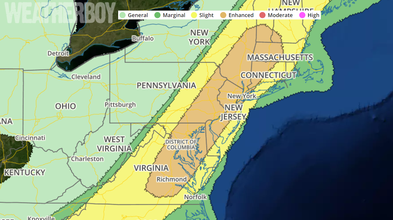
A day of danger is here as a potent frontal system is expected to create a large area of severe and potentially violent thunderstorms over a very heavily populated region in the country. The National Weather Service’s Storm Prediction Center has the I-95 corridor from just south of New York City through the Philadelphia, Balitimore, and Washington DC area, down into central Virginia outline as an area of “Enhanced Risk” of severe storms. This means there’s a substantial threat of severe thunderstorms in this region which could create damaging winds, frequent lightning, flooding rains, large hail, and isolated tornadoes.


A high-resolution, short-duration model, suggests the severe activity will be at its worse between 2pm and 8pm across the Mid Atlantic. This is a simulated RADAR view. Storms may move faster or slower than what is modeled here. Image: TropicalTidbits.com
The National Weather Service has issued Flash Flood Watches (green) for a large part of the Mid Atlantic and Northeast; this region may see floods during the PM hours today as very heavy downpours fall from strong to severe storms. Map: weatherboy.com

The National Weather Service defines a severe thunderstorm as a storm having these characteristics: has measured wind gusts up to or in excess of 58mph, and/or hail to at least 1″ in diameter, and/or spawns a tornado. A thunderstorm doesn’t need to be severe to be deadly; lightning and flash floods from even non-severe storms have claimed lives before.

Storms will be at their most intense after 2pm.  Damaging wind gusts will be the primary severe hazard but large hail is also possible. This type of set-up could also lead to isolated tornadoes, especially over Delaware, eastern Maryland and Virginia, New Jersey, Pennsylvania, and points north.


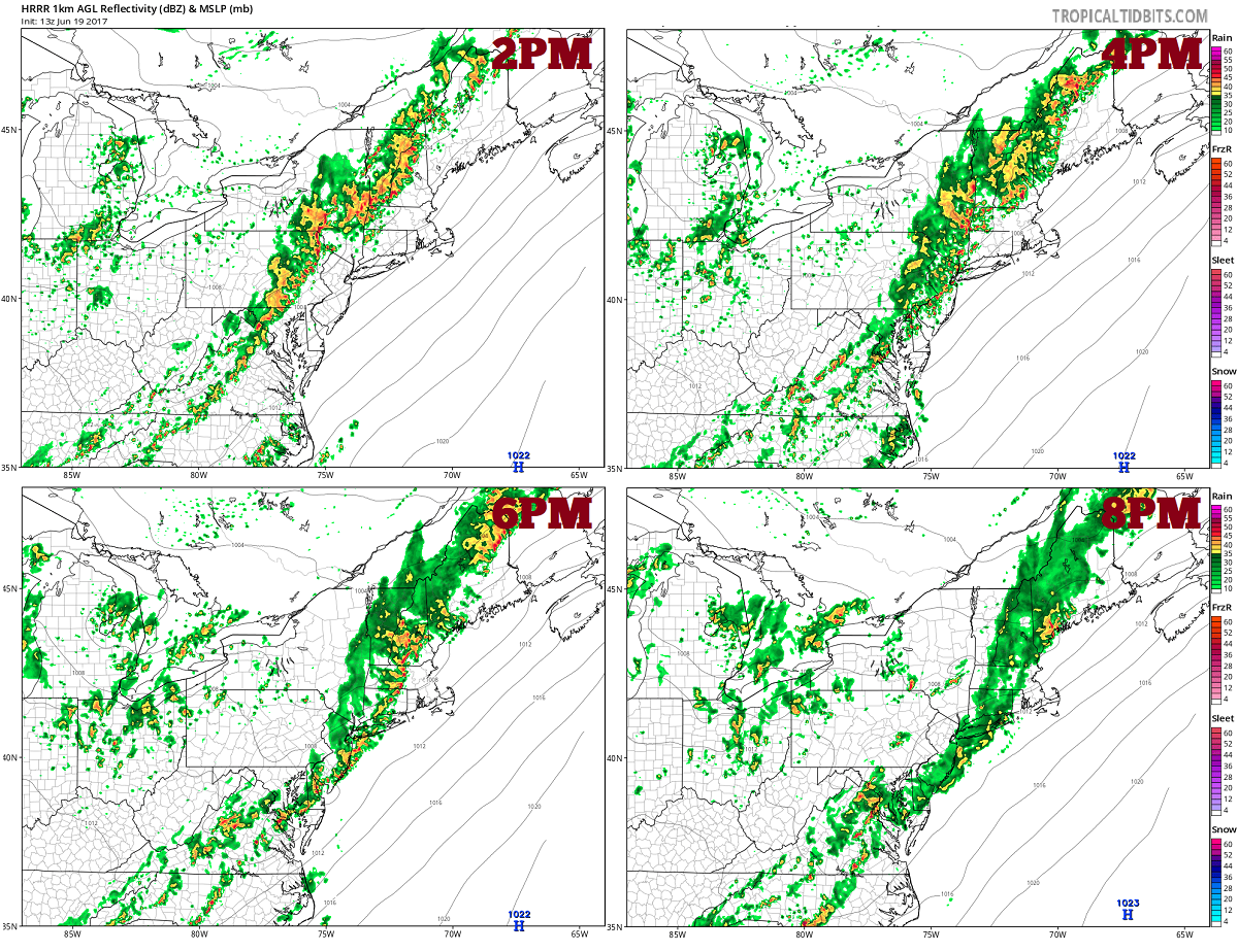
An upper-level trough will move across the Great Lakes and Ohio Valley on Monday as southwesterly mid-level flow remains over the Northeast. At the surface, a cold front will advance eastward across the lower Great Lakes and Ohio Valley. Ahead of this front, surface dewpoints in the mid to upper 60s  should result in a corridor of moderate instability from the Carolinas north-northeastward into the Mid Atlantic. Thunderstorm development is taking place now with a gradual expansion of convective coverage taking place later  in the afternoon. Several line segments may organize along the front moving to the coast of the Mid-Atlantic by early evening.

By 8pm, the line of showers and storms should be pushing off the New Jersey coast, but showers and storms will linger into the overnight areas to the north in New England and to the south over Virginia and the Carolinas.


This weather will likely play a role in today’s scheduled rocket launch from Virginia’s NASA Wallops Flight Facility. There, a rocket is due to lift-off shortly after 9pm but could be scrubbed if weather interferes.


Primary Sidebar

Sponsored Ad

Search

Latest News

  • Preliminary NTSB Report Shows Something other than Turbulence Killed Passenger on New England Flight
  • SEVERE Geomagnetic Storm Alert Issued; Massive Aurora On Display in North America
  • World’s Largest Volcano Quakes; No Tsunami Threat Around Hawaii
  • Impacts from Geomagnetic Storm Expected Thursday through Saturday; Watch Issued
  • Three Quakes Rattle Mid Atlantic Ridge; No East Coast Tsunami Threat
  • Spring 2023 Arrives Today
  • Incident Meteorologists Provide Additional Support at Special All-Hazard Events
  • Unseasonably Cold Air Surges South and East Triggering Warnings
About | Careers | Contact | Contests
Terms | Privacy | Ad Choices
Weatherboy is a (R) Registered Trademark of isarithm LLC, All Rights Reserved.
All content herein is Copyright by Isarithm LLC 1997-2022