Tropical Storm Dorian is forecast by the National Hurricane Center to become a hurricane as it approaches Puerto Rico and Hispaniola in the coming days. However, it is too soon to say with a high degree of certainty if Dorian will make a direct impact on those islands in time and what strength it may be at when it nears them.
For now, Dorian poses an immediate threat to Barbados. Because of that, officials have issued a Tropical Storm Watch there. A Tropical Storm Watch means that tropical storm conditions are possible within the watch area, generally within 48 hours. According to the National Hurricane Center, additional watches will likely be issued later today for portions of the Windward and Leeward Islands.
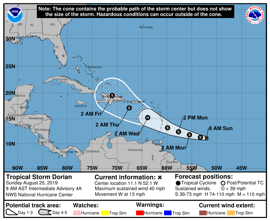
As of this morning’s update from the Miami, Florida – based National Hurricane Center, the center of Tropical Storm Dorian was located near latitude 11.1 North, longitude 52.1 West. Dorian is moving toward the west near 13 mph , and this motion should continue today, followed by a motion toward the west-northwest on Monday and Tuesday. On the forecast track, Dorian is expected to be near the central Lesser Antilles late Monday or early Tuesday.
Maximum sustained winds remain near 40 mph with higher gusts. Some strengthening is forecast during the next 48 hours, and Dorian could be near hurricane strength over the eastern Caribbean Sea. Tropical-storm-force winds extend outward up to 25 miles from the center. The estimated minimum central pressure is 1008 mb or 29.77 inches of mercury.
Heavy rain, gusty winds, and large surf are forecast from Dorian over the next 48 hours. Dorian is expected to produce total rain accumulations of 2 to 4 inches in portions of the Lesser Antilles, with possible isolated maximum amounts of 6 inches. Tropical storm conditions are possible within the watch area by late Monday. Swells generated by Dorian will be affecting portions of the Lesser Antilles by late Monday. These swells could cause life-threatening surf and rip current conditions.
Beyond the Windward and Leeward Islands, the official forecast track from the National Hurricane Center intensifies Dorian to a hurricane by Wednesday morning with impacts to Puerto Rico possible as soon as Wednesday afternoon. The mountains of Puerto Rico and especially Hispaniola will disrupt the flow and structure of the system, perhaps weakening it back down to a tropical storm. Beyond 5 days, it is impossible to say where this system will go or how strong it’ll be when it gets there. Residents of the U.S. East Coast and Gulf Coast, especially Florida, should monitor this storm next weekend. Global forecast guidance, such as the American GFS and European ECMWF, are optimistic about this storm’s future, suggesting it could dissipate over time. Whether such an optimistic computer-generated forecast comes to fruition remains to be seen.
