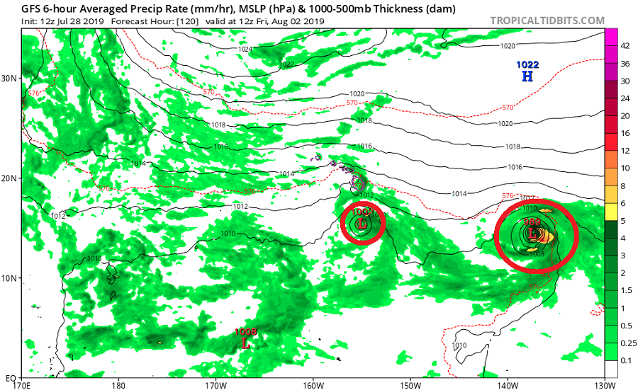
The Eastern and Central Pacific Hurricane Basin appears to be perking up, with two threats arriving to the region that includes Hawaii in the coming days. While global forecast guidance such as the American GFS and European ECMWF computer forecast models paint a picture of double trouble headed for Hawaii, each storm is expected to bring different kinds of threats to the Aloha State.
The closest threat to Hawaii is Tropical Storm Erick. In the latest update from the National Hurricane Center (NHC), the center of Tropical Storm Erick was located near latitude 12.0 North, longitude 131.3 West, which puts it at about 1,665 miles east southeast of Hilo, Hawaii. Erick is moving toward the west near 17 mph and the NHC expects this general motion to continue for the next few days with a slight decrease in forward speed. Maximum sustained winds have increased to near 45 mph with higher gusts. Additional strengthening is forecast by the NHC and Erick is expected to become a hurricane by late Monday or early Tuesday. For now, tropical-storm-force winds extend outward up to 35 miles from the center while the estimated minimum central pressure is 1004 mb or 29.65 inches.
For now, global computer forecast guidance brings Erick south of Hawaii in a weakened state, allowing the center of circulation to pass well south of the entire island chain. However, the system is expected to pass close enough to bring heavy rains to Hawaii, especially east and south facing areas of Hawaii’s Big Island and Maui County. While tropical storm force winds or worse aren’t expected at most locations in Hawaii, strong, potentially damaging wind gusts are possible on the higher terrain of Hawaii’s Big Island, including Mauna Kea, Mauna Loa, and the Saddle Road that is built between the two volcanic slopes. The most likely time for this to occur is at the end of the upcoming week.
A more perilous storm may be right behind it.
As of the latest advisory from the National Hurricane Center, Tropical Depression Seven-E was located near latitude 11.5 North, longitude 109.1 West. The depression is moving toward the west near 21 mph. Unlike Erick, this new system is expected to quickly strengthen to a tropical storm and hurricane in the coming days, growing to more than double the size of Erick. Once named, this system would be called Flossie as it heads off on a generally westward motion with some decrease in forward is expected during the next several days. For now, this depression has maximum sustained winds around 35 mph with higher gusts; the estimated minimum central pressure is 1007 mb or 29.74 inches.’
While global forecast guidance is suggesting Erick will dodge south of Hawaii, the same global guidance is suggesting that Flossie will make a direct hit in Hawaii. Some suggests a landfall could occur on Hawaii’s Big Island while other model output suggests a strike further north up the chain, perhaps on Oahu. Even if the center of circulation doesn’t make landfall, very heavy rain and strong winds would likely impact a large portion of the state, with Hawaii and Maui counties seeing some of the heaviest rain totals. Such heavy rains could trigger life-threatening mud and rock slides. Higher winds, again especially on Hawaii’s Mauna Kea, Mauna Loa, and the Saddle Road between them, are another threat. Impacts from Flossie could occur in as few as 4 days after Erick’s impacts.
Beyond direct impacts, both of these storms are likely to produce indirect impacts on the islands in the form of rough surf, rip currents, and the threat of isolated coastal flooding. These threats will arrive before the storms do and will linger until after they leave.
Officials in Hawaii are urging people there to put their Hurricane Action Plans in order now and stock-up on at least 2-weeks worth of supplies. Because fuel and food need to be imported to the islands, the presence of storms could delay shipments, preventing stores from stocking on basic supplies even if the storms don’t produce a direct hit. As is the case anytime this time of year, plans and supplies should be in order prior to an actual tropical cyclone threat materializing.
It is important to note that this far out, storm track and intensity forecast accuracy are limited and shifts in either are likely. While accuracy of storm track, speed, and intensity will be become better known in the coming days, it is important for people to prepare for the possibility of impact well before an impact occurs.