• Skip to primary navigation
  • Skip to main content
  • Skip to primary sidebar

Weatherboy

Weatherboy Weather News, Maps, RADAR, Satellite, and Forecasts.

  • Local
  • Earth Science News
  • RADAR
  • Current Warnings
  • Satellite
  • Current Maps
  • Forecast Maps
  • Video

Drought Conditions Improving for Much of U.S.

by Weatherboy Team Meteorologist - January 27, 2017

Current U.S. Drought Monitor map shows lingering severe drought, but substantial improvement since the fall. The U.S. Drought Monitor report and map is produced through a partnership between the National Drought Mitigation Center at the University of Nebraska-Lincoln, the United States Department of Agriculture, and the National Oceanic and Atmospheric Administration.

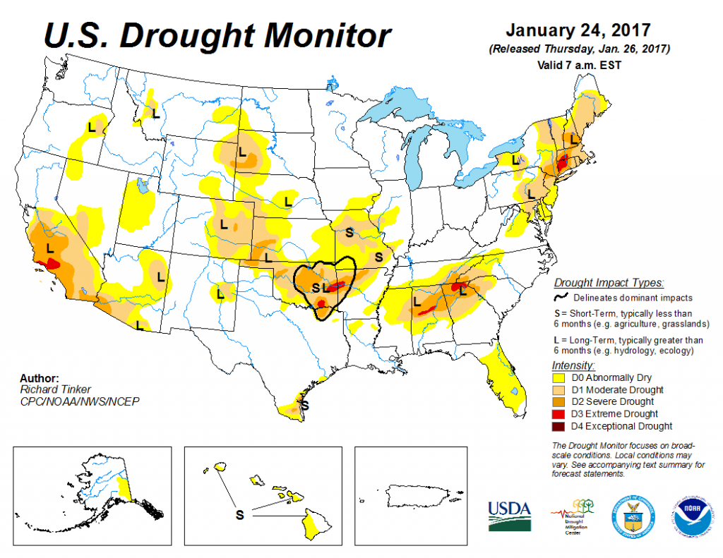
For the most part, drought conditions have improved over much of the United States over the last week, as a series of weather systems have kept the country rather wet or white from coast to coast.  And while significant drought conditions do continue in many parts of the country, this week marks the first time since March 29, 2011 that no part of the United States was under an “Exceptional Drought” designation by the Drought Monitor.

Since the last week, many areas shown in green have improved their drought conditions. A few tiny areas, shown in yellow/orange, have worsened over the last week. Source: US Drought Monitor.

The U.S. Drought Monitor is produced through a partnership between the National Drought Mitigation Center at the University of Nebraska-Lincoln, the United States Department of Agriculture, and the National Oceanic and Atmospheric Administration. Each week they update drought conditions across the entire country. Results are tabulated and mapped each Tuesday and shared the following Thursday.

Like the previous week, January 17-24, 2017 featured moderate to widespread heavy precipitation across many of the nation’s areas of dryness and drought, prompting another round of broad-scale improvements.  There are a few areas that missed recent precipitation, leading to intensification of dryness and drought, but they were few and far between. These drier areas include the leeward parts of Hawaii, the southernmost portions of Texas, patches near the Middle Mississippi Valley, southern Delaware, and portions of central Maryland.


Primary Sidebar

Sponsored Ad

Search

Latest News

  • National Hurricane Center Increases Odds of Cyclone Development Near Florida
  • Severe Weather Outbreak Likely in Mid Atlantic
  • July to Start with Severe Weather Event in New Jersey, Pennsylvania, Delaware, & Maryland
  • Tropical Storm Barry Forms; Additional Storm Possible Near Florida
  • Severe Weather Threat & Tornado Risk Returns to Northeast Today
  • Hurricane Center Monitoring Possible Gulf Disturbance
  • Bolide Explodes over Southeastern United States; Piece Crashes into Home
  • 88 Earthquakes Strike Puerto Rico and Dominican Republic; No East Coast Tsunami Threat
About | Careers | Contact | Contests
Terms | Privacy | Ad Choices
Weatherboy is a (R) Registered Trademark of isarithm LLC, All Rights Reserved.
All content herein is Copyright by Isarithm LLC 1997-2022