While Easter falls on April 1 this year, Mother Nature has her own April Fools Prank to pull on people in the Mid Atlantic with a return visit from Old Man Winter. It’s also becoming more likely, although not definite, that an even more impressive snowfall will follow in the days ahead around April 7/8.
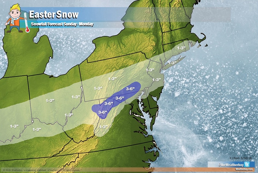
While today feels more like spring than winter, the opposite will be true come Sunday night. An area of high pressure will slip off the coast on Saturday, allowing a cold front to move through the region late Saturday night into early Sunday morning. A wave of low pressure will develop later Sunday into Monday, with a shield of precipitation building over portions of the Mid Atlantic. While plain rain will fall in southern New Jersey, much of Delaware, southeastern Maryland, and most of Virginia, there should be enough cold air to produce accumulating snow from southern Indiana to Rhode Island Sunday night. With the sun down, light accumulations are expected, generally 1-3″, across portions of Indiana, Ohio, Kentucky, West Virginia, Pennsylvania, Virginia, Delaware, New Jersey, New York, Connecticut, and Rhode Island. With the right timing of heavier precipitation falling with the coldest air available in the middle of the night, there will be a band of heavier snow accumulations across the higher terrain of West Virginia, northwestern Virginia, central Maryland, and southeastern Pennsvylania; here; 3-4″ of heavy wet snow is possible. While 1-3″ of snow will fall in places like Philadelphia, PA, New York City, NY, and Providence, RI, snow will struggle to stick in these urban heat islands even at night; as such, a slushy inch or two are expected in those urban areas. Outside of the urban areas, though, 2-3″ should accumulate, especially on grassy surfaces. Because this is a fast-moving weak system, damaging wind and severe coastal flooding threats should not be a problem.
Surface high pressure will return later Monday, steered by a fairly quick zonal mid-level flow. This will allow things to dry out and most frozen precipitation to quickly melt away. By Tuesday, even the pockets where heavier snow is expected to fall should be snow-free.
Meteorologists remain concerned about the potential for a more significant winter storm around April 7 or 8. While it’s too early to get into specifics and nail down a forecast solution, odds are increasing of a significant snowfall for portions of Pennsylvania and New Jersey then.
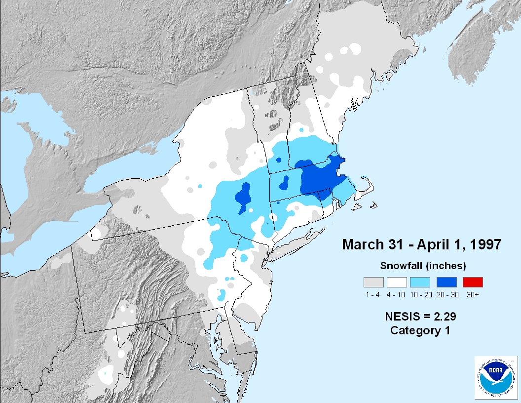
While not very common, snow does fall in parts of the Northeast and Mid Atlantic in early April. In 1997, the “April Fools Blizzard” brought heavy snow to portions of the northeast between March 31 and April 1.
