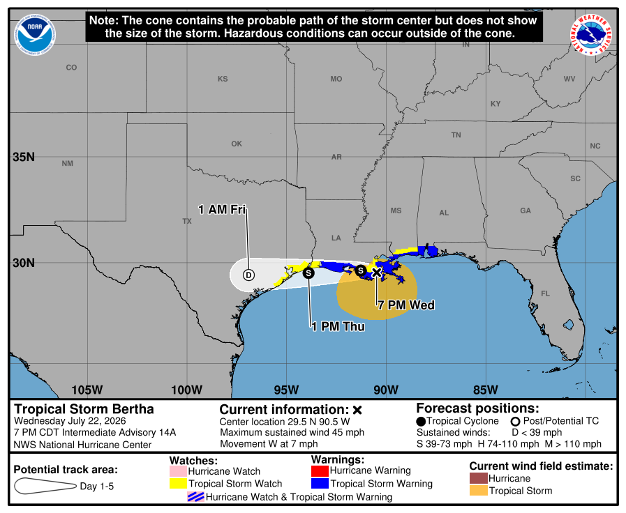
Tropical Storm Bertha made landfall on the Louisiana coastline today and is now forecast by the National Hurricane Center (NHC) to move west and eventually break-up over Texas later tomorrow into Friday.
Bertha’s center made landfall on the eastern side of St. Bernard Parish, Louisiana, around 2 pm today. According to the NHC, the main part of the circulation remains devoid of deep convection, although there is a large and persistent convective complex ongoing south of the Louisiana coast. Based on flight-level data from an earlier Air Force Reserve Hurricane Hunter flight, it appears the worst of the storm is well to the south and southeast of the center over the open Gulf of America waters.
As of the latest advisory from the NHC, Bertha was located near 29.5N 90.5W which is about 40 miles southwest of New Orleans, Louisana and about 165 miles east-southeast of Lake Charles, Louisiana. With maximum sustained winds of 45 mph and minimum central pressure about 1002 mb or 29.59″, the storm is moving west at 7 mph.
With the storm headed west, a Tropical Storm Warning is in effect for the area from the Alabama/Florida border to Cameron, Louisiana, for the Metropolitan New Orleans area, and for all of Lake Pontchartrain. A Tropical Storm Watch is in effect for the area west of Cameron, Louisiana, to Sargent, Texas; Lake Maurepas is also under a Tropical Storm Watch. A Tropical Storm Warning means that tropical storm conditions are expected somewhere within the warning area, in this case within 24 hours. A Tropical Storm Watch means that tropical storm conditions are possible within the watch area, in this case within the next 24 to 36 hours.
The NHC says that Bertha is expected to track westward, moving very near the southwestern coast of Louisiana to the upper Texas coast by Thursday afternoon.
According to the NHC, model fields suggest that the prominent band of tropical-storm-force winds to the east and south of the center will persist through Thursday, and therefore only minimal weakening is expected over the next 24 hours. The NHC forecast maintains Bertha as a tropical storm for about the next 24 hours until the center reaches the upper Texas coast. Global model fields suggest the surface circulation will disintegrate shortly after the center moves onshore the Texas coast.
“A remnant low forecast position is provided inland over Texas at 36 hours, but it’s possible the system will have dissipated by then,” says the NHC.
With much of the wind and rain from the system over open Gulf waters, there should be very little impacts to Texas, especially near the Galveston / Houston metro area. Further down the coast near Victoria, the remnant moisture is expected to rain itself out, but again, the worst of the storm will be over water moreso than land.
