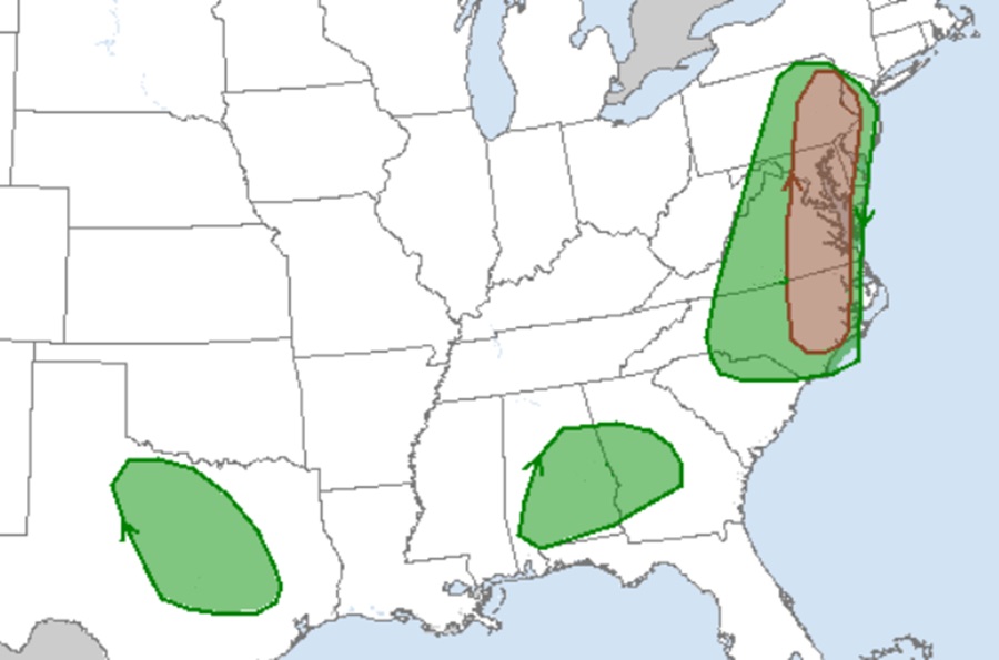
This Memorial Day, portions of the Mid Atlantic are expected to see an outbreak of severe storms; according to the National Weather Service’s Storm Prediction Center (SPC), there is even an elevated threat of tornadic thunderstorms stretching from portions of New Jersey and Pennsylvania south through Delaware, Maryland, Virginia, and North Carolina. Even beyond the highest risk area for tornadoes, severe thunderstorms are possible from the Mid Atlantic to the Southeast Monday into Monday night, with severe wind, hail and potentially a tornado or two expected there as well.
There are several meteorological ingredients coming together to create an outbreak of severe weather in time for Memorial Day. A strong surface low will exist near Lower Michigan Monday morning; this low will deepen through the day as it moves northeast of Lake Superior by the evening. A cold front will extend from this surface low across western Lake Erie to the Mid-Mississippi Valley in the morning and cross the Appalachians by the early evening hours. Strong to severe thunderstorms are possible along and ahead of this cold front during the afternoon into the evening hours.
The SOC says that effective shear will support both multicell and supercell clusters. Thermodynamically, the best environment should be across Virginia and North Carolina. However, stronger flow across eastern Pennsylvania may be more supportive of supercells and thus a greater hail threat despite the weaker thermodynamics. In addition, some forecast soundings show low-level shear supportive of a tornado or two across most of the warm sector from North Carolina into eastern Pennsylvania and the Delmarva, including western portions of New Jersey.
In addition to the severe weather threat, the National Weather Service is also warning of a flash flood threat for northeastern and eastern Pennsylvania, southeastern Upstate New York, and northern New Jersey. In this area, hourly rain totals to 2.5″ and local amounts to 5″ are considered possible where cells merge, train, or where mesocyclones form.
