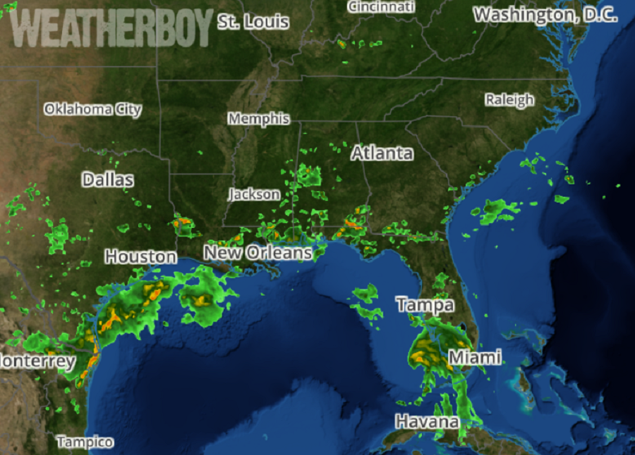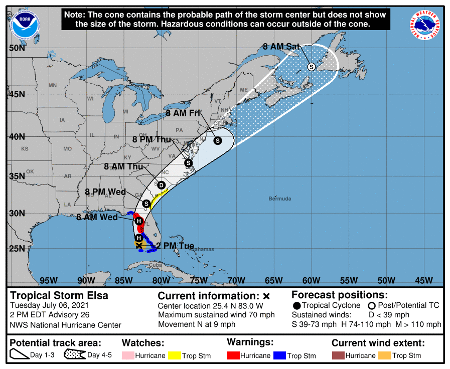
Tropical Storm Elsa is approaching the Florida Gulf coast and is gaining strength, prompting the National Hurricane Center to issue Hurricane Warnings for portions of Florida. As of 2pm ET, the storm was about 95 miles northwest of Key West and 180 miles south of Tampa; with maximum sustained winds of 70 mph, it is just a few miles per hour short of becoming a hurricane again.
With Elsa likely to become a hurricane before making landfall on the Florida coastline, the National Hurricane Center (NHC) has issued a Hurricane Warning along the west coast of Florida from Egmont Key to the Steinhatchee River. In addition to the Hurricane Warning, a Storm Surge Warning is in effect for the west coast of Florida from Bonita Beach to the Aucilla River, including Tampa Bay. A Tropical Storm Warning remains in effect from Craig Key to the Dry Tortugas, the west coast of Florida from Flamingo to south of Egmont Key, and for the west coast of Florida north of the Steinhatchee River to the Ochlockonee River.

A Storm Surge Warning means there is a danger of life-threatening inundation, from rising water moving inland from the coastline, in the indicated locations. The National Hurricane Center warns: “This is a life-threatening situation. Persons located within these areas should take all necessary actions to protect life and property from rising water and the potential for other dangerous conditions. Promptly follow evacuation and other instructions from local officials.”
A Hurricane Warning means that hurricane conditions are expected somewhere within the warning area, in this case within the next 24 hours. Preparations to protect life and property should be rushed to completion.
A Tropical Storm Warning means that tropical storm conditions are expected somewhere within the warning area.
In addition to these warnings, a Tropical Storm Watch is now in effect on the East Coast from the mouth of the St. Marys River to the South Santee River in South Carolina. A Tropical Storm Watch means that tropical storm conditions are possible within the watch area.
Additional watches and warnings may be needed for the U.S. East Coast today or tomorrow as Elsa moves up the coast.
For now, Elsa is moving toward the north near 9 mph and a generally northward motion is expected today and tonight. A turn toward the north-northeast is expected on Wednesday, followed by a faster northeastward motion by late Thursday. On the forecast track, Elsa will move near or over portions of the west coast of Florida later today through tonight. Elsa is forecast to make landfall along the north Florida Gulf coast on Wednesday and then move across the southeastern United States through Thursday.
While Elsa is forecast to become a hurricane before making landfall, weakening is forecast to begin after Elsa moves inland by late Wednesday. By late Thursday, the NHC expects Elsa to re-intensify back into a tropical storm as it moves through portions of Virginia, Delaware, Maryland, and New Jersey. By Friday morning, the storm should be off the Jersey shore southeast of New York City. By Saturday morning, it should race to Newfoundland, Canada.

For now, a variety of hazards will impact Florida.
Hurricane wind force conditions are expected within the Hurricane Warning area on the Florida Gulf coast beginning this evening. Tropical storm conditions will continue over portions of the warning area in the Florida Keys through this evening. Tropical storm conditions are expected to spread northward into west-central Florida and the Florida Big Bend region in the Tropical Storm Warning area tonight and early Wednesday. Tropical storm conditions are possible in the watch area in Georgia and South Carolina Wednesday night and early Thursday.
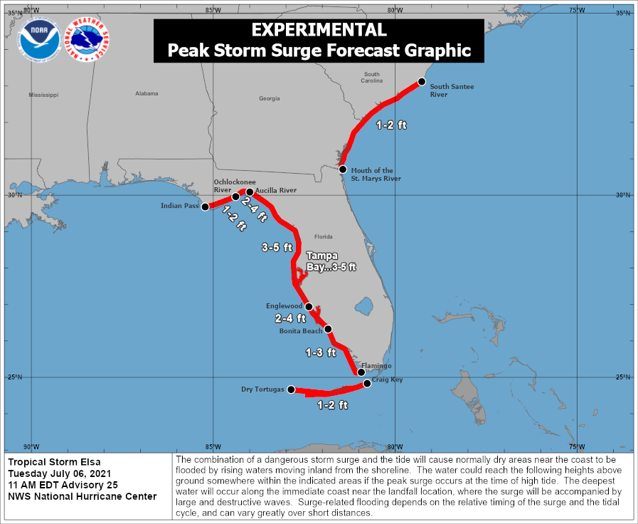
The combination of a storm surge and the tide will cause normally dry areas near the coast to be flooded by rising
waters moving inland from the shoreline. The water could reach as high as 3-5 feet if the peak surge occurs at the time of high tide. The greatest surge is expected to occur between Englewood, Florida to Aucilla River including Tampa Bay, while a moderate surge is also expected from Bonita Beach, Florida to Englewood, Florida including Charlotte Harbor. Surge-related flooding depends on the relative timing of the surge and the tidal cycle, and can vary greatly over short distances.
Heavy, flooding rains are also expected from Elsa. Across the Florida Keys into southwest and western portions of the
Florida Peninsula, 3-5″ with localized maximum totals up to 8″ is possible through Wednesday. Such rains may result in considerable flash and urban flooding, along with minor to isolated moderate river flooding. Across the rest of Florida 2-4″ totals with isolated amounts to 6″ are possible through Wednesday night which could cause additional flooding too. Across portions of southeast Georgia and the Lowcountry of South Carolina, 3-5″ with isolated areas of up to 8″ are possible. Across coastal portions of North Carolina into southeastern Virginia, 1-3″ with isolated totals up to 5″ are possible Wednesday night through Thursday night, which could lead to isolated flash and urban flooding there too.
A few tornadoes are possible today through tonight across the Florida Peninsula. The tornado threat will continue on Wednesday across north Florida, southeast Georgia, and the Lowcountry of South Carolina. The tornado threat should shift to the eastern Carolinas and far southeast Virginia on Thursday.
Rough surf and large swells will spread northward across portions of the Florida Keys and the west coast of Florida through early Wednesday. These swells are likely to cause life-threatening surf and rip current conditions.