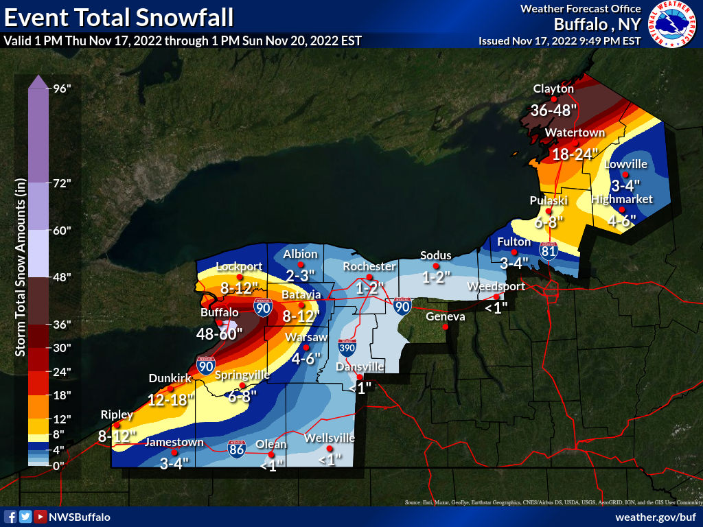
An epic lake-effect snowstorm is beginning to unfold in portions of Upstate New York, where a crippling 3-5 feet or more of snow is expected to fall. The greatest risk of the highest totals will be from South Buffalo to Lancaster. The heaviest snow is expected tonight through Friday night when snowfall rates could exceed 3 inches per hour. Winds gusting as high as 35 mph will produce patchy blowing snow, making it very difficult to see outside. With visibility near zero at times, it will become dangerous to drive or even walk outside.
Thundersnow storms are also likely; lightning can kill in any weather, including winter weather; the National Weather Service cautions, “when thunder roars, head indoors; if thunder is close enough to be heard, lightning is close enough to kill.”
Lake Effect Snow Warnings, Lake Effect Snow Emergency, and Winter Weather Advisories are up for the areas expecting the snow.
The heaviest snow will be in the areas most favorable for lake effect development down-wind from Lake Ontario and down-wind from Lake Erie.
An area of heavy lake effect snow will continue to move northeast across much of the Niagara Frontier this evening, including all of the Buffalo Metro area. This initial wide area of moderate to heavy snow will drop a quick few inches across much of the area. Following this first burst of snow, a more narrow, focused band of heavy lake effect snow will develop in the Buffalo Metro area late tonight.
The areas expected to be hit hardest include Buffalo, Cheektowaga, Niagara Falls, West Seneca, North Tonawanda, Clarence, Lockport, Lackawanna, Batavia, Kenmore, Depew, Amherst, Tonawanda, Lancaster, Hamburg, East Aurora, Medina, Albion, Williamsville and Darien Lakes State Park. This includes Interstate 90 between exits 48 and 57A, where travel may become dangerous if not outright impossible at times.
The National Weather Service issued caution with their latest Special Weather Statement: ” Conditions can deteriorate rapidly in winter weather situations. Be prepared for snow or ice covered roads. Slow down and allow extra time to reach your destination.”
This winter storm should wrap up by late Sunday or early Monday.
