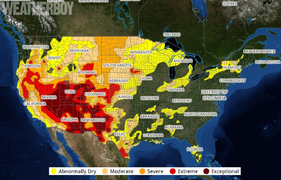
According to the final Drought Monitor report for February, the United States is even more dry than before, with conditions classified as “extreme drought” expanding in portions of the U.S. west. Unfortunately, it doesn’t look like conditions in this first week of the new month will help much.
The U.S. Drought Monitor is produced through a partnership between the National Drought Mitigation Center at the University of Nebraska-Lincoln, the United States Department of Agriculture, and the National Oceanic and Atmospheric Administration.
January and February had several notable heavy precipitation events in the U.S.. An atmospheric river event, a parade of winter storms in the northeast, and a bitter cold Arctic air mass accompanied with snow and ice all the way to the southern Gulf Coast all played a role in precipitation events across the country.
A major atmospheric river event unfolded at the end of January, dumping 5-10+ feet of snow at higher elevations of the west coast while coastal areas saw rainfall measured in feet too. While this helped kick-off January with significant snowpack, the heavy rains didn’t make their way to portions of bone-dry Nevada, Utah, Arizona, Colorado, and New Mexico where drought conditions are considered “extreme” or “exceptional.” And unfortunately for those areas desperate for rain and snow, additional atmospheric river events didn’t come in later in February
While the southwest was desperate for precipitation, portions of the northeast were over-run by a parade of storms that brought significant snow and soaking rains to portions of New England and the Mid Atlantic. During the second week of February, 3 storms struck over a 7 day period, adding to the snowpack to the north while drenching places south of a rain/snow line that set-up with each storm in the central or southern Mid Atlantic. Fortunately, this precipitation stamped-out the threat of drought in much of New England and the Mid Atlantic, except for portions of northern Upstate New York and Vermont that missed-out on precipitation from coastal storm systems.
St. Valentine’s Day 2021 was a frigid one, with much of the midwest in a deep freeze; that deep freeze got deeper into the south, bringing sub-freezing temperatures to the Texas and Louisiana Gulf Coast. Daily temperature anomalies were 30 to 40 degrees F below normal and readings dropped below -40 degrees F in Minnesota and 0 degrees F as far south as central Texas. While conditions were frigid, snow and ice made their way across the Lone Star State into the interior southeast, coating places that don’t see much frozen precipitation with a layer of snow and freezing rain. While drought conditions aren’t nearly as bad as they are in the western states, there are pockets of very dry areas: south Texas, northwestern Kansas, southeastern Nebraska, and northwestern Iowa.
March has kicked-off with more of the same dry weather in the west. Little to no precipitation is forecast for the Southwest, California, the northern and central Plains, and upper Midwest in the short-term. Temperatures will average below normal in the West, Rockies, and northern Plains, and above normal in the eastern half of the Nation.
