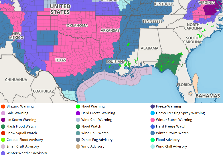
A severe winter storm will dive to the Gulf Coast, bringing significant snow and ice to Texas and Louisiana. Ahead of the storm system, the National Weather Service has issued Winter Storm Warnings and Watches for Texas, Louisiana, Mississippi, Arkansas, and Oklahoma. For some in Texas, this is the first time they’ve been under a Winter Storm Watch or Warning for more than 10 years.
In Texas, Governor Greg Abbott wants people to take the storm threat seriously. He has already declared a statewide disaster declaration for every single county in the state. Officials are also urging people to reduce electricity consumption; surge in demand from extremely cold weather combined with likely damage from significant ice and snow will severely impact the electrical grid there.
Icy highway = recipe for disaster.#TXwx https://t.co/aUGph72WSS
— the Weatherboy (@theWeatherboy) February 11, 2021
Governor Abbott urged Texans to “heed the guidance of their local leaders and stay alert to changing weather conditions in their area.” In a press conference yesterday afternoon, Abbott said, “Everybody in this state should have several collective goals over the next few days, one of which should be that we will not replicate what happened in Fort Worth,” referring to Thursday’s deadly 133-vehicle pileup on an iced-over interstate responsible for sixth deaths. “This will be probably more snow over a larger swath of land to a higher degree than ever before in Texas history,” he added.
An Arctic high pressure system supplying sub-freezing temperatures is working in tandem with an active storm track to generate a large swath of accumulating snowfall and treacherous ice accumulations. While conditions temporarily improve in the Mid-Atlantic, conditions will deteriorate throughout the day in the southern Plains and Lower Mississippi Valley as an upper-level trough in the Southwest spawns a major winter storm over the South Central U.S.
Periods of snow, falling heavily at times, will be common from New Mexico to the Mississippi Valley today with the heaviest accumulations likely to occur in central Oklahoma and the Sacramento Mountains of New Mexico. In addition to the snow, significant ice accumulations are forecast from the Texas coast to the Tennessee Valley from Sunday afternoon into Monday.
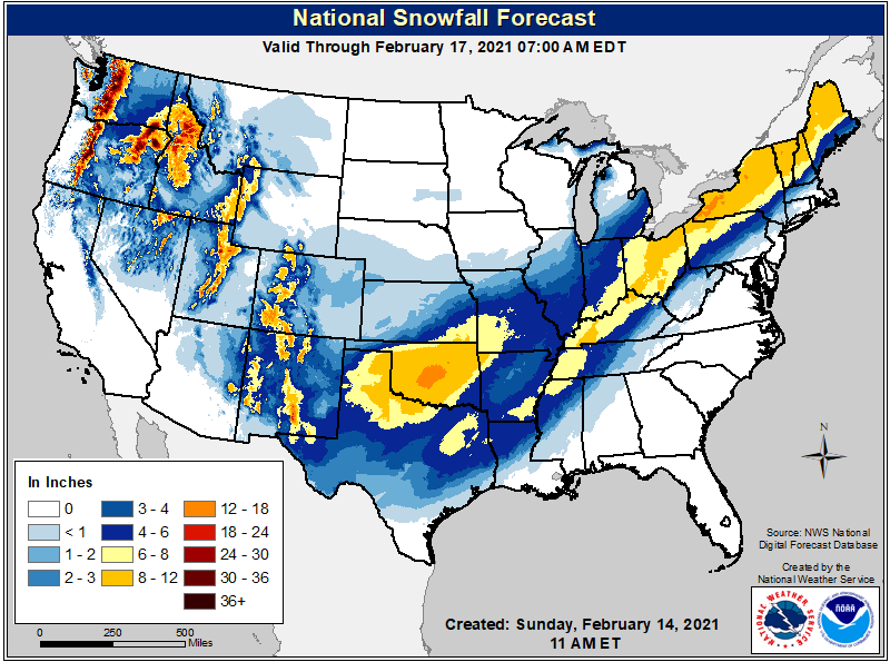
The worst ice-related impacts occur on Monday as a low pressure system gathers strength in the Gulf of Mexico. The swath of accumulating ice on Monday will eventually stretch from south Texas north and east to the northern Mid-Atlantic. Heavy snow on Monday will also blanket much of the Central Mississippi River Valley, the Ohio Valley, and into interior portions of the Northeast. The forecast through early Tuesday morning calls for 8-12″ in central Oklahoma with locally higher amounts possible. An area of 4-8″ of snow will extend from east Texas and the Ohio Valley to the Northeast.
Substantial ice accumulations of up to a half inch are possible from the Lower Mississippi Valley to the Tennessee Valley leading to dangerous travel conditions, numerous power outages, and extensive tree damage. For some, this will be the worst ice storm in more than a decade too.
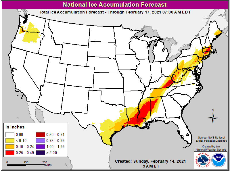
On Tuesday morning, the primary low pressure system responsible for this winter storm will be located near or over New Jersey. This position will allow for snow to fall, heavy at times, across interior New England. However, because the system is moving over land rather than water, it will be introducing more milder air into it. This means most precipitation near and south and east of I-95 will fall as plain rain. North of it, into central upstate New York, southern Vermont, southern New Hampshire, Massachusetts, and parts of southern Maine, significant freezing rain and sleet is expected. Louisiana, Mississippi, Kentucky, Connecticut, and Massachusetts may end up with the most ice from this major winter storm.
Another impressive winter storm is likely to form and impact portions of the Mid Atlantic and Northeast once again later in the week. The extremely active weather pattern is expected to produce another potent area of low pressure in the eastern U.S. and slide it up into the northeast Thursday and Friday.
