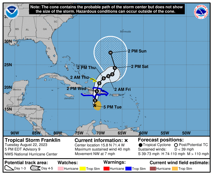
Eyes are returning to focus on Tropical Storm Franklin in the Caribbean after Tropical Storm Harold slammed into Texas early today. Franklin is forecast to intensify in the Atlantic Hurricane Basin while the remnants of Harold continue to soak portions of Texas and the midwest.
At 1 am this morning local time, the National Hurricane Center upgraded Tropical Depression #9 into Tropical Storm Harold hours before it made landfall over south Texas. While the system lacks a significant wind field of severe winds, the tropical storm has plenty of moisture to work with. The system is expected to produce rainfall amounts of 3-5″ today with isolated higher amounts to 7″ across south Texas today into tomorrow. Scattered instances of flash flooding will be possible. Across nearby Mexico, rainfall amounts of 4-6″ with local amounts of 10″ are expected across portions of northern Coahuila and northern Nuevo Leon today and Wednesday. Scattered instances of flash flooding are expected.
Since landfall, the system continues to weaken and Franklin is now just a Tropical Depression. Despite the depression status, heavy rains will continue to fall.
Turn around, don’t drown! NEVER drive through flood waters! https://t.co/aBWVNtoHRG
— the Weatherboy (@theWeatherboy) August 22, 2023
Elsewhere in the tropics, Franklin is poised to bring flooding rains to Hispaniola. According to the National Hurricane Center’s latest update, Tropical Storm Franklin has maximum sustained winds of only 40 mph for now, but with time, it is expected to evolve into a hurricane. Located about 210 miles south-southwest of Santo Domingo, Dominican Republic, Franklin is moving to the northwest at 7 mph.
With Tropical Storm Franklin nearing the coast, a Tropical Storm Warning is in effect for the Dominican Republic’s entire south coast from Haiti border eastward to Cabo Engano, and the entire north coast from Haiti border eastward to Cabo Engano. A Tropical Storm Warning is also up for the entire south coast of Haiti from Anse d’Hainault eastward to the Dominican Republic border. A Tropical Storm Watch is in effect for the Turks and Caicos Islands. A Tropical Storm Warning means that tropical storm conditions are expected somewhere within the warning area within 36 hours. A Tropical Storm Watch means that tropical storm conditions are possible within the watch area, generally within 48 hours.
The National Hurricane Center says Franklin should make a turn toward the north tonight, followed by a turn toward the northeast by Thursday. On the forecast track, the center of Franklin is expected to approach the southern coast of Hispaniola tonight, cross the island on Wednesday, and then emerge over the southwestern Atlantic waters late Wednesday. While little change in strength is forecast during the next couple of days while Franklin moves near and across Hispaniola, some strengthening is possible late Thursday into Friday as Franklin moves farther northeast over the southwestern Atlantic waters. The official National Hurricane Center forecast brings Franklin up to hurricane strength by the weekend. It is still too soon to know if the U.S. East Coast or the island of Bermuda will be at risk from this storm next week.