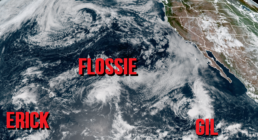
The Central Pacific Hurricane Center in Honolulu, Hawaii and the National Hurricane Center in Miami, Florida are tracking three disturbances in the Pacific: Eric, Flossie, and Gil. None are expected to bring direct impacts to Hawaii in the coming days.
In the latest update from the Central Pacific Hurricane Center, the center of Tropical Storm Erick was located near latitude 17.3 North, longitude 163.9 West. Erick is currently moving westward near 13 mph. According to the Central Pacific Hurricane Center, this motion will become west-northwestward later today then continue in that direction through Sunday and early Monday. Maximum sustained winds are near 40 mph with higher gusts while the estimated minimum central pressure is 1005mb or 29.68 inches. Erick is expected to weaken to a tropical depression later today or tonight, then become a post-tropical cyclone on Sunday.
On this track, Erick will remain away from Hawaii. Yesterday, it passed well south and southwest of Hawaii’s Big Island. While the core of strong winds never made it to Hawaii, some outer bands of heavy rain did. There were reports of flooding and rockslides on Hawaii Island, with rainfall amounts generally topping-out in the 3-6″ range.
Erick and an approaching area of low pressure will help protect Hawaii from the next storm nearing the area: Flossie.
Now, Flossie is located roughly 695 miles east of Hilo, Hawaii. Maximum sustained winds are near 50 mph with higher gusts. The Central Pacific Hurricane Center is forecasting the system to weaken during the next 48 hours, becoming a tropical depression by sometime tomorrow as it continues to dissolve. Today, tropical-storm-force winds extend outward up to 105 miles from the center while the estimated minimum central pressure is 1003 mb (29.62 inches).
As Erick and an approaching area of low pressure swings in from the west, it will help lift Flossie and its remnants to the north of Hawaii. As such, tropical storm force conditions or worse are not expected at all anywhere in Hawaii. With the system forecasted to weaken and its overall associated area of moisture becomes entangled with Erick’s remnants and the trough of low pressure to the north, not much rain is expected in Hawaii either. While some moisture will make its way to Hawaii as Flossie moves north and west well away from Hawaii, rain should be consistent with moisture-rich trades moreso than a tropical cyclone. It is likely Flossie’s outer fringes will dump even less rain on Hawaii than Erick did.
While rain and wind aren’t an issue for Erick or Flossie in Hawaii, rough surf is. Lingering swells from Erick and new swells generated by Flossie will continue to affect portions of the main Hawaiian Islands over the next couple of days, potentially producing dangerous surf conditions, mainly along east and southeast facing shores.
While Erick fades away and Flossie fizzles, it looks like a new tropical system will dissolve before it has a chance to become much. The National Hurricane Center began issuing advisories for Tropical Storm Gil today. In their latest update, Gil was located near latitude 15.0 North, longitude 122.4 West. Gil is moving toward the west-northwest near 12 mph . A general westward motion at about the same forward speed is forecast for the next couple of days. Now, maximum sustained winds in Gil’s tiny core are estimated to be around 40 mph. The National Hurricane Center expects Gil to enter an area hostile for development in the coming days; as such, they officially forecast the system to completely dissipate by Tuesday over the open waters of the Pacific, far from Hawaii and far from Mexico.
Elsewhere in the Pacific and the Atlantic, no tropical cyclone formation is expected over the next 5 days.