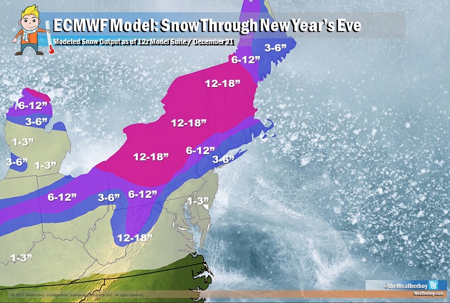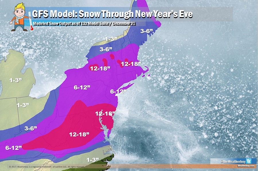
The global forecast model giants, the American GFS and the European ECMWF, are struggling to come to a solution with how winter storms will evolve in the northeast US; they continue to disagree with the remaining weather through the end of the year.Not only do the models disagree with each other, but there has been significant run-to-run disagreement with the models themselves, especially with the American GFS model which has flip-flopped on possible solutions every 6, 12, and 24 hours. A complex weather pattern will establish itself over the United States beyond this weekend, with a large pool of cold air arriving over the central United States from Canada, and a busy jet stream with a few storm formation chances between this weekend and New Year’s Eve. Each model believes the cold air will settle-in differently while each model also believes the storm track tied to the jet stream will be significantly different too. With such different outputs, snowfall forecasts suggested by each model are very different from each other.

The European model sets up the axis of heaviest snow over the next 10 days from the Great Lakes region to New England while the American model sets up the axis much further south over portions of the Mid Atlantic, sparing New England of the most widespread, heavy snow. The American GFS suggests the snow will accumulate from three storms: the first on Christmas Eve over New England, the second is lighter snow further south on Christmas Day, the third and most significant is on the 29th and 30th, which brings most of the snow to the Mid Atlantic area. In contrast, the European ECWMF suggests a different scenario although it calls for 3 systems too. The first is a rather warm one, bringing rain up and beyond the I-95 corridor on Saturday while snow falls over New England. A second storm brings snow a bit further south, including the I-95 corridor on the 29th, with the third and final system bringing heavy snow to New England on New Year’s Eve, with an icy mix further south into the New York City metro area and elsewhere along the I-95 corridor.
With conflicting data between and within the model runs, confidence is very low with how the weather pattern will evolve beyond Christmas Eve. One thing is certain though: it should remain stormy through to the end of the year. Whether precipitation falls as snow, rain, or some icy mix, travel will likely be impacted for many days on the roads and in the sky before 2018 arrives. For the latest Weatherboy forecasts for specific towns/cities or zip codes, visit the Weatherboy local weather page here.