Tropical Storm Franklin has crossed over the Dominican Republic; as it moves north, the National Hurricane Center expects it to grow into a hurricane with time. The East Coast is keeping a close eye on things in the hurricane basin; with the possibility of a disturbance developing in the Gulf of Mexico and a growing hurricane Franklin in the Atlantic, the East Coast may see tropical cyclone threats in the coming days.
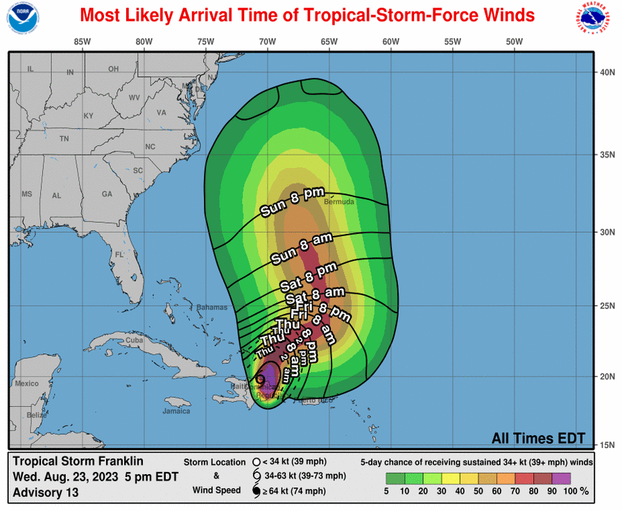
According to the National Hurricane Center, while the center of Franklin is north of the Dominican Republic, the threat of heavy rain and flash flooding continues there. The last NHC update centers Tropical Storm Franklin about 75 miles south-southeast of Grand Turk Island; the storm has maximum sustained winds of 40 mph and a minimum central pressure of 1004 mb or 29.65″.
Franklin’s future path is in question. Currently, the tropical storm is moving toward the north-northeast near 13 mph. The NHC says that a turn to the northeast and then east-northeast with a decrease in forward speed is forecast on Thursday and Friday. On the forecast track, the center of Franklin will continue to move farther away from Dominican Republic and then move over the southwestern Atlantic into the weekend.
As it moves away from the Dominican Republic, the NHC says Franklin will grow. Gradual strengthening is forecast during the next several
days, and Franklin could be near hurricane strength over the southwestern Atlantic by Saturday.
Meanwhile, the National Hurricane Center is also monitoring other disturbances in the Atlantic Hurricane Basin.
One area of concern closest to the United States is over the Northwestern Caribbean Sea today. According to the NHC, an area of low pressure could form in a couple of days over the northwestern Caribbean Sea. Some slow development of this system is possible over the weekend and early next week while it moves slowly northward across the eastern Gulf of Mexico. The NHC officially says there’s only a 20% chance of tropical cyclone formation here, but many other global computer forecast models are more bullish and have a strong tropical cyclone by the weekend.
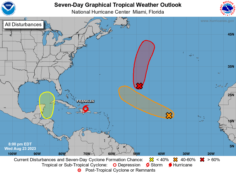
Whether this system develops or not could influence Franklin’s path. Franklin could also influence this disturbance’s future path, putting a lot of uncertainty into the east coast forecast beyond this weekend. As such, residents anywhere along the U.S. East and Gulf Coasts should closely monitor the tropics this weekend and make sure they have a Hurricane Action Plan in place; it’s possible it may need to be acted upon as early as the end of the weekend.
Elsewhere, the NHC also is tracking two other systems. The first is in the Central Subtropical Atlantic and is made up with the remnants of what was once Tropical Storm Emily. Located about 1000 miles east-southeast of Bermuda, these remnants continue to produce a large area of disorganized showers and thunderstorms. The NHC said today in the latest Tropical Outlook, “Upper-level winds are forecast to become more conducive for development by tomorrow, and this system is likely to regenerate into a tropical storm by Friday while the system moves northward over the subtropical central Atlantic.”
The other system the NHC is tracking is in the eastern Atlantic. Disorganized showers and thunderstorms continue in association with an area of low pressure located several hundred miles west of the Cabo Verde Islands. The NHC says this system’s circulation has become better defined since yesterday, despite marginal environmental conditions, and further slow development is possible. The low has the potential to become a tropical depression by the weekend while the system moves west-northwestward to northwestward into the central tropical Atlantic.
