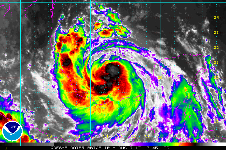
Tropical Storm Franklin is gaining strength and is forecast to become a hurricane today before striking Mexico on Thursday evening. According to the National Hurricane Center (NHC), numerous assets have been deployed to the Bay of Campeche to explore the hurricane, including Air Force Reserve Hurricane Hunter aircraft and a Global Hawk drone. Reports from those air assets show a storm gaining strength while satellite imagery has shown increased organization, with a well-defined convective band with strong winds.
The initial motion is now a little faster than before. A mid- to upper-level ridge to the north and northwest of Franklin should keep the cyclone moving generally westward for the next 24 hours or so, followed by a south of west motion as Franklin’s circulation interacts with the mountainous terrain of Mexico. The new official forecast track from the NHC, which is nudged a little north of the previous track, has the center making landfall in the Mexican state of Veracruz just past the 24 hour point, followed by a motion into the mountains of eastern Mexico.
Franklin is crossing the very warm waters of the Bay of Campeche and continued strengthening appears likely. The SHIPS Rapid Intensification Index shows a 40-50% chance of 25 kt of strengthening during the next 24 hours. However, the large-scale models forecast moderate northeasterly shear to develop during that time, which may slow intensification below rapid levels. The new intensity forecast from the NHC calls for Franklin to become a hurricane Wednesday afternoon and reach a peak intensity of a Category 1 hurricane near the time of landfall.
After landfall, rapid weakening is forecast as Franklin moves into the mountains of eastern Mexico, and the low-level center is likely to dissipate completely by 48 h. It should be noted that some large-scale models re-form the low-level center over the Pacific as the remnants of Franklin reach that basin in about 3 days.
Franklin is expected to increase in size over the next 24 hours, which has required a northward extension of the Tropical Storm Warning on the eastern coast of Mexico. The Government of Mexico has also extended the Hurricane Warning for the coast of Mexico northward to Cabo Rojo.
Right now, a Hurricane Warning is in effect for the coast of Mexico from Puerto de Veracruz to Cabo Rojo while a Hurricane Watch is in effect for the coast of Mexico north of Cabo Rojo to Rio Panuco. A Tropical Storm Warning is in effect for the coast of Mexico east of Puerto de Veracruz to Ciudad del Carmen and the coast of Mexico north of Tuxpan to Barra del Tordo. A Hurricane Warning means that hurricane conditions are expected somewhere within the warning area, in this case within 24 hours. Preparations to protect life and property should be rushed to completion. A Hurricane Watch means that hurricane conditions are possible within the watch area. A Tropical Storm Warning means that tropical storm conditions are expected somewhere within the warning area.
Experts believe this Atlantic Hurricane Season, which runs through to the end of November, will be a busy one. Dr. Phil Klotzbach and the experts at Colorado State University updated their seasonal outlook again on July 5, showing a much more active than normal season expected. The National Oceanic and Atmospheric Administration (NOAA) also released their own forecast which shows this hurricane season to be likely more active than others.
