While Tropical Storm Franklin made its first landfall over the Yucatan Peninsula last night, eyes are on its second landfall on the Mexican landfall …and the potential development of yet another tropical disturbance in the Atlantic.
Franklin formed over the western Caribbean Sea on Sunday and made its first landfall near Pulticub, Mexico, at approximately 11:45pm on Monday. Franklin had maximum-sustained winds of 60 mph as it came onshore along the east coast of Mexico’s Yucatan Peninsula Monday night. Franklin is forecast to exit the Yucatan later today and pick up strength as it moves back over open waters. While the official forecast from the National Hurricane Center (NHC) calls for Franklin to remain as a Tropical Storm prior to its second landfall, some forecast guidance suggests that it may strengthen to a minimal hurricane before hitting Mexico again.
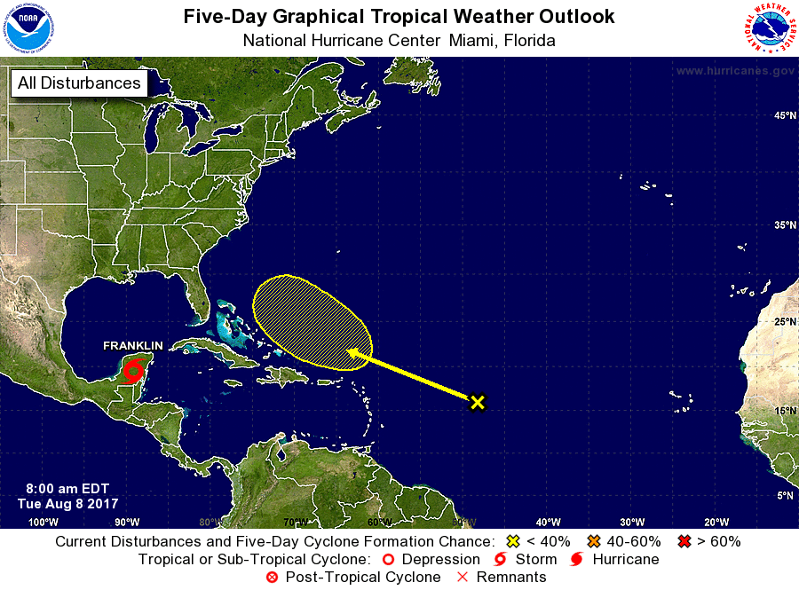
While Franklin moves into the southern Gulf of Mexico, eyes are also on a disturbance that’s tracked across the Atlantic over the last several days. A trough of low pressure located about 800 miles east of the Lesser Antilles continues to produce an area of disorganized showers and thunderstorms. Development of this system is not expected during the next few days due to unfavorable environmental conditions. However, some development of this system is possible this weekend while the system moves generally west-northwestward at about 15 mph over the western Atlantic. Some forecast guidance has suggested that it may have time to develop into a tropical storm somewhere off the US southeastern coast or east of the Bahamas; if this system were to become a tropical storm, it would be named Gert, the next name in the 2017 Atlantic Basin tropical cyclone name list. For now, the NHC believes there’s a low chance of tropical cyclone formation; they say there is near zero percent chance of formation over the next 48 hours and only 30% over the next five days.
Experts believe this Atlantic Hurricane Season, which runs through to the end of November, will be a busy one. Dr. Phil Klotzbach and the experts at Colorado State University updated their seasonal outlook again on July 5, showing a much more active than normal season expected. The National Oceanic and Atmospheric Administration (NOAA) also released their own forecast which shows this hurricane season to be likely more active than others.
