A blast of cold, dry air behind a pair of cold fronts is set to bring freezing temperatures across much of the South this weekend, prompting freeze warnings from Mississippi to Virginia and raising the prospect of the season’s first hard freeze in parts of Georgia.
The National Weather Service posted freeze warnings Friday, Nov. 13, for Saturday morning across parts of Mississippi, Alabama, Georgia, North Carolina and Virginia. Freeze watches cover parts of southern Alabama for Saturday morning and extend into South Carolina and eastern North Carolina for Sunday morning, when forecasters expect many places to be colder still.
The cold had already arrived farther west. Freeze warnings covering northern Arkansas and northeastern Oklahoma expired at 8 a.m. Friday after temperatures dipped below freezing under clear skies. At 5:53 a.m. CST Friday, Drake Field in Fayetteville, Arkansas, reported 29 degrees, Northwest Arkansas National Airport reported 30 and airports in Harrison and Mountain Home reported 31, according to weather service observations.
Alabama Braces for Back-to-Back Freezes
In Alabama, the weather service offices in Birmingham and Huntsville posted back-to-back freeze warnings for midnight to 8 a.m. Saturday and again for midnight to 8 a.m. Sunday.
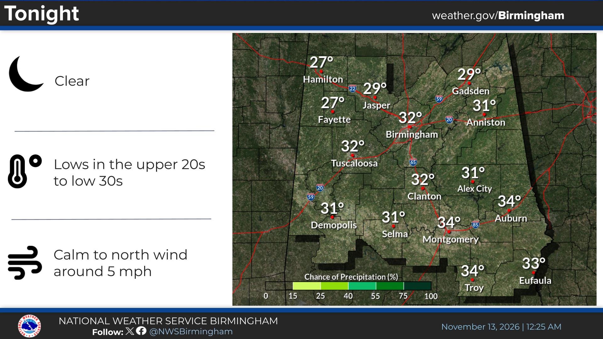
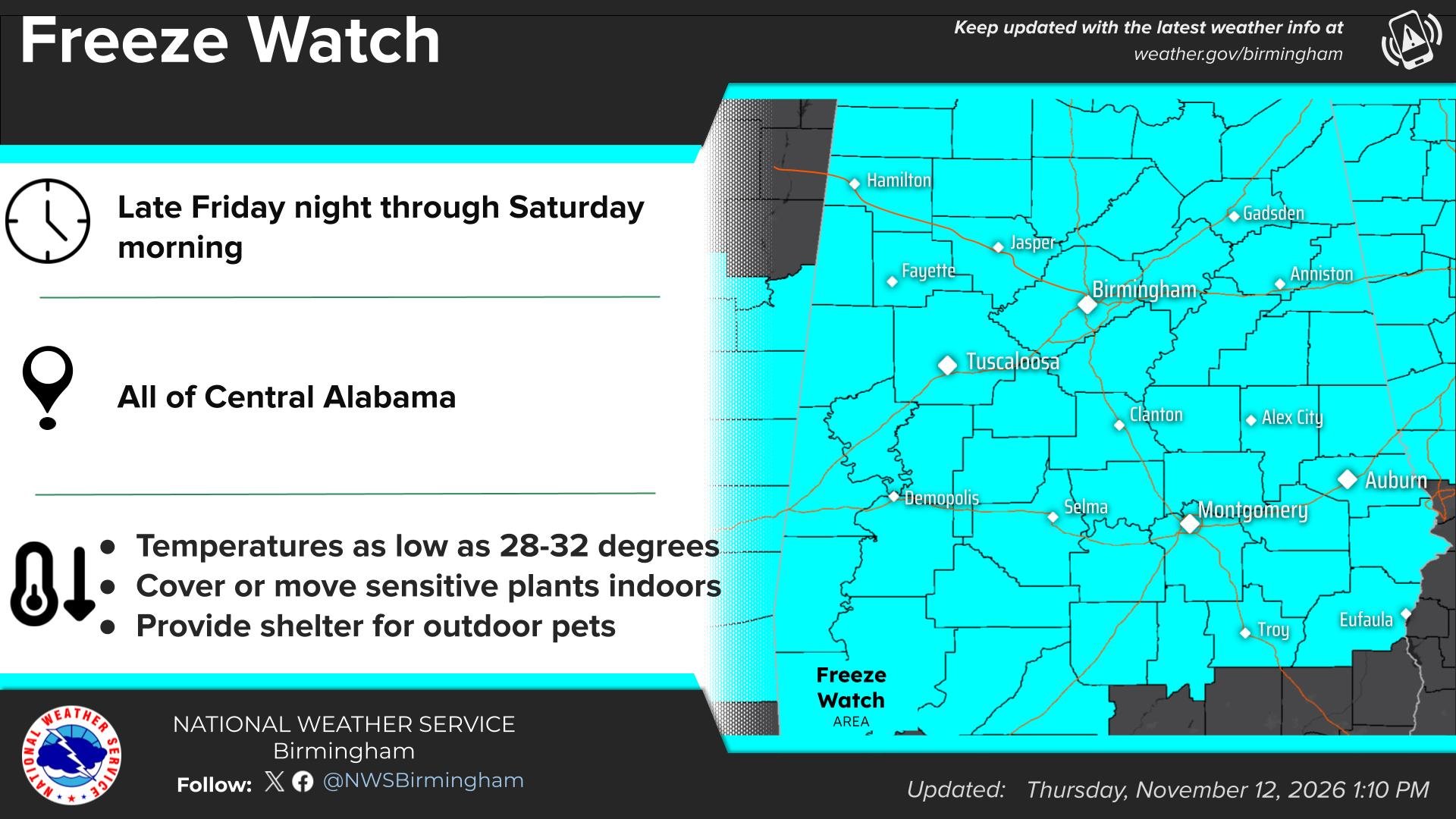
The Birmingham office said the warnings cover all of central Alabama, with lows of 28 to 32 degrees Saturday morning and 27 to 32 degrees Sunday morning, though some locations may stay just above freezing. The Huntsville office forecast lows as low as 26 degrees across northern Alabama, including Huntsville, Decatur, Florence, Athens and Cullman.
“Some of the coldest temperatures of the season” are expected Friday night, the Birmingham office said in its forecast discussion. It said skies would clear behind the front and winds would go calm overnight, allowing “widespread radiational cooling,” with lows in the upper 20s in some northern areas.
In a social media post Friday morning, the Birmingham office forecast sunny skies Friday with highs in the 50s and northwest winds of 10 to 20 mph, then a clear night “with a freeze across much of the area,” with lows from the upper 20s in the north to the low 30s in the south.
“The coldest air so far this season will roll into the Deep South today,” ABC 33/40 in Birmingham reported Friday. The station said temperatures would not get out of the 50s for most of Alabama on Friday and that Sunday morning should be just as cold as Saturday.
Farther south, the weather service office in Mobile posted a freeze watch from late Friday night through Saturday morning for Butler, Conecuh, Crenshaw, Monroe, Wilcox, Choctaw, Clarke and Washington counties in Alabama and Wayne County in Mississippi, with lows of 29 to 32 degrees possible.
Mississippi Expects Lows Near 28
In Mississippi, the weather service office in Jackson posted freeze warnings for both nights across a wide swath of the central and northern parts of the state, from Bolivar and Washington counties in the Delta east to Lowndes and Noxubee counties and south to Hinds, Rankin and Lauderdale counties.
The office said lows as low as 28 degrees are expected Friday night and Saturday night, with subfreezing temperatures likely from midnight to 8 a.m. both mornings.
Georgia’s First Freeze, Then a Hard Freeze
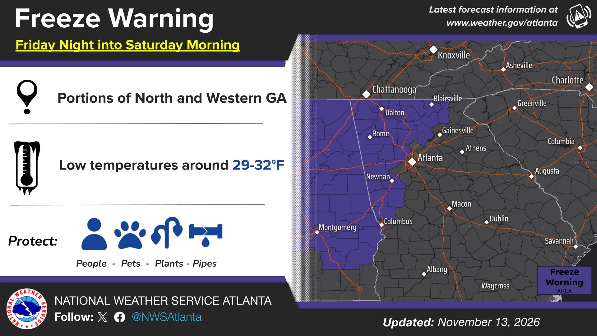
In Georgia, the weather service office in Peachtree City, which serves Atlanta, posted a freeze warning from 1 a.m. to 9 a.m. Saturday for north and west Georgia, including Rome, Dalton, Marietta, Carrollton, Newnan and Blue Ridge. Lows as low as 29 degrees are expected, with colder readings at higher elevations.
“Temperatures Friday night into Saturday morning will fall to below freezing for portions of north and west-central GA for the first time this season,” the Atlanta office said in a social media post.
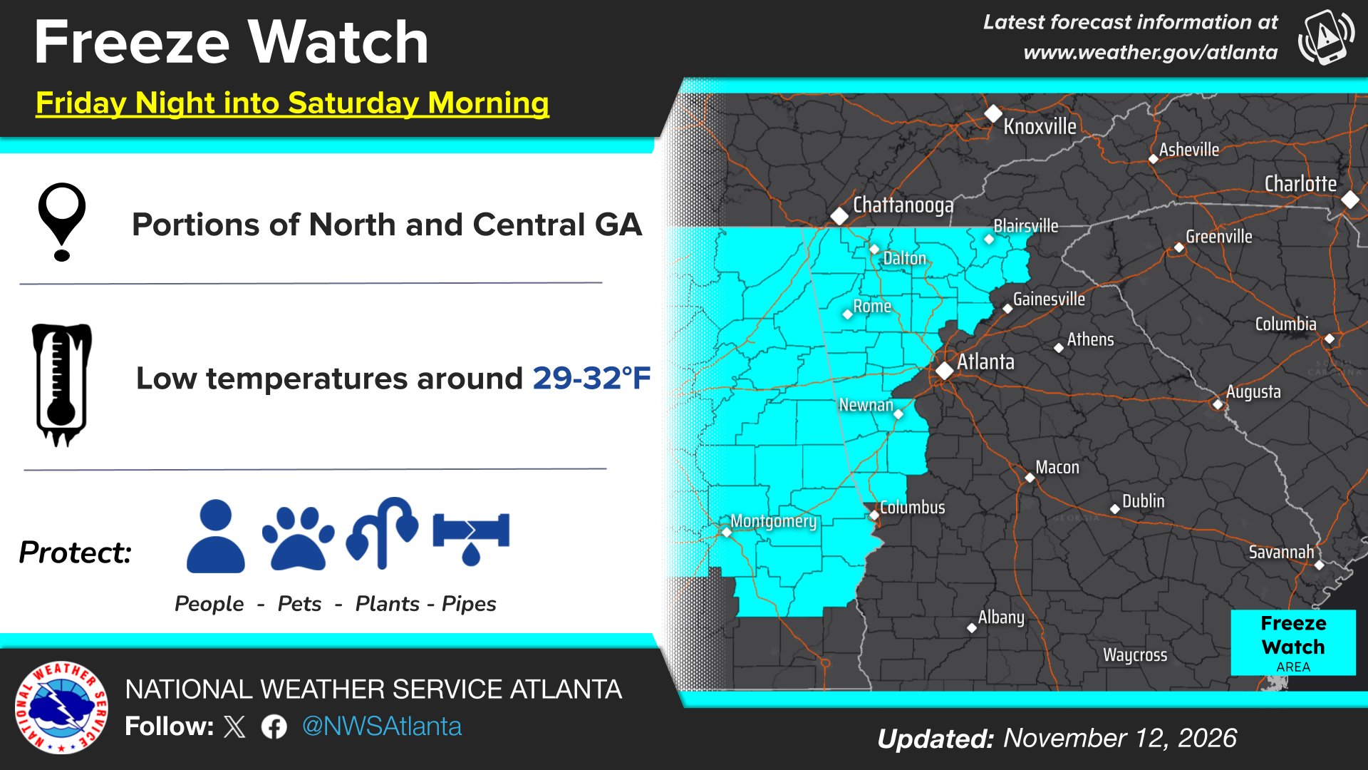
A freeze watch covers all of north and central Georgia, including metro Atlanta, for late Saturday night into Sunday morning, with lows as low as 25 degrees possible and colder in elevated spots.
Forecasters said Saturday night “should be the coldest night of the season so far.” They said the second freeze “should be a hard freeze for much of north Georgia into the metro,” with temperatures at or below 28 degrees.
The office said highs Friday and Saturday would reach only the 50s and 60s, and possibly only the 30s and 40s at higher mountain elevations, which it said is 10 to 15 degrees below average for many locations. Precipitation chances are “very close to zero,” it said, aside from a few possible flurries in the higher terrain of northeastern Georgia on Friday.
The timing matters for farmers and gardeners. Forecasters said the region is at the edge of the typical growing season, and the hard freeze “may bring an end to the frost/freeze program until the spring,” after consultation with state partners.
Atlanta News First reported that morning temperatures Friday had already dropped into the 30s and 40s across north Georgia, with highs struggling into the 50s and feels-like temperatures in the 40s most of the day.
Carolinas and Virginia Join In
The cold extends up the East Coast. The weather service office in Wakefield, Virginia, posted a freeze warning from 3 a.m. to 8 a.m. Saturday for parts of central, southern and southeastern Virginia and northeastern North Carolina, including Chesterfield and Henrico counties, with lows as low as 29 degrees.
In central North Carolina, the Raleigh office posted a freeze warning for the same hours for Durham, Orange, Guilford, Forsyth, Alamance, Chatham and several other counties, with lows near 30. A frost advisory covers Wake, Johnston, Cumberland and other counties farther south and east, where lows near 33 could produce frost, followed by a freeze watch Sunday morning.
Freeze watches for late Saturday night into Sunday morning also cover parts of central South Carolina and east-central Georgia, where lows near 30 are possible, the weather service office in Columbia said. Weather service offices serving the Charleston and Wilmington areas and eastern North Carolina posted similar watches for inland counties, with lows in the upper 20s to low 30s.
What to Do
The weather service warned that frost and freeze conditions could kill crops and other sensitive vegetation and possibly damage unprotected outdoor plumbing.
The Atlanta office urged residents to “protect the 4 P’s” — people, pets, plants and pipes. Forecasters recommended taking steps now to protect tender plants and, to keep water pipes from freezing, wrapping or draining them or letting them drip slowly.
The Birmingham office, marking Alabama’s Winter Weather Awareness Week, reminded residents to dress in layers, know the warning signs of hypothermia and not forget about pets. “Bring in sensitive plants and protect outdoor pets as well!” it said in a post Thursday.
Dry, Milder Weather to Follow
The cold snap is not expected to bring rain or snow. Forecasters in Birmingham said the region will remain mostly dry for the next seven days, though a closed low moving in Monday could bring low-end rain chances to southern areas.
By the middle of next week, a ridge of high pressure is expected to build overhead and push afternoon highs back into the upper 60s and low 70s across central Alabama, the Birmingham office said. Overnight lows will stay on the cool side as cold air continues to filter down the Appalachian Mountains, it said.
ABC 33/40 reported that the next chance of meaningful rain in Alabama is likely to come sometime during the week of Thanksgiving.
