Image: NOAA/National Weather Service Juneau
A storm-force low churning in the Gulf of Alaska drove a strong front into Southeast Alaska early Monday, bringing gusts up to 60 mph to Prince of Wales Island, seas up to about 40 feet offshore and up to a foot of snow to the upper Haines Highway, the National Weather Service said.
The weather service office in Juneau issued a high wind warning for Prince of Wales Island from 4 a.m. to 3 p.m. AKST Monday, calling for southeast winds of 20 to 30 mph and gusts up to 60 mph. The warning covers Craig, Hydaburg, Thorne Bay, Klawock and Coffman Cove.
“High winds will blow around unsecured objects, damage property and cause power outages,” the warning said. “Travel will be difficult.”
The strongest winds were expected along the island’s Gulf coast and southern end Monday morning through early afternoon, the weather service said.

A Deepening Low
In its Sunday evening forecast discussion, the Juneau office said the low was centered near 50 degrees north and 145 degrees west with a central pressure of about 965 millibars, and it was forecast to move northeast into the central Gulf and strengthen to 955 millibars overnight.
The low’s front would bring “a swath of southeasterly storm force sustained winds along the gulf coast starting late tonight and spreading north,” forecasters wrote. Gale-force winds were expected over much of the southern outer coast and up the inside channels Monday.
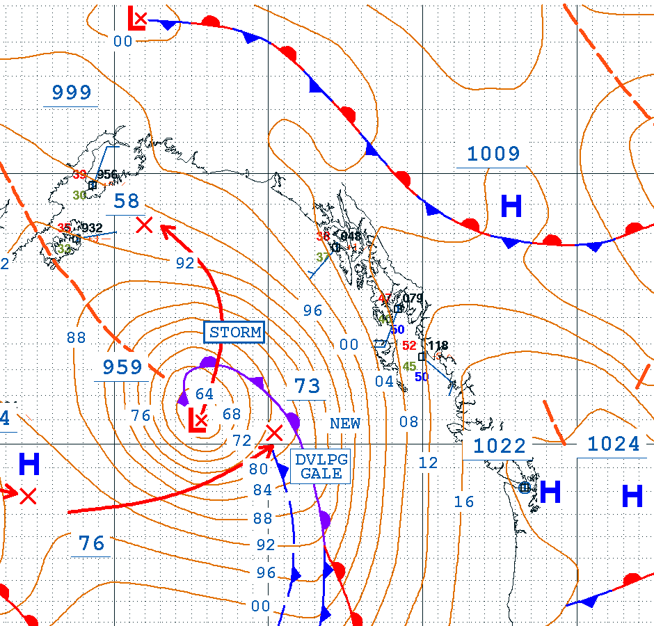
The Ocean Prediction Center’s analysis valid at 06:00 UTC Monday, or 9 p.m. AKST Sunday, showed the low at 959 millibars and labeled it a storm.
Wind Across the Southern Panhandle
Wind advisories cover much of the rest of the outer coast and southern Panhandle. Ketchikan, Annette Island and the western Kupreanof and Kuiu islands are under an advisory from 3 a.m. to 6 p.m. Monday for gusts up to 50 mph. Sitka’s advisory runs from 6 a.m. to 9 p.m. Monday, with gusts up to 50 mph and isolated gusts around 55 mph possible Monday afternoon.
In Yakutat, an advisory begins at 3 p.m. Monday and runs to 5 a.m. Tuesday. “A wind shift is expected to accompany the strongest winds Monday night with isolated gusts up to 55 mph possible,” the weather service said.
The winds were already building before dawn. The Sitka airport reported a gust of 39 mph at 2:20 a.m. AKST, and Ketchikan’s airport reported a gust of 34 mph at 2:53 a.m., according to weather service observations.
The Juneau office said the strongest winds should stay along the Gulf coast and not push far inland, but much of the interior Panhandle could still see gusts to 35 mph.
Air travel could also be affected. In its aviation forecast, the office said rain would push onto the coast overnight and spread northeast across Southeast Alaska by around daybreak, with flight conditions deteriorating as cloud ceilings dropped to 2,000 to 3,000 feet and visibility fell to 4 to 5 miles. The office’s briefing packet lists difficult travel for boats and planes among the expected impacts on Prince of Wales Island.
In a briefing packet issued Sunday afternoon, the office put the chance of gusts above 60 mph at 95% in Hydaburg at 9 a.m. Monday, 70% in Port Protection, 65% in Kasaan and 35% in Klawock.
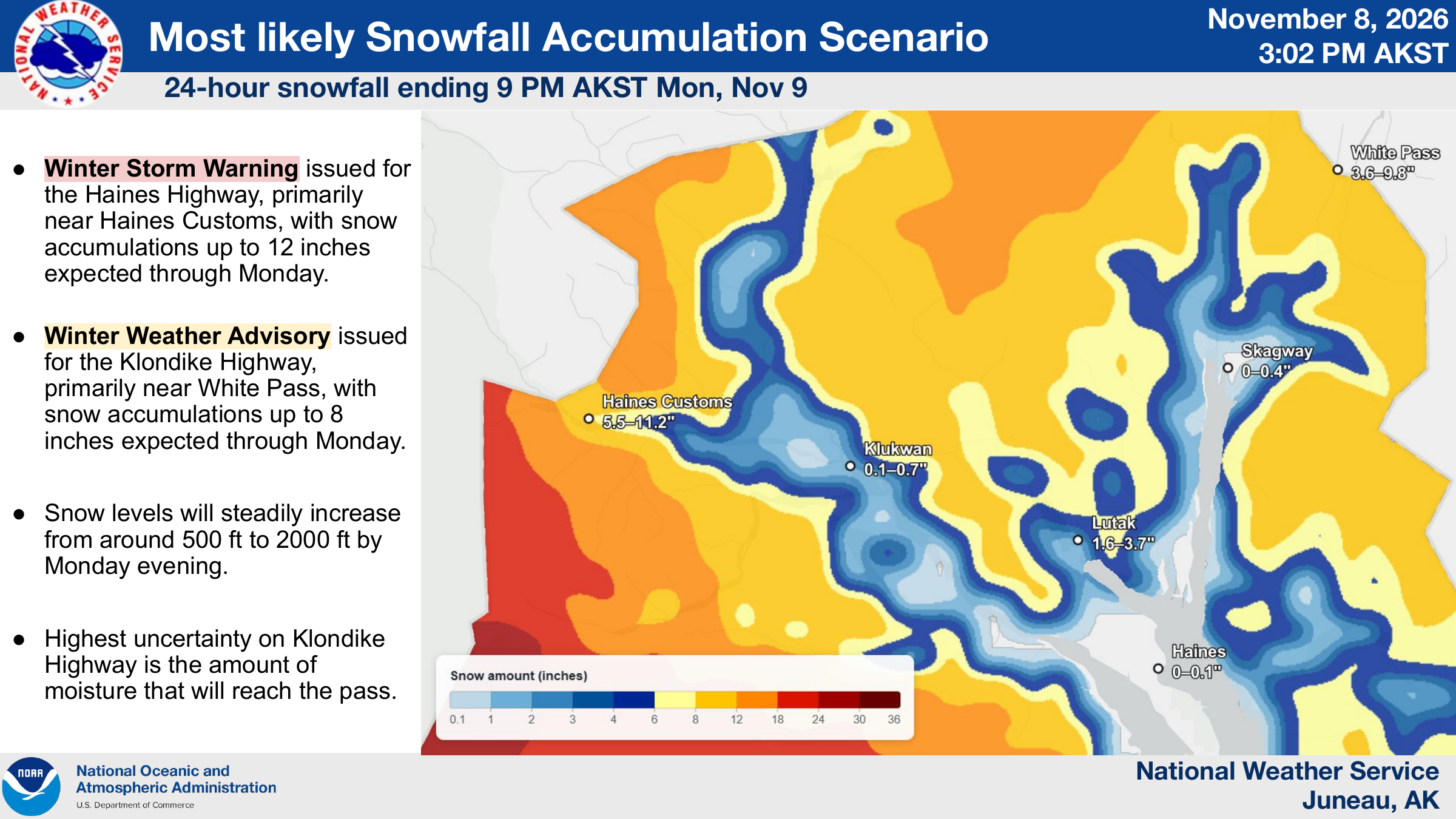
Image: NOAA/National Weather Service Juneau
Storm Warnings Offshore
The most dangerous conditions are on the water. In its 2:53 a.m. marine update Monday, the Juneau office kept storm warnings in effect for several outer coastal zones.
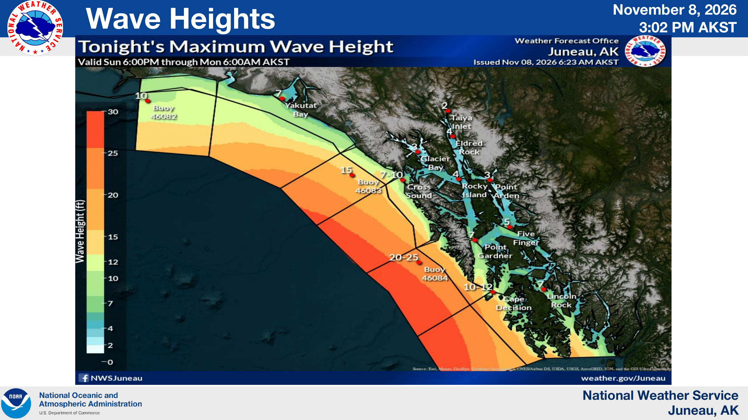
From Cape Fairweather to Icy Cape, 15 to 80 nautical miles offshore, the weather service forecast east winds of 40 to 60 knots with gusts up to 70 knots and seas of 37 to 42 feet until 9 p.m. Monday. From Dixon Entrance to Cape Decision, 15 to 90 nautical miles out, it forecast southeast winds of 35 to 55 knots with gusts to 70 knots and seas of 30 to 35 feet until noon.
Farther northwest, from Icy Cape to Cape Suckling, 15 to 80 nautical miles offshore, a storm warning takes effect from 9 a.m. Monday to midnight, with east winds of 40 to 60 knots, gusts up to 75 knots and seas of 37 to 42 feet. Between Cape Decision and Cape Edgecumbe, off Baranof Island, the storm warning runs until 3 p.m., with gusts up to 70 knots and seas of 32 to 37 feet. Gale warnings follow in most of those zones into early Tuesday.
In its briefing packet, the Juneau office said storm-force winds of 50 to 60 knots would develop over the Gulf and the Southeast Alaska coastal waters Sunday night and continue through Monday night, with wave heights building to more than 30 feet from the Baranof Island coast down to Dixon Entrance.
“Storm force winds and hazardous seas will capsize or damage vessels and reduce visibility,” the warnings said. “Mariners should remain in port, alter course, and/or secure the vessel for severe conditions.”
Inside waters were affected too. A gale warning for Clarence Strait, between Prince of Wales Island and the Ketchikan area, called for southeast winds of 35 to 45 knots with gusts up to 60 knots and seas of 13 to 18 feet until 6 a.m. Tuesday.
At 2:50 a.m. AKST, a National Data Buoy Center buoy off Cape Edgecumbe near Sitka measured waves of 3.5 meters, about 11.5 feet, with gusts of 22 meters per second, about 49 mph, as pressure fell 5.2 millibars in three hours.
Heavy Snow Near the Border
As the moisture pushes north, it is running into cold air at higher elevations near the Canadian border.
The winter storm warning for the upper elevations of the Haines Highway near Haines Customs runs from 3 a.m. to 6 p.m. Monday, with 8 to 12 inches of snow possible. “Travel could be very difficult,” the warning said. Snow levels will rise from about 500 feet to 2,000 feet by Monday evening, it said.
The Klondike Highway near White Pass is under a winter weather advisory for 5 to 8 inches, with gusts up to 25 mph causing blowing snow. Forecasters said southeasterly flow aloft should shelter White Pass from much of the precipitation, while the Haines border crossing “is expected to receive a decently potent swath of moisture which may result in up to a foot of snow in 24 hours.”
The weather service urged drivers to carry a flashlight, food and water and to check road conditions at 511.alaska.gov.
Rain and a Second Round
Rain is also part of the storm. The Juneau office forecast 0.75 to 1.25 inches in 24 hours on the outer coast and in the southern Panhandle.
A second low near 970 millibars is expected to move into the southern Panhandle Tuesday morning and afternoon, with rain at similar rates and slightly weaker gusts, forecasters said. The office’s briefing called for gusts up to 40 mph on Prince of Wales Island, Ketchikan and Annette Island on Tuesday and seas around 20 to 25 feet along the Prince of Wales coast.
More lows are expected to pass the Panhandle through Wednesday, followed by a break in the winds Thursday, the office said. Forecasters were watching another low that could cross the Gulf on Friday and Saturday, though they said its track and strength were uncertain. With cooler air spilling in from Canada late in the week, mixed precipitation will become more possible in places such as Haines and Skagway starting Thursday, they said.
The weather service asked residents to report damage at weather.gov/Juneau/StormReports.
