Image: Texas Game Wardens / Texas Parks and Wildlife Department
Runoff from a multiday soaking in South and West Texas pushed the Llano River out of its banks through the Hill Country early Tuesday. The river crested near Junction Monday night, while flood warnings remained in effect downstream at Mason and Llano as the rain ended.
The Llano River near Junction peaked at 20.65 feet at 8:50 p.m. CST Monday, according to U.S. Geological Survey readings posted by the National Weather Service. Flood stage there is 16 feet and moderate flood stage is 22 feet. The weather service had forecast a crest of 20.4 feet and said in its warning that the crest compared with a previous crest of 20 feet on Oct. 19, 1985.
By 6 a.m. Tuesday, the river near Junction had dropped to about 16.4 feet, just above flood stage. The weather service’s flood warning for that gauge in Kimble County runs until 3:45 p.m. Tuesday.
Downstream, the water was still arriving. The Llano River near Mason reached 19.13 feet at 5:35 a.m. Tuesday, above its 18-foot flood stage and higher than the 18.3-foot crest the weather service had forecast Monday evening. Flooding at that level covers secondary roads and low-water crossings, according to the warning for Mason County.
Farther east, the Llano River at Llano stood at 11.74 feet at 6 a.m. Tuesday and was rising. Flood stage there is 10 feet. The weather service’s Austin/San Antonio office upgraded its forecast Monday from minor to moderate flooding and called for a crest near 13.2 feet Tuesday morning. Its warning is in effect until 6 a.m. Wednesday.
At 12 feet, the warning said, “moderate lowland flooding makes secondary roads and low bridges in the flood plain dangerous to motorists.” That includes the low-water crossing of Ranch Road 3404, known locally as the Slab, near Kingsland. The warning also advised people to move equipment from low docks and loosen boat ties downstream in Kingsland.
The water is headed into the Highland Lakes. The Lower Colorado River Authority said Monday that it expected to open at least one floodgate at both Wirtz and Starcke dams Tuesday morning “to move floodwaters downstream into Lake Travis.” LCRA said heavy rain west of the Highland Lakes was causing high flows along parts of the Llano River, which flows into Lake LBJ. KVUE-TV reported that LCRA did not expect to open additional floodgates.
Rescues and Closed Roads
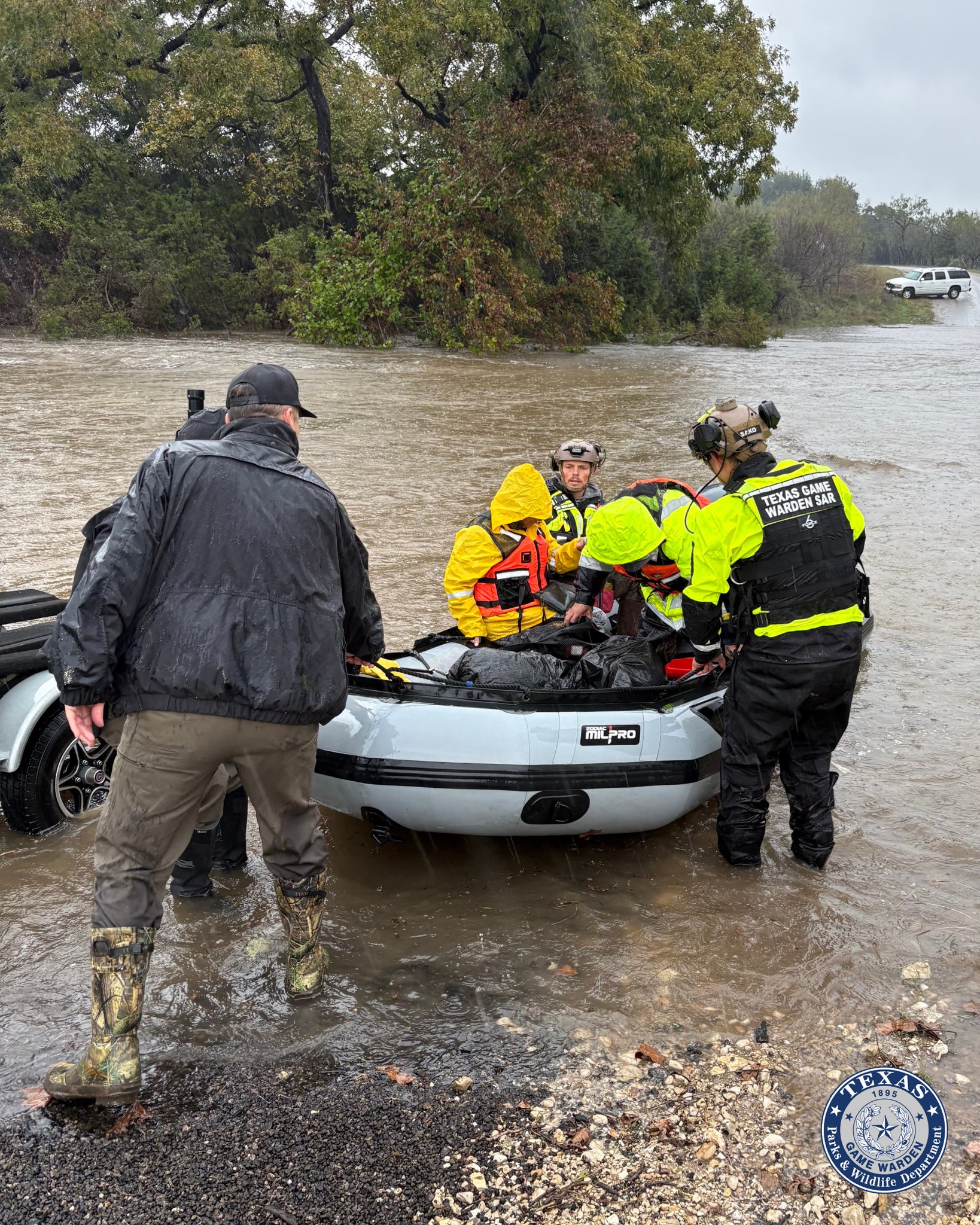
The flooding turned dangerous for drivers in Kimble County on Monday. Members of the Texas Game Warden Search and Rescue Team rescued a man and a woman who had been stranded after their vehicle was swept downstream by floodwaters, the Texas Game Wardens said in a social media post Monday afternoon. The agency did not release the names of the people rescued or the exact location.
“Never attempt to drive through flooded roadways. Turn Around, Don’t Drown,” the agency said.
At 6:20 p.m. Monday, the Kimble County Sheriff’s Office reported that the Flatrock Lane bridge near Junction was closed because of flooding, according to a weather service storm report. The sheriff’s office also reported that U.S. 377 was closed south of Junction, where low-water crossings were flooded. Ranch roads 2291, 3480, 385, 2169 and North Ranch Road 1674 were closed as well.
Earlier Monday, the emergency manager in Edwards County reported water over roadways, including U.S. 377 and Ranch Road 674, after prolonged steady rain, the weather service said. Some spots had 2.5 feet of water.
The trouble began over the weekend. A flash flood warning update issued at 7:46 p.m. CST Sunday for parts of Edwards, Kinney and Val Verde counties said a water rescue had been reported that evening in the Newby Hills subdivision along County Road 450, according to a summary of the warning published by weather news site Air Sports Net. The same warning said 2 to 5 inches of rain had fallen in the warned area over the previous 24 to 36 hours.

Image: Texas Game Wardens / Texas Parks and Wildlife Department
How Much Rain Fell
The weather service office in San Angelo said Monday that 2 to 4 inches of rain was common across west-central Texas south of a line from San Angelo to Ivie Reservoir. A gauge operated by the Lower Colorado River Authority 17 miles northwest of Junction measured 4.49 inches through about midday Monday. Junction recorded 3.56 inches, and a West Texas Mesonet site 23 miles southeast of Sonora recorded 4.04 inches. Rain was still falling when the office posted those numbers.
DailyTrib.com, a Highland Lakes news site, reported that tributaries of the Llano River farther west, in Kimble, Sutton and Edwards counties, received more than 5 inches of rain over the past week, citing LCRA’s Hydromet network. That left the river already swollen before the final rounds of rain fell across its basin.
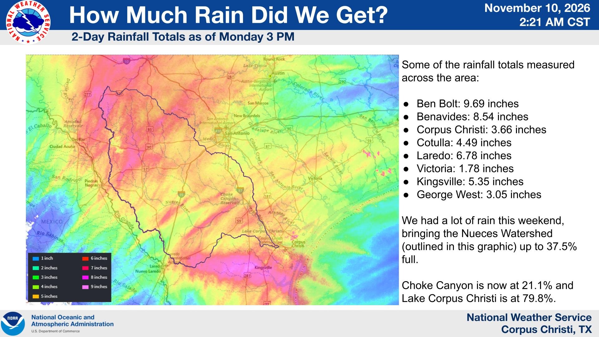
The heaviest totals of the storm fell much farther south. In a list of two-day rainfall totals through 3 p.m. Monday, the weather service in Corpus Christi reported 9.69 inches 4 miles south of Ben Bolt in Jim Wells County. A site 5 miles southwest of Benavides and another 8 miles north of Premont each recorded 8.54 inches. A gauge 2 miles north of Laredo measured 6.78 inches, and Kingsville recorded 5.35 inches.
Not every flood forecast came true. Oso Creek near Corpus Christi had been forecast over the weekend to rise above its 20-foot flood stage. The creek peaked at 11.64 feet Sunday afternoon and measured 10.79 feet early Tuesday, gauge data show. That is well below flood stage.
The rain also added water to area reservoirs. The Corpus Christi office said early Tuesday that the weekend rain had brought the Nueces watershed “up to 37.5% full,” with Choke Canyon Reservoir at 21.1% and Lake Corpus Christi at 79.8%.
State Response
Gov. Greg Abbott directed the Texas Division of Emergency Management on Nov. 6 to mobilize more state emergency response resources ahead of the rain, including swift-water rescue boat squads, game wardens and helicopters with hoists.
“I urge all Texans to remain weather-aware, monitor local forecasts, avoid flooded roadways, and heed guidance from state and local officials,” Abbott said in a statement at the time.
Drier Days Ahead
The storm system behind the rain is moving away. The weather service’s Austin/San Antonio office said early Tuesday that the upper-level storm system over the state was “broadening out” and would exit to the northeast. It said the remaining showers would be “a far cry from the widespread rains we had seen during the past few days.”
The San Angelo office said radar showed only a few isolated, light showers early Tuesday, with patchy fog likely through the morning.
Near the coast, the Corpus Christi office kept a 20% to 40% chance of rain through Wednesday morning. It said up to 1 to 2 inches more was possible near the Coastal Bend through Tuesday evening. A coastal flood advisory was in effect Tuesday morning along parts of the middle Texas coast.
A dry cold front is expected to cross the region Wednesday, bringing sunny skies, lower humidity and cooler mornings through Friday, according to the San Angelo and Austin/San Antonio offices. The next chance of rain, 30% to 60% in the Austin/San Antonio area, returns late Saturday into Sunday.
The weather service said that until the rivers fall, drivers should not go around barricades or try to cross flooded roads. “Turn around, don’t drown when encountering flooded roads,” its flood warnings said. “Most flood deaths occur in vehicles.”
