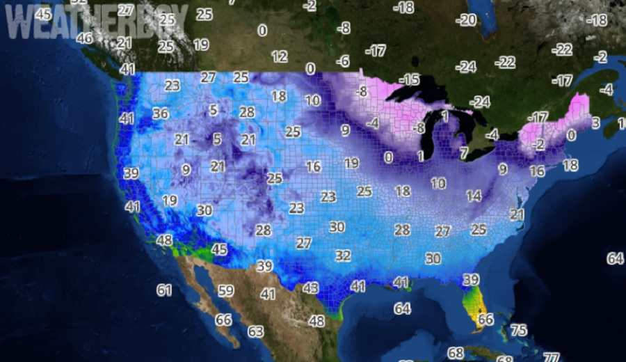
Freezing cold temperatures are about to plunge into the United States, bringing about some of the coldest low temperatures seen this season –and for some, in several years. While central and southern Florida will stay mild, as will extreme southern California and Arizona, much of the country will see readings at or below the freezing mark; across the Upper Plains and northern New England, temperatures will even dip well below zero degrees Fahrenheit.
This morning, a potent cold front exited the U.S. East Coast into the eastern Atlantic Ocean, allowing for Arctic air to rush into the Northeast. This pocket of cold air extends westward and throughout much of the northern tier, where dangerously cold wind chills will remain across the Upper Midwest and Great Lakes today before more bearable temperatures enter on Tuesday. With wind chills expected to drop well below zero, with some readings as frigid as -40, Wind Chill Warnings and Wind Chill Advisories currently span 12 states throughout the northern tier from far northeast Montana to northern Maine.
Temperatures this cold can lead to frostbite on exposed skin in as little as ten minutes. For much of the Northeast and New England, these frigid temperatures will remain locked over the region into Wednesday morning as a strong high pressure system slowly swings over the eastern United States.
Meanwhile, as cold west-northwesterly winds blow across the Great Lakes Region, significant lake effect snow is likely down-wind of the Great Lakes over the next few days. Snow could be particularly heavy at times under very narrow snow bands throughout the eastern Upper Peninsula of Michigan, the Tug Hill Plateau of New York State, as well as far western New York and northwest Pennsylvania. The heaviest snow is expected across the Tug Hill, where over a foot of snow is possible. Due to the threat of heavy snow in these areas, the National Weather Service has issued Winter Storm Warnings, Lake Effect Snow Warnings, and Winter Weather Advisories.
