Unfortunately, a fresh catastrophe is unfolding for Florida as yet another powerful tropical cyclone takes aim on the Sunshine State. Early today, a tropical depression formed in the Gulf of Mexico and quickly became Tropical Storm Milton. It is now expected to go through a period of rapid intensification, becoming a major hurricane before it strikes the Florida Gulf Coast. Some areas in the potential landfall zone include those still recovering from Major Hurricane Helene which struck there just a week ago.
“There is an increasing risk of life-threatening storm surge and wind impacts for portions of the west coast of the Florida Peninsula beginning late Tuesday or Wednesday,” warns the National Hurricane Center based in Miami, Florida. “Residents in these areas should ensure they have their hurricane plan in place, follow any advice given by local officials, and check back for updates to the forecast.”
Not good at all. #HurricaneMilton pic.twitter.com/ktxmWV1Kji
— the Weatherboy (@theWeatherboy) October 5, 2024
As was the case in the days before Helene, a weather system will soak Florida even before this new storm arrives. “Areas of heavy rainfall will impact portions of Florida Sunday and Monday well ahead of Milton, with heavy rainfall more directly related to the system expected later on Tuesday through Wednesday night,” the National Hurricane Center said. “This rainfall brings the risk of flash, urban, and areal flooding, along with minor to moderate river flooding.”
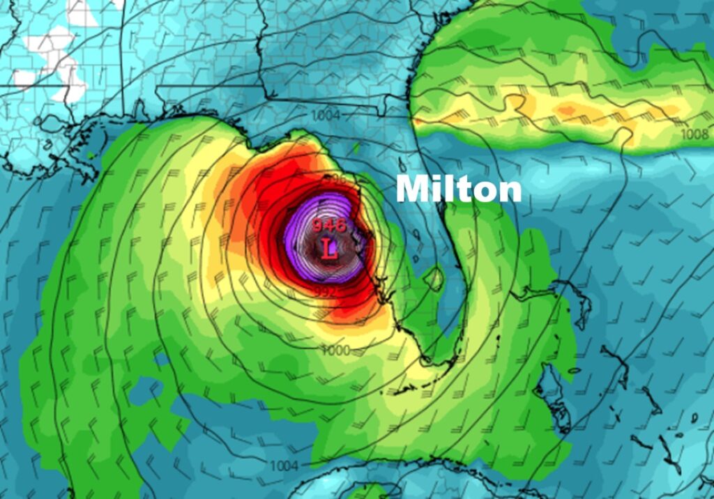
For now, Tropical Storm Milton has maximum sustained winds of 40 mph and a minimum central pressure of 1006 mb. Milton is moving toward the north-northeast near 3 mph. According to the National Hurricane Center, a slow east-northeastward motion is expected to begin tonight. A slightly faster eastward to east-northeastward motion is forecast by Monday and Tuesday. On the forecast track, the storm is forecast to remain over the southwestern Gulf of Mexico through Sunday night, then move across the south-central Gulf of Mexico on Monday and Tuesday, and approach the west coast of the Florida Peninsula by midweek. Steady to rapid strengthening is forecast during the next few days and Milton is forecast to become a hurricane Sunday night. The National Hurricane Center said it could become a major hurricane while it moves across the central and eastern Gulf of Mexico, packing winds over 110 mph.

Extremely heavy rain is expected over Florida. Rainfall amounts of 5-8″ with localized totals up to a foot, are expected across portions of the Florida Peninsula and the Keys through Wednesday night. This rainfall will bring the risk of flash, urban, and areal flooding, along with minor to moderate river flooding.
Swells generated by the system will begin to affect the coast of the southwestern Gulf of Mexico today. These swells are expected to spread northward and eastward along much of the Gulf Coast by early next week. These swells are likely to cause life-threatening surf and rip current conditions.
There are no Tropical Storm or Hurricane Watches up for Florida yet, but that is likely to change on Sunday when the National Hurricane Center is expected to issue them.
