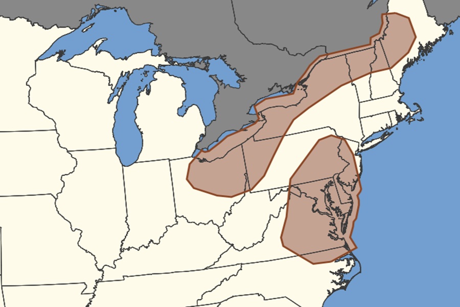
Severe thunderstorms are expected to blossom across portions of the Mid Atlantic and Northeast this afternoon and evening and the National Weather Service’s Storm Prediction Center (SPC) is warning of the threat of hail from these storms. The greatest hail threat from these storms is over Delaware, much of New Jersey and Maryland, portions of Pennsylvania, Virginia, Ohio, Upstate New York, and northern New Hampshire, Vermont, and Maine.
The National Weather Service officially defines a severe thunderstorm as one capable of producing hail that is 1 inch in diameter or larger, which is about the size of a quarter. Hail smaller than 1 inch is considered non-severe or “small” hail.
Hail is a form of precipitation consisting of solid ice that forms inside thunderstorm updrafts. It’s formed when raindrops are carried upward by thunderstorm updrafts into extremely cold areas of the atmosphere and freeze. Hailstones then grow by colliding with liquid water drops that freeze onto the hailstone’s surface. If the water freezes instantaneously when colliding with the hailstone, cloudy ice will form as air bubbles will be trapped in the newly formed ice. However, if the water freezes slowly, the air bubbles can escape and the new ice will be clear. The hail falls when the thunderstorm’s updraft can no longer support the weight of the hailstone, which can occur if the stone becomes large enough or the updraft weakens.
Hailstones can have layers of clear and cloudy ice if the hailstone encounters different temperature and liquid water content conditions in the thunderstorm. The conditions experienced by the hailstone can change as it passes horizontally across or near an updraft. The layers, however, do not occur simply due to the hailstone going through up and down cycles inside a thunderstorm. The winds inside a thunderstorm aren’t simply up and down; horizontal winds exist from either a rotating updraft, like in supercell thunderstorms, or from the surrounding environment’s horizontal winds.
Hailstones also do not grow from being lofted to the top of the thunderstorm. At very high altitudes, the air is cold enough that all liquid water will have frozen into ice, and hailstones need liquid water to grow in size.
Hail falls when it becomes heavy enough to overcome the strength of the thunderstorm updraft and is pulled toward the earth by gravity. Smaller hailstones can be blown away from the updraft by horizontal winds, so larger hail typically falls closer to the updraft than smaller hail.
Wind-driven hail can tear up siding on houses, break windows and blow into houses, break side windows on cars, and cause severe injury and/or death to people and animals.
Hail size is often estimated by comparing it to a known object. Most hailstorms are made up of a mix of different sizes, and only the very largest hail stones pose serious risk to people caught in the open. When reporting hail, estimates comparing the hail to a known object with definite size are good, but measurements using a ruler, calipers, or a tape measure are best.
Common sizes of hail:
-Pea = 1/4 inch diameter
-Mothball = 1/2 inch diameter
-Penny = 3/4 inch diameter
-Nickel = 7/8 inch
-Quarter = 1 inch — hail quarter size or larger is considered severe
-Ping-Pong Ball = 1 1/2 inch
-Golf Ball = 1 3/4 inches
-Tennis Ball = 2 1/2 inches
-Baseball = 2 3/4 inches
-Tea cup = 3 inches
-Softball = 4 inches
-Grapefruit = 4 1/2 inches
