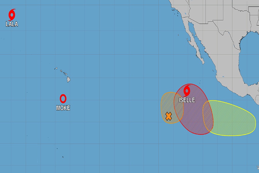
Tropical Storm Moke weakened to a tropical depression today after passing well south of the Big Island of Hawaii. While the center of the storm passed south of Hawaii, gusty winds and heavy rains continue to lash portions of Hawaii due to the system’s close proximity. While Moke won’t be much of a threat to Hawaii moving over, the National Hurricane Center is monitoring other storms or storm threats in the Pacific.
As of the latest advisory from the Central Pacific Hurricane Center, Moke was located about 335 miles south-southwest of Hilo on the Big Island of Hawaii. Winds were down to 35 mph while pressure was up to 1003 mb or 29.62″. The tropical depression is moving toward the west near 14 mph away from the Big Island of Hawaii and this general motion is expected by the Central Pacific Hurricane Center to continue during the next several days. On the forecast track, the center of Moke is expected to pass south and southwest of the Big Island of Hawaii tonight, then well south of the smaller main Hawaiian Islands tonight and Monday.
While not impacting Hawaii directly, Moke will continue to bring scattered heavy downpours and gusty winds to the eastern part of the state. Gusty winds are likely across the Hawaiian Islands during the next couple of days, especially in areas of high terrain. Tropical Depression Moke is expected to produce additional rainfall totals of 3-6″ through Monday across the Big Island and eastern Maui. These rainfall amounts may produce life-threatening flooding and mudslides for the windward and southeast Big Island, especially in steep terrain and over areas that were affected recently by Lala. Across western Maui and the remainder of the islands, moisture drawn northward from Tropical Depression Moke may bring up to 1 or 2 inches of rain.
There are two other named systems in the Central and Eastern Pacific: Tropical Storms Lala and Iselle. Neither of these systems is forecast to impact land anymore.
Beyond those 2 named systems, the National Hurricane Center and Central Pacific Hurricane Center are keeping an eye on 3 other areas that could become named systems over time.
The first system is in the central east Pacific. Disorganized showers and thunderstorms are persisting with a broad area of low pressure located well to the south-southwest of the southern tip of the Baja California Peninsula. According to the National Hurricane Center, environmental conditions could support the development of a short-lived tropical depression during the next day or so before it becomes absorbed by Tropical Storm Iselle. There’s only a 40% chance the system will develop within the next 48 hours.
The next system of concern is currently located well southwest of southwestern Mexico. An area of low pressure is expected to develop well south of the southern tip of the Baja California Peninsula toward the middle portion of the week. Some slow development is expected thereafter, and the National Hurricane Center says that a tropical depression is likely to form later this week or over the weekend while the system moves generally west northwestward. Of the systems in the Pacific, this is the most likely to develop; the National Hurricane Center says there’s a 70% chance of tropical cyclone formation over the next 7 days.
The third area of concern is located offshore southern Mexico. According to the National Hurricane Center, another area of low pressure could form well offshore of Central America late this week. Environmental conditions appear favorable for gradual development over the weekend as the system moves westward to west-northwestward at 10 to 15 mph well offshore of southern Mexico. But odds are relatively low for now for formation, with the National Hurricane Center only giving the system a 20% chance of developing into a tropical cyclone over the next 7 days.
