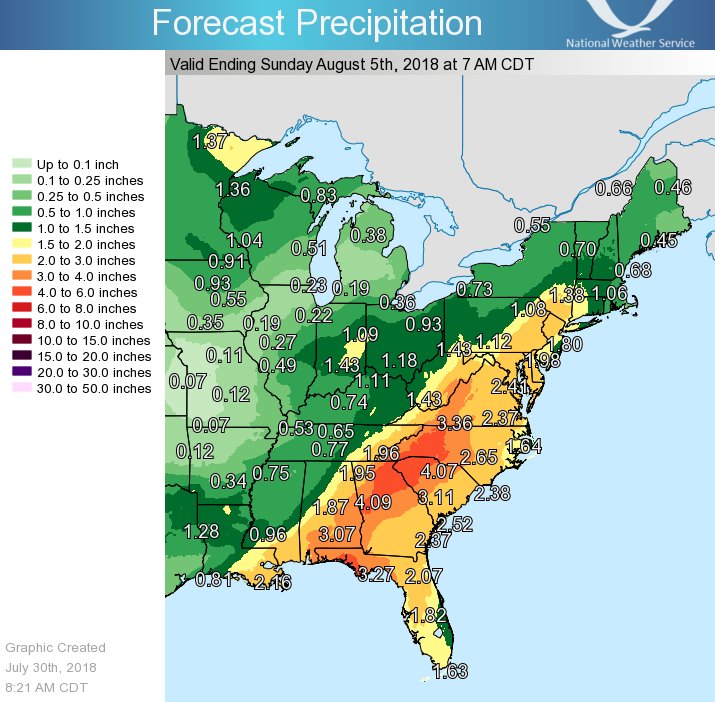
After a brief weekend respite that interrupted many days in a row of heavy, soaking rains to portions of the East Coast, it looks like more rains are returning. Today, a warm front extended from the middle Mississippi River Valley to the waters off the Middle Atlantic coast. The warm front is forecast to lift northward and through the Mid Atlantic on Tuesday. Another frontal boundary is expected to approach slowly from the west to the Mid Atlantic on Wednesday and Thursday, stalling and becoming weak in the Mid Atlantic from Friday into the weekend as high pressure builds westward from the western North Atlantic. These movements will set the stage for another round of heavy rain in the the Eastern U.S.
Unlike last week’s weather pattern that brought round after round of heavy rain to portions of Maryland and Pennsylvania, the focus area of the heavy rain from the next seven days should shift south over portions of Florida, Alabama, Georgia, and North and South Carolina. While the heavy rain will be focussed there, soaking rains are expected elsewhere along the East Coast from Florida to New England; the I-95 corridor from Virginia to New York will be quite wet too.
Be sure to visit our Flood Information Center so that you are prepared before any threat arrives.
