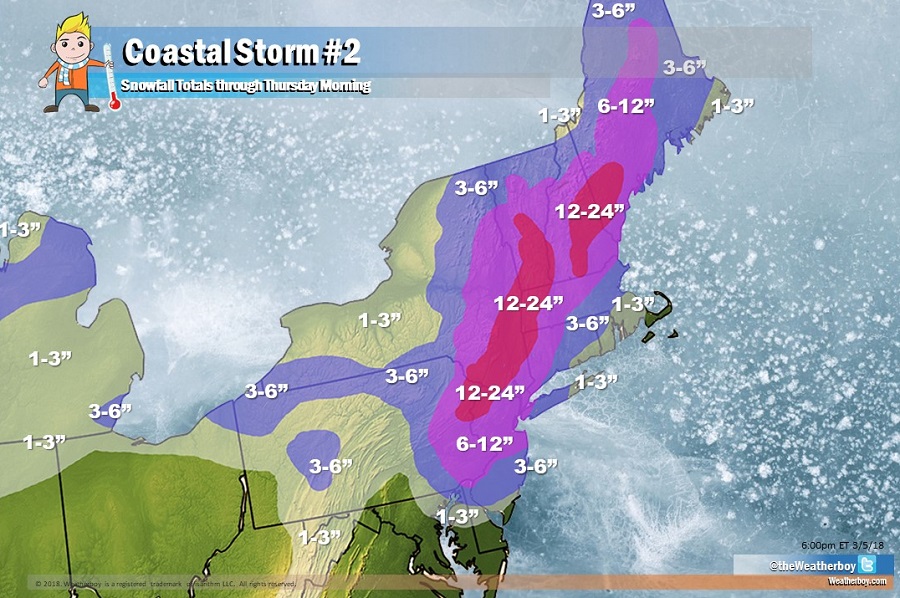
Just days after a powerful Monster March storm brought hurricane force gusts and heavy precipitation across the northeast, leaving tens of thousands in the dark and 9 dead, it appears Old Man Winter is about to strike the region again. And to make matters worse, it appears a third system is also in the atmospheric pipeline for impact at the end of the upcoming weekend or early next week.
The weather in the Mid Atlantic and Northeast will begin to go downhill on Tuesday. During the day, a shortwave ridge aloft will move across the region as a rather strong upper trough approaches from the Midwest. Light variable winds in the morning will become light southerly in the afternoon as the surface ridge moves offshore. Clouds and moisture will be increasing in the afternoon from southwest to northeast, with light rain or snow possible as early as late afternoon as far north and east as Philadelphia County in eastern Pennsylvania.
The main event will unfold later tomorrow night and Wednesday, with the most potent ingredients coming together during the later afternoon hours on Wednesday. Prior to that “main event”, rain or a mix of rain and snow is possible south of I-195 in New Jersey and south of I-676 in Pennsylvania. But during the main event, any mixed precipitation there will become all snow with snow, heavy at times, expected further north into the northeast. While short-lived, this will be an intense snow-maker with snowfall rates approaching 2″/hour in portions of eastern Pennsylvania, northern half of New Jersey, and southeastern Upstate New York. Some thunderstorms with snow are also possible; remember: when thunder roars, head indoors; lightning can kill in any weather, including snow. The heaviest snow between Philadelphia and New York City should be during what is usually the PM rush hour on Wednesday; that heavy snow area will shift north and east towards Boston and north/west suburbs of Boston later Wednesday night.
Winds will also be gusty as the storm intensifies off the East Coast on Wednesday. Blizzard conditions are possible. Blizzard conditions are met when there’s falling or blowing snow, winds sustained at 35mph for 3 hours+, and visibility no greater than 1/4 mile for 3+ hours.
Residents in the northeast should expect additional power outages. The consistency of the snow will be wet and heavy again, putting weight onto trees and wires already stressed by recent storms. With gusty winds added to the mix, trees, limbs, and wires will tumble again.
There’s a risk of minor to moderate coastal flooding from this storm, especially around New Jersey, New York, and Massachusetts. While problematic, the extent of flooding should not be as severe as it was from Friday’s Monster March storm.
As the storm pulls out late Wednesday, conditions will gradually improve from southwest to northeast. However, lingering atmospheric instability will continue to produce snow showers and squalls across the Great Lakes and northern New England into Thursday.
By the time the storm is done, a wide variety of snowfall amounts will be reported. In Delaware, there could be nearly a foot difference in accumulations from north to south; the northern border could see close to a foot while the south beaches may only see rain or a non-accumulating wintry mix of rain and snow. In New Jersey, a more drastic difference will unfold: portions of Cape May will see rain or a non-accumulating rain/snow mix for most of the storm; meanwhile, the northwestern part of the state could see 1-2 feet of snow. Philadelphia and New York City should both see heavy snow, with 6-12″ expected there. The lower amount of that range will fall in the urbanmost areas of those metro zones; higher amounts will fall on the north west side of those metro zones. While western Long Island near New York City will see 6-12″, eastern Long Island may only see 1-3″ due to more rain mixing in. Across Cape Cod and nearby islands, rain will also be the dominant precipitation type.
Once this storm clears the northeast, attention will be paid to the third storm of this series. That third storm could produce another round of heavy precipitation, high winds, and coastal flooding threats as early as the end of the upcoming weekend or early next week. March isn’t a stranger to big snows in the northeast; over time, there have been many blockbuster snowstorms in the third month.