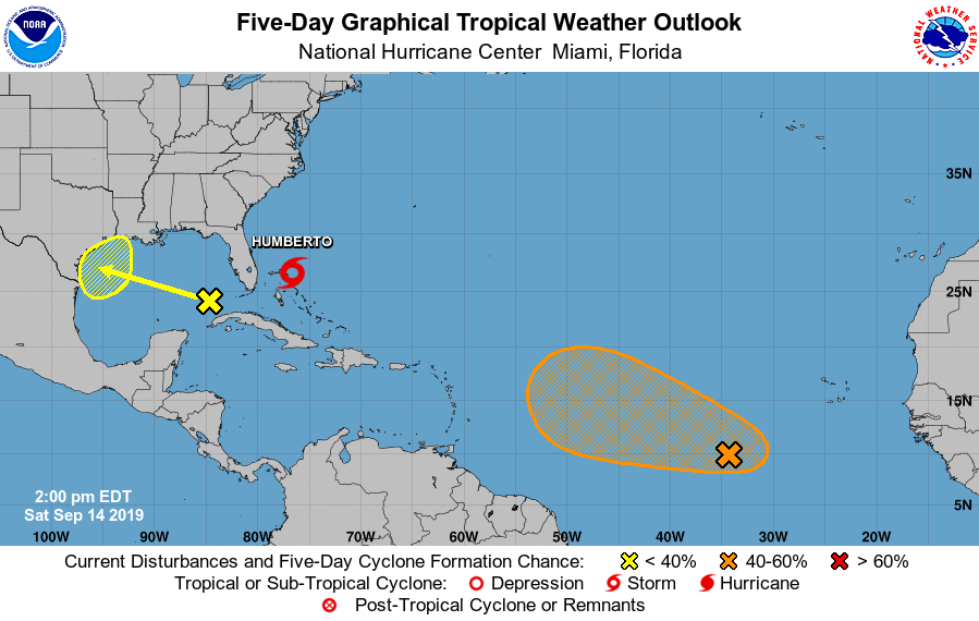
Tropical Storm Humberto is gaining strength near the areas hit hard by Hurricane Dorian just weeks ago in the Bahamas; while it is forecast to become a hurricane soon, two other areas of concern have attracted the attention of the National Hurricane Center.
The National Hurricane Center is issuing advisories on Tropical Storm Humberto, centered just east-northeast of the northwestern Bahamas. While they dropped watches along the Florida coast last night, the Bahamas are continuing their Tropical Storm Warning for the northwest Bahamas except for Andros Island. After several hours of meandering, Humberto has begun to move toward the northwest at 7 mph and this general motion with gradual turn to the north is expected by the National
Hurricane Center during the next day or so. A sharp turn to the northeast is expected on Monday. On the forecast track, the center of Humberto should gradually move away from the northwestern Bahamas today or tonight, and then move well offshore of the east coast of Florida this weekend and early next week. Maximum sustained winds are near 50 mph with higher gusts. Humberto is forecast to become a hurricane by Sunday night well east of the east coast of Florida.
While Humberto spins about east of Florida, another area is being watched west of Florida. A large area of cloudiness and showers over the eastern Gulf of Mexico is associated with an upper-level low and a weak surface trough. Only slow development of this system is likely during the next couple of days while it moves westward over the western Gulf of Mexico. This system is forecast to move inland along the northwestern Gulf coast by late Monday or Tuesday and development is not expected after that time. The National Hurricane Center believes there’s a 30% chance that this system will grow into a tropical cyclone over the next 5 days.
While there’s a low chance of tropical cyclone formation in the Gulf of Mexico, there’s a better chance that a system in the Atlantic will form next. An elongated area of disturbed weather is located about 750 miles southwest of the Cabo Verde Islands. According to the National Hurricane Center, gradual development of this system is possible during the next several days, and a tropical depression could form by the middle of next week while it moves westward across the tropical Atlantic. Unlike the system in the Gulf, the National Hurricane Center believes there’s a 60% chance that this system will evolve into a tropical cyclone over the next 5 days.
