• Skip to primary navigation
  • Skip to main content
  • Skip to primary sidebar

Weatherboy

Weatherboy Weather News, Maps, RADAR, Satellite, and Forecasts.

  • Local
  • Earth Science News
  • RADAR
  • Current Warnings
  • Satellite
  • Current Maps
  • Forecast Maps
  • Video

Hurricane Center Increases Odds of East Coast Tropical Cyclone Forming

by Weatherboy Team Meteorologist - June 27, 2021

The latest satellite loop from the GOES-East weather satellite shows the disturbance in the eastern Atlantic heading west to the U.S. southeast coast. Image: NOAA

The National Hurricane Center (NHC) in Miami, Florida has increased odds that an area of low pressure well south of New Jersey and well east of Georgia will become a tropical cyclone in the coming days. Even if a tropical cyclone doesn’t materialize, the system is still on a collision course with the East Coast and will bring rain and gusty winds to the coast by late tomorrow night. The NHC says an Air Force Reserve Unit reconnaissance aircraft is scheduled to investigate this system tomorrow afternoon, if necessary.
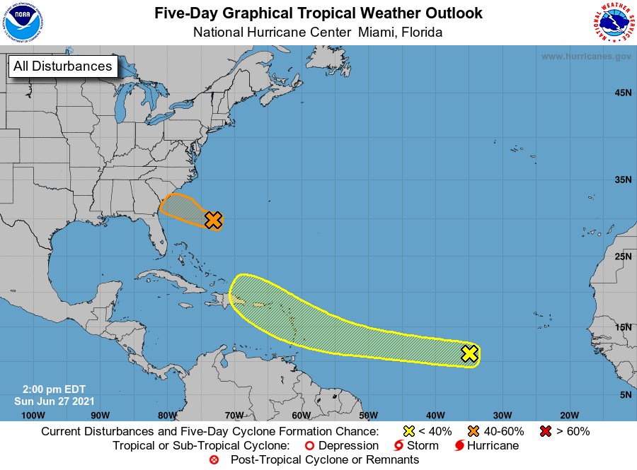
A Tropical Outlook issued by the National Hurricane Center shows two areas of concern being watched in the Atlantic, with the greatest chances of development occurring with the system near the U.S..  Image: NHC
A Tropical Outlook issued by the National Hurricane Center shows two areas of concern being watched in the Atlantic, with the greatest chances of development occurring with the system near the U.S..
Image: NHC

According to the NHC, satellite imagery and nearby buoy and ship observations indicate that a small low pressure system has formed about 500 miles east-southeast of the Georgia-South Carolina border. Surface pressures have begun to fall across the area, and showers and thunderstorms have recently become better organized. Some additional development of this system will be possible later today, and especially on Monday when the system will move across the warmer waters of the Gulf Stream, and a tropical depression could form before the system makes landfall along the southern U.S. coast. The low is expected to move westward today, and then west-northwestward at about 15 mph on Monday, reaching the coast of the southeastern United States by late Monday.

The National Hurricane Center still isn’t certain that a full tropical cyclone will form here over the next 36 hours, putting 50-50 odds of development on the system.

The NHC is also monitoring another disturbance over the central Atlantic. However, that is less likely than the system closest to the U.S. to develop into a tropical cyclone over the next 2-5 days.


Primary Sidebar

Sponsored Ad

Search

Latest News

  • Hurricane Center Says East Coast System Likely to Develop
  • National Hurricane Center Increases Odds of Cyclone Development Near Florida
  • Severe Weather Outbreak Likely in Mid Atlantic
  • July to Start with Severe Weather Event in New Jersey, Pennsylvania, Delaware, & Maryland
  • Tropical Storm Barry Forms; Additional Storm Possible Near Florida
  • Severe Weather Threat & Tornado Risk Returns to Northeast Today
  • Hurricane Center Monitoring Possible Gulf Disturbance
  • Bolide Explodes over Southeastern United States; Piece Crashes into Home
About | Careers | Contact | Contests
Terms | Privacy | Ad Choices
Weatherboy is a (R) Registered Trademark of isarithm LLC, All Rights Reserved.
All content herein is Copyright by Isarithm LLC 1997-2022